
Further explanation forthcoming, but at the GGW meet-up in Silver Spring tonight, a couple folks asked me about it, so here it is
What is on it?
-Potential extension of existing and under construction Metro Lines (including Silver), separated from each other to maximize capacity
-Two Metro Light Rail lines, the Purple Line (proposed) and the Black or "Columbia" Line (which hits Columbia Pike in MoCo, Columbia Heights, and Columbia Pike in VA)
-A vision for DC streetcars (red), Ride-On streetcars (light blue), streetcars for municipalities in Prince George's (various blues and purples), ART/DART (light green) and Fairfax Connector (white)
-Southern Maryland Area Rail Transport (SMART light rail, in yellow)
What's not on here yet:
-Corridor Cities Transitway
-MARC/VRE
-Baltimore Transit
-A "Pink Line" heavy rail inner loop
-A "Brown Line" crosstown light rail
I probably won't add these, it doesn't mean I don't think we should have them:
-Tram/Streetcar stations
-Intercity/HSR/MagLev
-Rapid/express bus (vision supplants most of this with rail anyway)
-Redevelopment and suburban ruralization that would ideally accompany this sort of plan
-Bicycle facilities (not my wheelhouse... yet)
-New/changed/removed freeways, parkways, and interchanges, as well as newly tolled roads
Here's a disclaimer: I am not under the delusion that this vision is feasible, politically expedient, affordable, cost effective, or in any other way possible. But I imagine it would be able to quickly and safely transport most of the area's growing population after gas prices breach the threshold of affordability.
Sorry I am currently incapable of putting together a beautiful graphic like many of my fellow transit nerds at BeyondDC, Track Twenty-Nine, or Greater Greater Washington, but hopefully the arrangement I have thrown together on GoogleMaps will give people an idea of what I'm going for here.
Showing posts with label Metro. Show all posts
Showing posts with label Metro. Show all posts
Wednesday, February 17, 2010

Saturday, November 21, 2009
Core Capacity & Freemark's Pink Line
The Transport Politic often showcases unique and clever transit solutions visualized by the site's author, Yonah Freemark. Recently he looked into the WMATA system and made an interesting proposal: a separated Blue Line, and running along it, another investment, a so-called Pink Line. Though Freemark's plan would add invaluable capacity and connectivity to our system, I believe a similar vision could be achieved without building another costly Potomac Crossing. That's not to say we shouldn't, but perhaps a closer term solution might look more like this:
View Pink Line in a larger map
The existing Potomac crossing where the Yellow Line connects Downtown and Pentagon City is underutilized and ought to have it's capacity increased before another crossing is built. This alternative combines the cross-Arlington connectivity that Freemark envisions without the circuitous route back through Rosslyn. This investment could be increased even more if the Green and Yellow Lines could be separated downtown, which might prove cheaper than the Blue Line separation. Another advantage would be that this line could just be an extension of the Silver Line, which would eliminate the need for a new line color.
New track miles are most valuable in the core. Unfortunately, they're also generally the most expensive new track miles. But the benefits to the entire region are huge across the entire system, making it a worthwhile investment. And it's about time we started considering "the rest of Arlington" more a part of the core.
View Pink Line in a larger map
The existing Potomac crossing where the Yellow Line connects Downtown and Pentagon City is underutilized and ought to have it's capacity increased before another crossing is built. This alternative combines the cross-Arlington connectivity that Freemark envisions without the circuitous route back through Rosslyn. This investment could be increased even more if the Green and Yellow Lines could be separated downtown, which might prove cheaper than the Blue Line separation. Another advantage would be that this line could just be an extension of the Silver Line, which would eliminate the need for a new line color.
New track miles are most valuable in the core. Unfortunately, they're also generally the most expensive new track miles. But the benefits to the entire region are huge across the entire system, making it a worthwhile investment. And it's about time we started considering "the rest of Arlington" more a part of the core.
Monday, October 19, 2009
Transit Capacity
Last month I criticized the plan to scale back Tysons Corner because of the need for increased freeway capacity. The more I think about it, the more merit I see in the notion that a revamped Tysons Corner will be desperately transit-starved. Freeways, however, are not the panacea. The plan to urbanize the region's most prominent edge city will bring thousands more jobs and residents to the area. Even if the area becomes more self contained, it will require much greater capacity for transportation in and out of the area's densest job center.
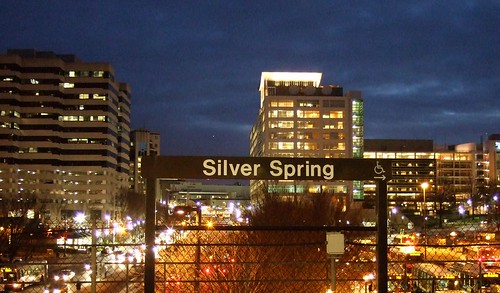 Downtown Silver Spring from the Metro station. Photo by mindgutter
Tysons will have 4 stations, but they will only be able to handle about 40% of the rides of stations at Silver Spring, Bethesda, Rosslyn, and King Street. Matt Johnson at Track Twenty-Nine created an excellent diagram showing how track sharing by Metro lines closer in to the city prevent the same capacities on the outer spokes of the system (except on the Red Line, which does not share tracks with any other line). Even with four stations, the capacity of the line does not stack up to urbanizations in Montgomery County, Arlington, and Alexandria. Can it support an even larger development with less system capacity? Can the already-clogged North Arlington Orange Line corridor support the additional riders with its finite capacity? Optimal success of the Tysons plan would require more Metro capacity such as a separated Blue Line on a new Potomac crossing.
I'm also lead to wonder if this has not contributed to the overall inferior urbanization in Prince George's County. No station in Prince George's has more than 60% capacity because the Green, Blue, and Orange lines all share track inside the District (though the northern section of the Green Line as the potential to do so if the Yellow Line ever runs all the way to Greenbelt regularly). Certainly the County's poor planning policies have contributed to the lack of urban development around virtually all 14 Metro stations, often egregiously, but perhaps lack of capacity has contributed as well.
The stretch of Metro in Prince George's County with the most service, the northern Green(/sometimes Yellow) Line has experienced the most development. Prince George's Plaza Station has probably seen the most. Though not exactly Downtown Silver Spring yet, University Town Center is probably the best example of urban development around a Metro station in Prince George's. Much has been planned for West Hyattsville, College Park, and Greenbelt, though little has come to fruition. New Carrollton, which will have added capacity once the Purple Line comes to town, also has grand plans for development. Stops on the Blue and lower Green Lines, however, are not experiencing as much planning buzz.
I have never heard of any study that implies the impact of station capacity versus development around stations, but it stands to reason that the more capacity, the more successful and robust development can be. The Orange Line corridor might be somewhat of an exception. West of Rosslyn, the Orange line can handle about 60% of the trips Silver Spring or Bethesda can handle. The strip is anchored, however, by Rosslyn, which has the same capacity as Silver Spring and Bethesda.
David Alpert suggested some innovative ways to create more system capacity by separating the Green and Yellow lines and rerouting some of the Silver Line trains. This would help Prince George's County, Tysons Corner, and other locations in Virginia and still be cheaper (in theory) than a separated Blue Line. If Silver Spring, Bethesda, and Rosslyn are models we seek to emulate, station capacity ought to be equivalent of those successful areas.
Downtown Silver Spring from the Metro station. Photo by mindgutterTysons will have 4 stations, but they will only be able to handle about 40% of the rides of stations at Silver Spring, Bethesda, Rosslyn, and King Street. Matt Johnson at Track Twenty-Nine created an excellent diagram showing how track sharing by Metro lines closer in to the city prevent the same capacities on the outer spokes of the system (except on the Red Line, which does not share tracks with any other line). Even with four stations, the capacity of the line does not stack up to urbanizations in Montgomery County, Arlington, and Alexandria. Can it support an even larger development with less system capacity? Can the already-clogged North Arlington Orange Line corridor support the additional riders with its finite capacity? Optimal success of the Tysons plan would require more Metro capacity such as a separated Blue Line on a new Potomac crossing.
I'm also lead to wonder if this has not contributed to the overall inferior urbanization in Prince George's County. No station in Prince George's has more than 60% capacity because the Green, Blue, and Orange lines all share track inside the District (though the northern section of the Green Line as the potential to do so if the Yellow Line ever runs all the way to Greenbelt regularly). Certainly the County's poor planning policies have contributed to the lack of urban development around virtually all 14 Metro stations, often egregiously, but perhaps lack of capacity has contributed as well.
The stretch of Metro in Prince George's County with the most service, the northern Green(/sometimes Yellow) Line has experienced the most development. Prince George's Plaza Station has probably seen the most. Though not exactly Downtown Silver Spring yet, University Town Center is probably the best example of urban development around a Metro station in Prince George's. Much has been planned for West Hyattsville, College Park, and Greenbelt, though little has come to fruition. New Carrollton, which will have added capacity once the Purple Line comes to town, also has grand plans for development. Stops on the Blue and lower Green Lines, however, are not experiencing as much planning buzz.
I have never heard of any study that implies the impact of station capacity versus development around stations, but it stands to reason that the more capacity, the more successful and robust development can be. The Orange Line corridor might be somewhat of an exception. West of Rosslyn, the Orange line can handle about 60% of the trips Silver Spring or Bethesda can handle. The strip is anchored, however, by Rosslyn, which has the same capacity as Silver Spring and Bethesda.
David Alpert suggested some innovative ways to create more system capacity by separating the Green and Yellow lines and rerouting some of the Silver Line trains. This would help Prince George's County, Tysons Corner, and other locations in Virginia and still be cheaper (in theory) than a separated Blue Line. If Silver Spring, Bethesda, and Rosslyn are models we seek to emulate, station capacity ought to be equivalent of those successful areas.
Thursday, June 25, 2009
Imagine A Seperate Green and Yellow Line
Naturally, there has been much written about the terrible Metro crash on the Red Line earlier this week. Had this been a nasty pile-up on the Beltway, we might have heard about it by by this point, we probably would have stopped talking about it by now, and it certainly never would have been international news. It is out of the ordinary, tragic, and was a failure of public infrastructure, unlike traffic accidents, which are usually the failures of individual drivers (we'll forgo the argument that fault may lie in road design). The fact that service disruptions continue on the Red Line is another reminder of this horrible accident. After all, these disruptions have a far greater impact on Metro than a bad traffic accident has on area highways.
If there is an accident on US-29 in Montgomery County, I can drive on Georgia or New Hampshire Avenues. But the stations that were shut down the past couple days isolated eastern Montgomery County from the rest of the Metro System. Originally, I tinkered with a map showing a separated Yellow Line for the sake of greater capacity and more geographic coverage for the Metro System. This week's accident has shown that adding redundancy to the system can be just as valuable as adding capacity.
Realizing the need for more redundancy on the system in the wake of this tragic crash is not an original idea. The Purple Line would obviously create alternate routes throughout the system. The Purple Line is both necessary and long overdue, however separating the Yellow and Green Lines would add capacity to existing track, much like separating the Blue and Orange Lines. In the case of the Yellow Line, it would allow for increased capacity on its Potomac River Bridge. If separated, the entire Green Line and the Yellow Line north of Pentagon would have the same capacity as the Red Line.
Here's what I would do with a separate Yellow Line:
View Separate Yellow Line in a larger map
This alignment is not 100% original either. Bringing Metro to North Capitol Street and Georgia Avenue is in no way a new idea. In these cases, however, people seem to want it for the geographic coverage, and not the additional capacity or system redundancy. Coverage is good, it brings transit to a new area. Capacity and redundancy, however, improve the entire system.
Perhaps I added a few too many stations, but they are just suggestions. While this would add service to the North Capitol Street and Georgia Avenue corridors, it would add redundancy to both the Green and Red Lines via Silver Spring, Georgia Av/Petworth, Union Station, and L'Enfant Plaza.
If this line existed already, the station closures on the Red Line might only have meant an additional transfer for Montgomery County commuters instead of the shuttle services to which Metro resorted after the crash.
If there is an accident on US-29 in Montgomery County, I can drive on Georgia or New Hampshire Avenues. But the stations that were shut down the past couple days isolated eastern Montgomery County from the rest of the Metro System. Originally, I tinkered with a map showing a separated Yellow Line for the sake of greater capacity and more geographic coverage for the Metro System. This week's accident has shown that adding redundancy to the system can be just as valuable as adding capacity.
Realizing the need for more redundancy on the system in the wake of this tragic crash is not an original idea. The Purple Line would obviously create alternate routes throughout the system. The Purple Line is both necessary and long overdue, however separating the Yellow and Green Lines would add capacity to existing track, much like separating the Blue and Orange Lines. In the case of the Yellow Line, it would allow for increased capacity on its Potomac River Bridge. If separated, the entire Green Line and the Yellow Line north of Pentagon would have the same capacity as the Red Line.
Here's what I would do with a separate Yellow Line:
View Separate Yellow Line in a larger map
This alignment is not 100% original either. Bringing Metro to North Capitol Street and Georgia Avenue is in no way a new idea. In these cases, however, people seem to want it for the geographic coverage, and not the additional capacity or system redundancy. Coverage is good, it brings transit to a new area. Capacity and redundancy, however, improve the entire system.
Perhaps I added a few too many stations, but they are just suggestions. While this would add service to the North Capitol Street and Georgia Avenue corridors, it would add redundancy to both the Green and Red Lines via Silver Spring, Georgia Av/Petworth, Union Station, and L'Enfant Plaza.
If this line existed already, the station closures on the Red Line might only have meant an additional transfer for Montgomery County commuters instead of the shuttle services to which Metro resorted after the crash.
Tuesday, April 7, 2009
Imagine Grosvenor
I have often heard the question as to why Montgomery County's western Red Line has not enjoyed the vibrant urbanism or Arlington's Orange Line. There are several reasons for this, of course. The Red Line's stations are much further apart and further from the downtown core. MD-355 does not have the supporting road network that Wilson Boulevard enjoys. MD-355 also has several obstacles to maintaining urban continuity, such as the Georgetown Preparatory School campus, The Naval Medical Center, Rock Creek Park, and the Beltway.
But the constant comparisons between the two areas have perhaps driven Montgomery County to try to live up to the Orange Line. The White Flint plan has been taking effect in recent months, complimenting the 2007 completion of Rockville Town Square. But these two developments are islandscompared to the continuous row of urbanism in Arlington. It will be difficult to fill in the gaps, as the Red Line's stations are further apart, but it can be done.
Which brings me to Grosvenor, at the southern end or Rockville Pike. It is an important station, as it is the western terminus for half of the Red Line's rush hour trains, and thus recieves more service than any station to the north. It serves Strathmore Hall, MoCo's prominent center for the performing arts. But don't expect to get dinner nearby the idyllic odieum, there is nowhere to eat in walking distance. In fact, apart from some town houses, some apartments that would make LeCorbusier hot and bothered, and a couple of huge private school campuses, there isn't much near Grosvenor station. There is, however, ample space.
The Georgetown Prep campus (one of the oldest in America) is a solid obstacle against integrating TOD around Grosvenor to the planned urban fabric of White Flint, but it could grow them much closer together, and make Grosvenor a bit more of a desination stop. Surface parking replaced with parking garages, a more continuous street grid, and a couple bistros near Strathmore Hall might make this possible. It could also make the Metro station more accessible to the nearby Garret Park community. As it stands, several nearby amenities in walking distance are inacessible to pedestrians because of the overt suburban design of the area. not the least of these amenities are the two high schools practically touching the station.
Here is what I imagine for a road network that would support this sort of development in Grosvenor:
View Larger Map
Unfortunately, I presume that the station's location at a major interstate junction (I-270 and I-495) would be expected to have enormous parking requirements. Given the affluence of the area, however, I wonder if this parking could be consolidated into garages so that a walkable development could emerge. I also fear that this would be nearly impossible to accomplish without the destruction of a lot of housing stock, primarily because of the wasteful land use of the existing developments, which are laid out with the towers-in-the-park mindset. Unfortunately, the "park" in towers in the park is usually automobile parking.
Grosvenor will probably never see anything quite this urban, but hopefully someone will invest in the ample dead space, taking advantage of the Metro station and performing arts center. Perhaps a high end restaurant could become the hot reservation on performance night. Until then, Grosvenor will just be a questionably placed station at the junction of Rockville Pike, the 270 Spur, and the Beltway, not a destination station.
But the constant comparisons between the two areas have perhaps driven Montgomery County to try to live up to the Orange Line. The White Flint plan has been taking effect in recent months, complimenting the 2007 completion of Rockville Town Square. But these two developments are islandscompared to the continuous row of urbanism in Arlington. It will be difficult to fill in the gaps, as the Red Line's stations are further apart, but it can be done.
Which brings me to Grosvenor, at the southern end or Rockville Pike. It is an important station, as it is the western terminus for half of the Red Line's rush hour trains, and thus recieves more service than any station to the north. It serves Strathmore Hall, MoCo's prominent center for the performing arts. But don't expect to get dinner nearby the idyllic odieum, there is nowhere to eat in walking distance. In fact, apart from some town houses, some apartments that would make LeCorbusier hot and bothered, and a couple of huge private school campuses, there isn't much near Grosvenor station. There is, however, ample space.
The Georgetown Prep campus (one of the oldest in America) is a solid obstacle against integrating TOD around Grosvenor to the planned urban fabric of White Flint, but it could grow them much closer together, and make Grosvenor a bit more of a desination stop. Surface parking replaced with parking garages, a more continuous street grid, and a couple bistros near Strathmore Hall might make this possible. It could also make the Metro station more accessible to the nearby Garret Park community. As it stands, several nearby amenities in walking distance are inacessible to pedestrians because of the overt suburban design of the area. not the least of these amenities are the two high schools practically touching the station.
Here is what I imagine for a road network that would support this sort of development in Grosvenor:
View Larger Map
Unfortunately, I presume that the station's location at a major interstate junction (I-270 and I-495) would be expected to have enormous parking requirements. Given the affluence of the area, however, I wonder if this parking could be consolidated into garages so that a walkable development could emerge. I also fear that this would be nearly impossible to accomplish without the destruction of a lot of housing stock, primarily because of the wasteful land use of the existing developments, which are laid out with the towers-in-the-park mindset. Unfortunately, the "park" in towers in the park is usually automobile parking.
Grosvenor will probably never see anything quite this urban, but hopefully someone will invest in the ample dead space, taking advantage of the Metro station and performing arts center. Perhaps a high end restaurant could become the hot reservation on performance night. Until then, Grosvenor will just be a questionably placed station at the junction of Rockville Pike, the 270 Spur, and the Beltway, not a destination station.
Thursday, March 12, 2009
Light Posting Lately; The Metro Vision Update

Apologies for the light posting lately. I have been working a recession-induced second job, and much of my transit-nerd time has been devoted to poking around in Google Earth tweaking my Mass Transit Vision. I don't have much graphic design experience (read: I have none) and I'm slowly and painfully trying to learn how to use Inkscape, so it will be a while before I can post. it.
Shown right: a very early concept sketch.
Since I have gotten quite a few inquiries on this project, I thought I'd share some information. First of all, it won't be something we're likely to see in my grand-children's lifetime. It would probably cost a trillion or more to construct, and it would have far more capacity than this area could support with its current infrastructure and population. I haven't measured its current length, but I know it would be over 500 miles of track. I'll even go so far as to say it would be irresponsible to even study may of the proposed changes.
The concept I'm working has a core system with thirteen (!) lines, none of which share any track (i.e., separated the Green, Yellow, Blue, Orange and Silver lines from each other) so as to maximize capacity. There are six heavy rail and seven light rail/street car lines, a couple of the latter are spurred at the ends. I extended every single end of every existing and planned heavy rail line, though mostly only a station or two here and there. There are also several infill stations, particularly on the new separated routes. The light rails incorporate plans like the Anacostia Light Rail, the Columbia Pike transitways (both in VA and in MD), The Purple Line, and other DC streetcar proposals. There are two Purple Lines, in fact, both of which loop around the city (the Silver Spring-New Carrolton is the outer line). Much of it is completely unfeasible because it would require a fantastic amount of expensive tunnelling, right-of-way acquisition, engineering, and construction.
I expanded on MARC and VRE (but removed the Camden Line) and removed some of the smaller stations, treating them more like an integrated express service. Most of the smaller stops (like Riverdale and Clifton) were replaces with light rail stops. I put four Metro Lines at Union Station and likewise concentrated rail traffic to other MARC/VRE nodes like Silver Spring, L'Enfant Plaza, Rockville, New Carrollton, and King Street to emphasize their role as express lines.

Shown right: a later concept.
Also included in this plan are five supplemental services. In Maryland, the Corridor Cities Transitway, a series of light rail or BRT lines through Montgomery County (which I called Ride-On) and a light rail loop through Southern Maryland. In Virginia, I threw in a series of light rail/BRT lines for Fairfax and Prince William Counties, as well as an Aerotram along the "Techway" corridor from Shady Grove in Rockville to Dulles International Airport.
I have always felt like others' transit visions lack service in Prince Georges County and River East, so there is a concentration in those areas. I placed transit stops in close-in traditionally planned communities like Hyattsville's Arts District, Takoma Park, Old Town, and other places.
Denser areas that are poorly planned (Seven Corners, Tysons, Eastern MoCo, etc.) received lots of transit assuming they would be redeveloped into more transit oriented areas. Parts of the system are very far flung (Columbia, Fort Washington, South Riding, Woodbridge, Gaithersburg, Odenton, etc.)
I don't know if I'll include them initially, but I also have an integrated plan for Frederick, Annapolis, Baltimore, and the Atlantic Beaches.

Shown right: the current iteration of the project.
Basically, my goal was to visualize a Washington Metropolitan area that could support a population at least twice its current size, while allowing most of the city and closer-in region to comfortably live without a car. Hence its infeasibility. It has been a fun and interesting project so far, even if it has been overkill.
If anyone has the free time to teach me Inkscape, I would be much obliged, and would gladly provide a meal in exchange. Sadly I lack the graphic skills of the many other transit visions that have inspired me to embark on this project.
So please bear with me as I work my two jobs and attempt to get this into a nice readable map for everyone.
Thursday, February 26, 2009
Imagine Prince George's Plaza
Though nowhere near up to par with Arlington's Rosslyn-Ballston Corridor, Old Town Alexandria, or the central business districts of Bethesda and Silver Spring, Prince George's Plaza might be the best example of transit-oriented development in Prince George's County. It combines a Metro station with heavy retail, medium density housing, and a walkable street grid. Unfortunately, those things are not integrated with each other.
I love the City of Hyattsville. As soon as I can afford to do so, I plan on moving there. It has a ton of potential. Potential, however, means room for improvement.
Anecdotally, I was told by a Hyattsville Police officer that the city plans to annex and redevelop the suburban style medium-density apartment complexes north and west of the mall. In this same conversation, the officer, who was advising me on where the city experienced most crime, cited garden style apartment complexes like these (like Kirkwood near West Hyattsville station or the apartments on the southwest corner of University and Adelphi) as the worst offenders. I can only assume the isolation of the buildings behind PG Plaza makes them ideal places to engage in criminal activity.
Generally, I don't like the idea of putting heavy transit near a mall. Malls are inherently car-oriented, and over the past decade they have experienced severe decline in image and practicality. The Mall at Prince George's (which I will forever call PG Plaza despite its new name and this newfangled civic movement against saying "PG" in favor of "Prince George's") might be able to take advantage of the Metro station across the street.
Many of the larger development projects in Prince George's County have been greenfield developments outside the Beltway and far from transit taking on a semi-new urbanist format, but are far from transit and isolated from the better urban design closer in. Bowie Town Center and National Harbor are good yardsticks for what we can expect out of planned developments at Brandywine, Westphalia(pdf), Konterra, and Woodmore Town Center (pdf): far from existing transit, isolated pockets of walkable mixed use surrounded by parking. PG Plaza, if redeveloped, can present a retail design similar to that of Bowie Town Center with the added advantage of being across the street from a Metro station in an area that can easily be reticulated into the surrounding street grid.
Remove the roof, which PG Plaza didn't always have anyway, and lay down the grid. I give you new Hyattsville:
View Larger Map
With this, perhaps more pedestrian friendly changes will occur as well. East-West Highway has three shockingly bad design flaws on that stretch. First, the median fences. Anytime a street has a fenced median to discourage jaywalking, it's a sure sign of poor design. Pedestrian traffic is like water flow. It will find the path of least resistance from origin to destination, and will creatively by-pass obstacles. Instead of trying to force pedestrians to go out of their way to cross East-West, embrace the foot traffic with more crossings, traffic signals, and a parallel street to spread out the traffic.
Next, the pedestrian bridge from the Metro station to the mall parking lot has to go. Parking ought to be consolidated into a garage, and the street frontage should be developed. pedestrian bridges over suburban arteries like this are not functional, they encourage speeding on the road, they kills street life, and they are unbearably tacky. Perhaps if the street frontage has an arcade with an upper level of shops and whatnot, it could stay, but generally it looks horrible and it proves to be cumbersome for access to the Metro station.
Third, rename the damn road. East-West Highway (MD route 410) is a title unbecoming for a road passing through the CBD's of Bethesda, Silver Spring, Takoma Park, and Hyattsville. In Takoma Park, 410 is actually called Ethan Allen Avenue. Perhaps Hyattsville could follow suit and rename it something like "John Clark Hyatt Avenue" after the town's founder. Apt, historical, and far less generic.
Hyattsville is evolving as a city. It has come a very, very long way in the last decade, and it continues to grow and improve. PG Plaza will undoubtedly emerge as a hot spot for good urbanism. Eyesores like the pedestrian bridge will be replaced by more of what we're seeing in the nearby Hyattsville Arts District, and instead of an island of good urbanism, it will grow into the fabric of the surrounding areas.
I love the City of Hyattsville. As soon as I can afford to do so, I plan on moving there. It has a ton of potential. Potential, however, means room for improvement.
Anecdotally, I was told by a Hyattsville Police officer that the city plans to annex and redevelop the suburban style medium-density apartment complexes north and west of the mall. In this same conversation, the officer, who was advising me on where the city experienced most crime, cited garden style apartment complexes like these (like Kirkwood near West Hyattsville station or the apartments on the southwest corner of University and Adelphi) as the worst offenders. I can only assume the isolation of the buildings behind PG Plaza makes them ideal places to engage in criminal activity.
Generally, I don't like the idea of putting heavy transit near a mall. Malls are inherently car-oriented, and over the past decade they have experienced severe decline in image and practicality. The Mall at Prince George's (which I will forever call PG Plaza despite its new name and this newfangled civic movement against saying "PG" in favor of "Prince George's") might be able to take advantage of the Metro station across the street.
Many of the larger development projects in Prince George's County have been greenfield developments outside the Beltway and far from transit taking on a semi-new urbanist format, but are far from transit and isolated from the better urban design closer in. Bowie Town Center and National Harbor are good yardsticks for what we can expect out of planned developments at Brandywine, Westphalia(pdf), Konterra, and Woodmore Town Center (pdf): far from existing transit, isolated pockets of walkable mixed use surrounded by parking. PG Plaza, if redeveloped, can present a retail design similar to that of Bowie Town Center with the added advantage of being across the street from a Metro station in an area that can easily be reticulated into the surrounding street grid.
Remove the roof, which PG Plaza didn't always have anyway, and lay down the grid. I give you new Hyattsville:
View Larger Map
With this, perhaps more pedestrian friendly changes will occur as well. East-West Highway has three shockingly bad design flaws on that stretch. First, the median fences. Anytime a street has a fenced median to discourage jaywalking, it's a sure sign of poor design. Pedestrian traffic is like water flow. It will find the path of least resistance from origin to destination, and will creatively by-pass obstacles. Instead of trying to force pedestrians to go out of their way to cross East-West, embrace the foot traffic with more crossings, traffic signals, and a parallel street to spread out the traffic.
Next, the pedestrian bridge from the Metro station to the mall parking lot has to go. Parking ought to be consolidated into a garage, and the street frontage should be developed. pedestrian bridges over suburban arteries like this are not functional, they encourage speeding on the road, they kills street life, and they are unbearably tacky. Perhaps if the street frontage has an arcade with an upper level of shops and whatnot, it could stay, but generally it looks horrible and it proves to be cumbersome for access to the Metro station.
Third, rename the damn road. East-West Highway (MD route 410) is a title unbecoming for a road passing through the CBD's of Bethesda, Silver Spring, Takoma Park, and Hyattsville. In Takoma Park, 410 is actually called Ethan Allen Avenue. Perhaps Hyattsville could follow suit and rename it something like "John Clark Hyatt Avenue" after the town's founder. Apt, historical, and far less generic.
Hyattsville is evolving as a city. It has come a very, very long way in the last decade, and it continues to grow and improve. PG Plaza will undoubtedly emerge as a hot spot for good urbanism. Eyesores like the pedestrian bridge will be replaced by more of what we're seeing in the nearby Hyattsville Arts District, and instead of an island of good urbanism, it will grow into the fabric of the surrounding areas.
Saturday, February 21, 2009
Lady Bird Johnson Park
I have always thought Lady Bird Johnson Park was a little strange. Though closer to the Virginia shore, this island lies completely within the District, much like Roosevelt Island to the northwest. Although, unlike Roosevelt, this island is overrun with freeway spaghetti, most of it serving the Commonwealth and not the District. Also, this area is served by a Metro station, Arlington Cemetery. There is no residential, commercial, office, or industrial construction on the island, save a small marina on the south end. There are no park facilities. The entire area just seems like a serene setting to plop down a bunch of (confusing) highways.
Considering Lady Bird Johnson's efforts to beautify our nation's freeways, I suppose this is somewhat fitting (and probably intentional). though her Highway Beautification Act pertained mostly to interstates and ironically none of the highways on her island are interstates. Still, it seems like such a waste of a land. Why call it a "park" if there are no park facilities? It's not exactly the kind of place one can picnic or hike.
I would like to see the highway lanes consolidated, perhaps with some modest low rise apartments on the north side of the island oriented to the Metro station. And open the island up with some trails and waterside park facilities. Right now, the District seems to be allowing this land to be utilized only by the commuters in Arlington County.
Considering Lady Bird Johnson's efforts to beautify our nation's freeways, I suppose this is somewhat fitting (and probably intentional). though her Highway Beautification Act pertained mostly to interstates and ironically none of the highways on her island are interstates. Still, it seems like such a waste of a land. Why call it a "park" if there are no park facilities? It's not exactly the kind of place one can picnic or hike.
I would like to see the highway lanes consolidated, perhaps with some modest low rise apartments on the north side of the island oriented to the Metro station. And open the island up with some trails and waterside park facilities. Right now, the District seems to be allowing this land to be utilized only by the commuters in Arlington County.
Thursday, February 12, 2009
Imagine West Hyattsville
West Hyattsville Metro Station is one of the most underutilized stations on the Metro system, standing out even in TOD-beleaguered Prince George's County. It stands seemingly in a large field, discouraging the station's use as anything but a commuter stop. The County has plans (pdf) for vitalizing the area around the station, but I thought I might take a crack at it myself with some street connectivity.
View Larger Map
Queens Chapel Town Center has a great deal of potential to anchor a strong retail district. The area, at the intersection of Chillum, Mount Rainier, and Hyattsville, has the population to support retail progress. The success of the nearby Hyattsville Arts District has changed the image of the area. West Hyattsville, connected to the Arts District by a traditional suburban street grid, is poised to parlay the success of one of Prince George's County's most popular real estate ventures into success of its own. Only the presence of a Metro station,
The Northwest Branch runs just to the south of the station, but instead of serving as a barrier, I believe this watercourse can be embraced by development with small waterside paths. I included several new bridges over it, connecting potential new developments to the Metro station. The key element, in this case, is adding parallel roads. As I have stated time and time again (as with many before me), a street grid reduces traffic, lessens vehicle miles traffic, and eliminates car trips as the area becomes more walkable. Hopefully a developer with the vision will take advantage of the opportunity, and hopefully the County won't block any progressive efforts. Hyattsville could become the new Bethesda, it just takes some progressive leadership to make it happen.
View Larger Map
Queens Chapel Town Center has a great deal of potential to anchor a strong retail district. The area, at the intersection of Chillum, Mount Rainier, and Hyattsville, has the population to support retail progress. The success of the nearby Hyattsville Arts District has changed the image of the area. West Hyattsville, connected to the Arts District by a traditional suburban street grid, is poised to parlay the success of one of Prince George's County's most popular real estate ventures into success of its own. Only the presence of a Metro station,
The Northwest Branch runs just to the south of the station, but instead of serving as a barrier, I believe this watercourse can be embraced by development with small waterside paths. I included several new bridges over it, connecting potential new developments to the Metro station. The key element, in this case, is adding parallel roads. As I have stated time and time again (as with many before me), a street grid reduces traffic, lessens vehicle miles traffic, and eliminates car trips as the area becomes more walkable. Hopefully a developer with the vision will take advantage of the opportunity, and hopefully the County won't block any progressive efforts. Hyattsville could become the new Bethesda, it just takes some progressive leadership to make it happen.
Tuesday, January 13, 2009
How I'm Getting to the Inauguration
Hopefully I'll be over my cold by then, but I do plan on attending the Inauguration, which is now only a week away. But with massive transportation issues that day and estimates as high as 5 million people coming to town, getting there seems to be a scary proposition.
I'll have two out of town visitors that I'm putting up at my home in Laurel. My usual stations of choice are Greenbelt, College Park, Cheverly, and New Carrollton. But considering that the Green and Orange Lines are located on the Beltway, I think I'm going to try a different approach.
I'll be heading to Silver Spring Metro station. Here's why: first of all, the other stations on that end of the Red Line (Forest Glen, Wheaton, and Glenmont) will certainly see a great deal of volume, but I do not believe that the gobs of out-of-towners will be flooding them the way they will at Shady Grove, New Carrollton, and Greenbelt, considering the much more "ideal" locations of those stations being at major highway junctions. Forest Glen is right off the Beltway, but it is a tiny station, and it is not marked on the Beltway the way other stations are.
Second, Silver Spring has plenty of stuff to do. If for some reason I make it down there and there is good reason not to go into the city, there are dozens of places to go and watch history unfold on TV. I plan on catching dinner there after the festivities, and showing the area off to my cousin and his friend.
Third, ample parking. As a car-oriented person, I have to take this into account. Hopefully you won't have to do so. Silver Spring has ample garages, and there ought to be enough folks getting off work to make parking there a viable option. Also, I don't believe that tour buses will be flooding this station in the same manner that they will be flooding other outer stations.
My the first reason is my primary reason. I figure people coming from points south will flood the VA stations. From the northeast, they'll all head towards Greenbelt. From the northwest, Shady Grove, and from the east, New Carrollton. Perhaps Huntington and Branch Avenue might be decent options by that logic. Does anyone else have any good plan for getting down there? Are there major flaws in my logic? How are you getting down there?
I'll have two out of town visitors that I'm putting up at my home in Laurel. My usual stations of choice are Greenbelt, College Park, Cheverly, and New Carrollton. But considering that the Green and Orange Lines are located on the Beltway, I think I'm going to try a different approach.
I'll be heading to Silver Spring Metro station. Here's why: first of all, the other stations on that end of the Red Line (Forest Glen, Wheaton, and Glenmont) will certainly see a great deal of volume, but I do not believe that the gobs of out-of-towners will be flooding them the way they will at Shady Grove, New Carrollton, and Greenbelt, considering the much more "ideal" locations of those stations being at major highway junctions. Forest Glen is right off the Beltway, but it is a tiny station, and it is not marked on the Beltway the way other stations are.
Second, Silver Spring has plenty of stuff to do. If for some reason I make it down there and there is good reason not to go into the city, there are dozens of places to go and watch history unfold on TV. I plan on catching dinner there after the festivities, and showing the area off to my cousin and his friend.
Third, ample parking. As a car-oriented person, I have to take this into account. Hopefully you won't have to do so. Silver Spring has ample garages, and there ought to be enough folks getting off work to make parking there a viable option. Also, I don't believe that tour buses will be flooding this station in the same manner that they will be flooding other outer stations.
My the first reason is my primary reason. I figure people coming from points south will flood the VA stations. From the northeast, they'll all head towards Greenbelt. From the northwest, Shady Grove, and from the east, New Carrollton. Perhaps Huntington and Branch Avenue might be decent options by that logic. Does anyone else have any good plan for getting down there? Are there major flaws in my logic? How are you getting down there?
Friday, January 9, 2009
Metro Question
Can Metro run 24-7 if it is single tracked during the hours which it is otherwise closed? I'm sure many people would love 24/7 Metro, but I have been told the primary reason we cannot do this is because Metro lacks the ancillary tracks of the New York City System. Track maintenance would be impossible if the lines never closed... but if they single tracked during the overnight alternating tracks each night, would it still be possible to maintain the tracks while running trains, say every hour or so?
Wednesday, January 7, 2009
Another Great Metro Vision
Beyond DC, GGW, and Track Twenty Nine have all done incredible visions of what Metro could look like in the future. Now Цаrьchitect has envisioned something entirely different for the Blue Line.
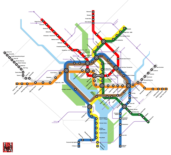
I highly recommend checking Цаrьchitect's map and his description of the proposal. One of these days, I promise I'll get my own out onto the internet.
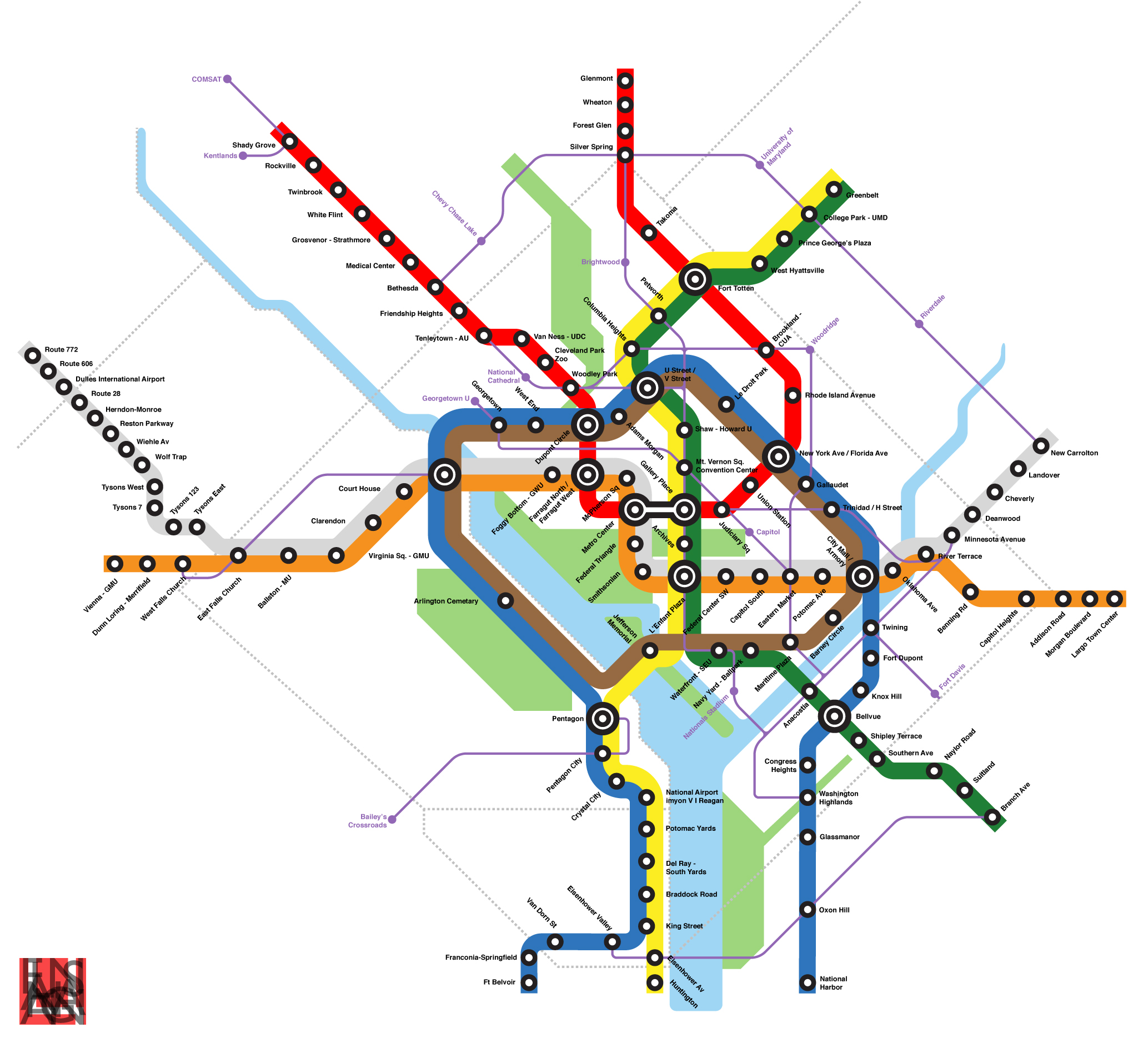
I highly recommend checking Цаrьchitect's map and his description of the proposal. One of these days, I promise I'll get my own out onto the internet.
Tuesday, January 6, 2009
Stupid Growth: Landover Metro
It's no secret that PG County is lousy at developing around its Metro stations. But check this madness out by Landover Metro station on the Orange Line:
View Larger Map
In the bottom right (southeast) is what at first glance looks like a bunch of huge single family homes. on second glance, I'm pretty sure they are apartments. But even if they are, they are incredibly suburban considering their proximity to Landover station. And proximity is something that station has in short supply.
To the north and west, the station is bulwarked by US-50. No pedestrian facilities to serve the neighborhood a stone's throw away on Parkwood Street. Instead, you have to drive almost a mile via Landover Road and Pennsy Drive to get to the station. At that point, most people may as well drive to Stadium-Armory or Eastern Market. Even low density neighborhoods should have access to their nearby stations.
But back to that residential development on 75th Avenue... granted, I've only been to Landover station once or twice, and I've never seen this development in person. But it doesn't appear to have any safe and direct access to the Metro station a couple blocks away. The only close thing to Landover station is ample parking. And there are few places where Landover station is more convenient than New Carrollton or Cheverly, or even driving. This is not how development around stations ought to look. This is why Landover and Cheverly are among the least used stations on the Orange Line
Industrial super-blocks around Metro stations definitely need to be broken up and repurposed for mixed use. Otherwise, the incentive to use trains is diminished, which increases traffic and devalues the investment in Metro. This is an unfortunate patter on the eastern end of the Orange line. More practical development practices must be embraced at these stations, otherwise they could become a financial strain on the rest of the system, obsolete stops slowing the trip from New Carrollton to Downtown.
View Larger Map
In the bottom right (southeast) is what at first glance looks like a bunch of huge single family homes. on second glance, I'm pretty sure they are apartments. But even if they are, they are incredibly suburban considering their proximity to Landover station. And proximity is something that station has in short supply.
To the north and west, the station is bulwarked by US-50. No pedestrian facilities to serve the neighborhood a stone's throw away on Parkwood Street. Instead, you have to drive almost a mile via Landover Road and Pennsy Drive to get to the station. At that point, most people may as well drive to Stadium-Armory or Eastern Market. Even low density neighborhoods should have access to their nearby stations.
But back to that residential development on 75th Avenue... granted, I've only been to Landover station once or twice, and I've never seen this development in person. But it doesn't appear to have any safe and direct access to the Metro station a couple blocks away. The only close thing to Landover station is ample parking. And there are few places where Landover station is more convenient than New Carrollton or Cheverly, or even driving. This is not how development around stations ought to look. This is why Landover and Cheverly are among the least used stations on the Orange Line
Industrial super-blocks around Metro stations definitely need to be broken up and repurposed for mixed use. Otherwise, the incentive to use trains is diminished, which increases traffic and devalues the investment in Metro. This is an unfortunate patter on the eastern end of the Orange line. More practical development practices must be embraced at these stations, otherwise they could become a financial strain on the rest of the system, obsolete stops slowing the trip from New Carrollton to Downtown.
Tuesday, December 30, 2008
Car Oriented
I chose to live close to my work at Fort Meade thinking I would drive less. I live close to the base on which I work, and since there's bubkes for transit options to the base, I figure it is best to shorten my commute. It will save money. I'll drive less.
But instead I drive more, since I can't go anywhere from my Laurel neighborhood without driving... not even the grocery store two blocks away, as no sane person would attempt to cross Route 1 while carrying something. And considering that I'm a single 29 year old with an active social life, I like to venture out of Laurel as often as possible. I have a part-time night job in Bethesda, volunteer with a youth program in Silver Spring, I have a ton of friends that live in places like Capitol Hill, Rosslyn, and Dupont, my familiy lives mostly in Silver Spring, and I like to attend sporting events in DC and Landover. All of those locations have one distinct advantage over Laurel: Metro stations.
The buses on Route 1 is painfully slow even during off-peak hours. It doesn't run past 8pm, which is generally when I get off work, and is less reliable on the weekends. Greenbelt and Cheverly Metro stations are where I usually hop on the Metro if I'm going into DC or Virginia, but even those are 15 minute drives in light traffic.
I won't shy away from the fact that I enjoy a good glass of scotch or two from time to time, but I have to plan carefully if I want to go meet friends in Bethesda, Old Town, or H Street for a couple of drinks. Fact is, 100% of drunk drivers are driving at the time. I wonder how many DUI's Metro has prevented over the years.
I try to combine trips as often as possible, but walking anywhere from my house is laborious. There are no sidewalks in my neighborhood. Route 1, where every road in my neighborhood empties, has few sidewalks on my stretch and even fewer crosswalks. Most retail near me is hidden behind a sea of paking lots, including the moribund Laurel Mall, where I only shop when I am absolutely desperate (although here's a great secret: the Macy's there is always fully stocked because no one shops there).
For someone who hates paperwork as much as I do, driving is a nightmare. There is insurance, an expensive necessary evil to legally drive in most of the US. If you live anywhere near a city, the price goes up significantly. MVA (which is Marylandese for DMV) registration, tags, and drivers license are relatively cheap, but minor oversights are costly. Should insurance, tags, license, or registration lapse, there are heavy penalties. Then there is the occaisional parking ticket (I have had plenty at work when parking was particularly bad and I chanced it in a reserve space) and if you're really not paying attention, speed camera ($50 for 36 mph on Minnesota Avenue at 3 a.m. last month... I'm not complaining about speed cameras, but ouch).
The real cost of my car oriented lifestyle is huge. I make a decent living on a federal salary. I'm certainly not loaded, but I make a decent wage by most standards. My car is a modest American sedan that gets 30 mpg that I purchased used on a 5 year loan. My car payment, insurance, scheduled maintenance, and gas (to and from work ONLY, assuming $2/gal) eats up over 20% of my take home salary, which includes my federal salary, my VA disability, and my night job. I don't care how much anyone makes. 20% of any living wage is ludicrous. And that 20% doesn't include emergency repairs (like a new set of tires that wasn't covered by my insurance, $600), tickets, MVA fees, or gas to get anywhere besides work. And to add insult to injury, my tax dollars are now going to bail out the automakers. I already gave them my money when I purchased my car. Rest assured that when I purchase another one, it will not be a GM, Ford, or Chrysler.
That's 20% I can't spend on improving my house. If it comes down to it, an emergency repair on my car takes precedence over one for my house, because I can't get to work without my car. The irrational prioritization I am forced to uphold for my automobile is absurd, but it is a simple fact that most Americans take in stride. Supposedly offering the freedom of mobility, many Americans are in my position, and I consider myself a slave to my car.
Why did I take this in stride most of my life? I was raised in a car-oriented suburb in Silver Spring, a quarter mile from a Beltway exit. The only thing I could walk to from my house without a very long trek involving significant distance along a six lane highway was the community swimming pool, which of course was only open three months a year. I attended high school four miles from my house at a private school with no bus service. I would take Metrobus home from school often, however the school has since relocated far away from the a Metro station and I would not have that option today.
Furthermore, as Rob at Extraordinary Observations points out, previous generations (i.e., the parents who raised us) venerate automobiles. Cars were status symbols and not necessary evils. Where our parents dreamt of moving out to the suburbs, today's young adults are flocking back to the cities. To the Cold War generation, riding transit could be compared to people today who use Walkmans instead of iPods... it spurned progress while at the same time it was a sign of weakness. He also points out that young adults enter the work force from college with enormous debt, which most of our parents did not face. Six figure debt at age 23 is not uncommon in our society, as medical costs and especially college tuition increase have greatly outpaced income increases.
After high school I attended Montgomery College in Rockville, to which I drove, and worked at a store in Cleveland Park, to which I took Metro when feasible. After college, I joined the Army. I have repeatedly stated that it is nearly impossible to get by in the US Army without an automobile, an overpowering irony for the service that prides itself on "beating feet". So when I purchased my house five years ago, I thought I was doing the responsible thing living close to work. And perhaps, to a degree, I was. But living far from transit has cost me a great deal, even if I can't take transit to work.
Don't get me wrong, I love driving. I find it cathartic to be on an open road. For liesure, I used to drive out to northwestern Montgomery County and take in the sights. I always offer to drive on road trips. I love that I can hop in the car on a whim and go just about anywhere in America I choose. But there is a distinct difference between chosing to drive and being wholly dependent on an automobile. There is a difference between driving for leisure and driving because you are forced to drive.
Currently, the extra money that goes into driving is ironically prohibiting me from improving my location by moving somewhere more transit accessible. I probably will never give up driving, but I am committed to driving less. More importantly, I will continue to remind myself and those around me how expensive it can be when you lead a car-oriented lifestyle.
But instead I drive more, since I can't go anywhere from my Laurel neighborhood without driving... not even the grocery store two blocks away, as no sane person would attempt to cross Route 1 while carrying something. And considering that I'm a single 29 year old with an active social life, I like to venture out of Laurel as often as possible. I have a part-time night job in Bethesda, volunteer with a youth program in Silver Spring, I have a ton of friends that live in places like Capitol Hill, Rosslyn, and Dupont, my familiy lives mostly in Silver Spring, and I like to attend sporting events in DC and Landover. All of those locations have one distinct advantage over Laurel: Metro stations.
The buses on Route 1 is painfully slow even during off-peak hours. It doesn't run past 8pm, which is generally when I get off work, and is less reliable on the weekends. Greenbelt and Cheverly Metro stations are where I usually hop on the Metro if I'm going into DC or Virginia, but even those are 15 minute drives in light traffic.
I won't shy away from the fact that I enjoy a good glass of scotch or two from time to time, but I have to plan carefully if I want to go meet friends in Bethesda, Old Town, or H Street for a couple of drinks. Fact is, 100% of drunk drivers are driving at the time. I wonder how many DUI's Metro has prevented over the years.
I try to combine trips as often as possible, but walking anywhere from my house is laborious. There are no sidewalks in my neighborhood. Route 1, where every road in my neighborhood empties, has few sidewalks on my stretch and even fewer crosswalks. Most retail near me is hidden behind a sea of paking lots, including the moribund Laurel Mall, where I only shop when I am absolutely desperate (although here's a great secret: the Macy's there is always fully stocked because no one shops there).
For someone who hates paperwork as much as I do, driving is a nightmare. There is insurance, an expensive necessary evil to legally drive in most of the US. If you live anywhere near a city, the price goes up significantly. MVA (which is Marylandese for DMV) registration, tags, and drivers license are relatively cheap, but minor oversights are costly. Should insurance, tags, license, or registration lapse, there are heavy penalties. Then there is the occaisional parking ticket (I have had plenty at work when parking was particularly bad and I chanced it in a reserve space) and if you're really not paying attention, speed camera ($50 for 36 mph on Minnesota Avenue at 3 a.m. last month... I'm not complaining about speed cameras, but ouch).
The real cost of my car oriented lifestyle is huge. I make a decent living on a federal salary. I'm certainly not loaded, but I make a decent wage by most standards. My car is a modest American sedan that gets 30 mpg that I purchased used on a 5 year loan. My car payment, insurance, scheduled maintenance, and gas (to and from work ONLY, assuming $2/gal) eats up over 20% of my take home salary, which includes my federal salary, my VA disability, and my night job. I don't care how much anyone makes. 20% of any living wage is ludicrous. And that 20% doesn't include emergency repairs (like a new set of tires that wasn't covered by my insurance, $600), tickets, MVA fees, or gas to get anywhere besides work. And to add insult to injury, my tax dollars are now going to bail out the automakers. I already gave them my money when I purchased my car. Rest assured that when I purchase another one, it will not be a GM, Ford, or Chrysler.
That's 20% I can't spend on improving my house. If it comes down to it, an emergency repair on my car takes precedence over one for my house, because I can't get to work without my car. The irrational prioritization I am forced to uphold for my automobile is absurd, but it is a simple fact that most Americans take in stride. Supposedly offering the freedom of mobility, many Americans are in my position, and I consider myself a slave to my car.
Why did I take this in stride most of my life? I was raised in a car-oriented suburb in Silver Spring, a quarter mile from a Beltway exit. The only thing I could walk to from my house without a very long trek involving significant distance along a six lane highway was the community swimming pool, which of course was only open three months a year. I attended high school four miles from my house at a private school with no bus service. I would take Metrobus home from school often, however the school has since relocated far away from the a Metro station and I would not have that option today.
Furthermore, as Rob at Extraordinary Observations points out, previous generations (i.e., the parents who raised us) venerate automobiles. Cars were status symbols and not necessary evils. Where our parents dreamt of moving out to the suburbs, today's young adults are flocking back to the cities. To the Cold War generation, riding transit could be compared to people today who use Walkmans instead of iPods... it spurned progress while at the same time it was a sign of weakness. He also points out that young adults enter the work force from college with enormous debt, which most of our parents did not face. Six figure debt at age 23 is not uncommon in our society, as medical costs and especially college tuition increase have greatly outpaced income increases.
After high school I attended Montgomery College in Rockville, to which I drove, and worked at a store in Cleveland Park, to which I took Metro when feasible. After college, I joined the Army. I have repeatedly stated that it is nearly impossible to get by in the US Army without an automobile, an overpowering irony for the service that prides itself on "beating feet". So when I purchased my house five years ago, I thought I was doing the responsible thing living close to work. And perhaps, to a degree, I was. But living far from transit has cost me a great deal, even if I can't take transit to work.
Don't get me wrong, I love driving. I find it cathartic to be on an open road. For liesure, I used to drive out to northwestern Montgomery County and take in the sights. I always offer to drive on road trips. I love that I can hop in the car on a whim and go just about anywhere in America I choose. But there is a distinct difference between chosing to drive and being wholly dependent on an automobile. There is a difference between driving for leisure and driving because you are forced to drive.
Currently, the extra money that goes into driving is ironically prohibiting me from improving my location by moving somewhere more transit accessible. I probably will never give up driving, but I am committed to driving less. More importantly, I will continue to remind myself and those around me how expensive it can be when you lead a car-oriented lifestyle.
Monday, November 3, 2008
Are You Ready For Some Metro
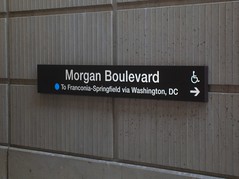 Monday Night Football, the NFL's major prime time network(-cum-basic-cable) broadcast has come to FedEx Field once again. Even more exciting than the normal hyperbole of MNF game is the fact that the 6-2 Redskins are playing the 5-2 Pittsburgh Steelers, a game that lots of people are actually going to care about for a change. Redskins Nation is buzzing.
If you commute on the eastern half of the Beltway, however, your afternoon drive will probably be much slower, as FedEx Field opens the lots four hours before the 9 pm kickoff and tailgaters will likely be jamming exits 15, 16, and 17 during the evening rush, as happens for every weeknight home game at FedEx Field. But Metro is pulling their weight, just like they did for the last Monday Night game at FedEx, the 2006 season opener. The system will be staying open until 1 a.m., with additional personnel at Morgan Boulevard and Largo stations.
Considering that FedEx Field opened in 1997 but Morgan Boulevard and Largo stations did not open until 2004, Metro use during mega-events at the stadium does not make headlines like Nationals Park did when it opened atop a Green Line station this spring. People took notice that Nationals games were not choking the Metro system, even when Nationals games were getting high attendance at the beginning of the season (interest naturally waned by the middle of their dismal 59-102 season).
Of course, FedEx Field has over twice the capacity of Nationals Park. Then again, FedEx Field is suburban, fed by highways, and surrounded by acres of surface parking. Where Navy Yard station is a block from Nats Park, FedEx Field lies almost a mile from Morgan Boulevard. Even if one were to envision a future Purple Line station at FedEx Field, it wouldn't be much closer, and would likely augment rather than replace Morgan Boulevard as the primary stop for the venue. In any event, an awful lot of people would have to give up driving before Metro started to have major issues on game day, even when games impacted the weekday rush hour. For now, the Blue Line is a viable alternative to driving. I'll take walking a four fifths of a mile for free from the Metro over walking two fifths of a mile from a $30 parking space. And it never hurts to take a car off the Beltway, while you're at it.
Wednesday, October 15, 2008
...Fight For Ol' DC
 Talk of bringing the Redskins back inside District lines is abound lately. Cost estimates for a domed stadium are roughly in the $1 billion range. The stadium would be designed to host all the Redskins' home games with hopes of bringing the Super Bowl or the NCAA final four to Washington, DC in the future.
Let me start off by saying that I am the biggest Redskins fan around. Apart from military a few obligations, I haven't missed watching a Redskins game since the 80's. One of my goals in life is to be well-off enough to get season tickets. I have accumulated a very extensive memorabilia collection. You get the idea.
It is important to point out that the Washington Redskins have been a part of this city since 1937. The team has set NFL attendance records eight years in a row, and it is the third most valuable sports franchise in the world. The team has sold out every home game since 1967. The NFL is by far the most prominent professional sports league today, and the Redskins are the second most valuable franchise in the league.
Which was why I was a little troubled by something I read on Richard Layman's blog regarding the notion of relocating the Redskins' stadium back into the District:
"SPENDING MONEY ON SPORTS STADIUMS IS A WASTE OF TIME....There are an endless stream of reasons that building a new Redskins stadium in the District would be a bad idea, but I must strongly object to this language when approaching this topic. Professional sports are a very, very important cultural institutions for the cities where they exist. Sports institutions are just as large a part of the culture of a city as its cuisine, art, music, and theater. Spending money on sports venues is just as important as spending money on other cultural venues like the Kennedy Center or the Corcoran Galleries.
...NOW IS THE TIME FOR LEADERSHIP.
NOT PANDERING ON RIDICULOUS STUPID THINGS LIKE GUYS RUNNING AROUND IN COLORED UNDERWEAR AND SIMILAR STUFF."
(Emphasis was in the original text)
I was for the Verizon Center. I was for Nationals Park. and I am for DC United Stadium. But as much as I love the Redskins, I cannot foresee any parcel of land where a new Redskins stadium would be a good thing for the city. For starters, this new stadium is going to be larger than FedEx Field, the Redskins current home, a 92,000-seat stadium in Landover. It will also likely be larger than the new Dallas Cowboys Stadium, a 100,000+ monstrosity. Even the most casual football fan knows that the Redskins and the Cowboys are constantly one-upping each other.
So now we are talking about a stadium with almost DOUBLE the capacity of RFK's 57,000. RFK didn't have too much more capacity than National's Park, and Metro could handle the game day rush. I'm not so sure that this would be true if the numbers were doubled. Assuming three quarters of ticket holders (75,000) live outside the District (which I feel may be conservative, but I don't know where to get the numbers on that), that means that on game day, the population of the city swells by about one eighth. This project has absolutely no chance of getting rid of the surface parking that plagues the area, especially considering the significantly larger footprint of the stadium structure.
Football fans are going to drive because football fans are going to tailgate before and probably after the game. This is why they open up parking five hours before kickoff. When I go to a Redskins game, it usually winds up being a 10 hour ordeal. Most of the folks I know have rather elaborate tailgating set-ups. This phenomenon certainly is not unique to the Redskins. Any team, any city, any weather, there will be tailgating. And why not? At $8 a beer and $5 for a bratwurst, may as well have a party outside the stadium in the parking lot. I imagine this also has to do with the fact that venues as large as football stadiums would flood local businesses on gamedays, and therefore you don't see too many NFL stadiums surrounded by commerce like the Verizon Center. The difference between 17,000 fans and 91,000 fans is... well, do the math. Then imagine five or six times as many people cramming into RFD and Fido in Chinatown on game night.
I poked around, and I can't seem to find an inner-city NFL stadium that appears to have a positive impact on the surrounding area. Soldier Field in Chicago appeared to be among the best:
View Larger Map
Lambeau Field in Green Bay didn't appear to have any surface parking around the stadium, but Green Bay is the smallest American city with a major pro sports team. However, if it were possible to build a stadium with that small of a relative footprint, I'm all for it. Unfortunately, the majority of NFL stadiums wind up looking more like Detroit's Ford Field, vast expanses of surface parking in the downtown. Just like FedEx Field, only FedEx Field's parking is effectively in the middle of nowhere.
This raises the question, is the payoff from the stadium worth the bad urbanism? Well, Ryan Avent doesn't think it's such a good deal to begin with. This enormous chunk of land will host 10 football games a year, eight regular season and two preseason. Best case scenario, another two if my Skins suddenly make a run at the Super Bowl. There may be a Super Bowl or two held there, plus a couple of NCAA tournament games every couple of years. Let's also throw in a major concert, like the HFStival once a year. Maybe another major event or two a year that I'm not considering. My most generous estimation gives fifteen events at this venue in one year. Nationals Park hosts 81 Nats games alone every year. As for the Phone Booth, I've seen the Capitals, Wizards, Georgetown Hoyas, multiple concerts, and a three ring circus there. every other day there is a major event at that place.
GreaterGreaterWashington argues that if all this venue will bring is civic pride, $1 billion is too too costly. This place is going to be sitting vacant for 350+ days a year, occupying riverfront property and containing surface parking that will no doubt contribute to pollution in the Anacostia River. GGW points out the National Capital Framework Plan would have a much more positive economic impact on the city. I tend to agree.
Fedex Field is only 12 years old. It is currently the largest stadium in the NFL. It has sufficient parking, it is convenient to highways, it is served by Morgan Boulevard Metro station, and it is at a location close in and relevant to the city. It may not be inside the District, but it is at least inside the Beltway. As I mentioned in the post linked above, the stadium (and the Metro station, for that matter) have not led to any fantastic economic development in Landover, why on earth would it lead to such progress in East End? RFK Stadium never did.
So here it is, coming out of the mouth of the most die-hard Redskins fan on earth: There is no place for a new stadium in the District of Columbia. Perhaps an adjacent site in Landover or
 elsewhere in Pringe George's County (hopefully a little more convenient to Metro), maybe something in Virginia along the Silver Line, but certainly not anywhere in DC. I'd love to see this town host a Super Bowl. But not at the expense of acres of some of the city's most valuable real estate.
PS- if you're at the game on Sunday, I will be tailgating in Green Lot F60. Look for the eccentric guy with the knit cap with the ball on top.
Friday, October 10, 2008
Help a Fledgeling Blogger + Morgan Boulevard
I always appreciate the input of all my readers, especially the ones who disagree with me. It makes this project a little more interesting, and it allows me to experiment with some new ideas that might otherwise go unsaid. So I appreciate everyone who (respectfully) shares their opinion, whether they agree with me or disagree.
I have had an interest in urban planning since before I knew what it was. I used to draw maps of neighborhoods when I was a kid as young as six. Unfortunately, I never found the field of study until after I'd already settled into another career. Now I'm trying to position myself for a career switch, so of course I am using Imagine, DC to help me figure out where my interests lie.
Unfortunately, I'm a relative newcomer to blogspot, and I'm having trouble with a few things... my captions, particularly on Flickr pictures (you know, the part where I give credit to the photographer?) keep disappearing once I post the blog. Anyone know how to fix that?
***
So this weekend I had my first experience with Morgan Boulevard Metro Station on the Blue Line. Normally, I'm a tailgater, but this weekend I didn't have a parking pass to the Redskins-Rams (a very frustrating loss, unfortunately) game so I decided to try Metroing it with my friend Walter. Our jumping point was Takoma, a ten minute walk from Walter's house. The ride is about a 45 minute trip with one transfer at Metro Center.
Frankly, I was a little disappointed at how few Redskins fans take the Metro, but I have a couple of guesses as to why. For starters, it is almost a mile walk down Summerfield/Garrett A. Morgan Boulevard. The sidewalks weren't exactly designed to usher tens of thousands of people down to the stadium. The road is fronted by townhouses in a remarkably car-oriented community with no visible retail, astonishingly poor use of areas sitting atop a Metro Station. For Prince George's County, however, it is not nearly as depressing as many other stations (including the stop before it, Seat Pleasant, which is completely surrounded by single family houses).
Next, it is a bit strange walking down a very suburban road through dozens of houses, particularly on the walk back when the stadium is not on the horizon. I felt like I was meandering aimlessly through some distant suburb, not walking between a 94,000 seat stadium and a high speed transit station. I can imagine how that might deter the average football fan from making the walk. Perhaps this is why few other events are held at the venue throughout the year.
At the end of the day, however, I am astonished that more people don't take Metro to the games. With parking passes STARTING at $25, plus time spent in traffic, the casual fan really ought to consider huffing it a mile from Morgan Boulevard. Unfortunately, tailgaters will always have to drive.
I have had an interest in urban planning since before I knew what it was. I used to draw maps of neighborhoods when I was a kid as young as six. Unfortunately, I never found the field of study until after I'd already settled into another career. Now I'm trying to position myself for a career switch, so of course I am using Imagine, DC to help me figure out where my interests lie.
Unfortunately, I'm a relative newcomer to blogspot, and I'm having trouble with a few things... my captions, particularly on Flickr pictures (you know, the part where I give credit to the photographer?) keep disappearing once I post the blog. Anyone know how to fix that?
***
So this weekend I had my first experience with Morgan Boulevard Metro Station on the Blue Line. Normally, I'm a tailgater, but this weekend I didn't have a parking pass to the Redskins-Rams (a very frustrating loss, unfortunately) game so I decided to try Metroing it with my friend Walter. Our jumping point was Takoma, a ten minute walk from Walter's house. The ride is about a 45 minute trip with one transfer at Metro Center.
Frankly, I was a little disappointed at how few Redskins fans take the Metro, but I have a couple of guesses as to why. For starters, it is almost a mile walk down Summerfield/Garrett A. Morgan Boulevard. The sidewalks weren't exactly designed to usher tens of thousands of people down to the stadium. The road is fronted by townhouses in a remarkably car-oriented community with no visible retail, astonishingly poor use of areas sitting atop a Metro Station. For Prince George's County, however, it is not nearly as depressing as many other stations (including the stop before it, Seat Pleasant, which is completely surrounded by single family houses).
Next, it is a bit strange walking down a very suburban road through dozens of houses, particularly on the walk back when the stadium is not on the horizon. I felt like I was meandering aimlessly through some distant suburb, not walking between a 94,000 seat stadium and a high speed transit station. I can imagine how that might deter the average football fan from making the walk. Perhaps this is why few other events are held at the venue throughout the year.
At the end of the day, however, I am astonished that more people don't take Metro to the games. With parking passes STARTING at $25, plus time spent in traffic, the casual fan really ought to consider huffing it a mile from Morgan Boulevard. Unfortunately, tailgaters will always have to drive.
Monday, October 6, 2008
Ambitious Transit Advocacy
I really liked a point Ryan Avent made this week:
This is an excellent point, and one that ought to be further explored within the DC metropolitan region. We can build roads to support future development, but rails? Forget it. Furthering this point, Richard Layman had a good post on the sort of fundamental paradigm shifts we will to need to undergo in order to take the economic and environmental burden out of transit provision.
But if we could build rails anticipating future developments, I believe areas such as incorporated, close-in, traditionally-built suburban towns ought to be among the to speculate transit expansions. Incorporated towns because the local government may have a shorter route to approving smarter development around transit, close in so that they are relevant to the heart of the transit system, and traditionally-built neighborhoods because the open connectivity is conducive to residents reaching the transit station. Places like Hyattsville, Takoma Park, Kensington, Falls Church, and Forest Heights ought to be considered for such speculation.
 I have been toying around in Google Earth trying to imagine a transit system for the DC area that would make it easy to live anywhere in the region without a car, much like Manhattan. It is probably not a very feasible system, with 14 lines and 550+ miles of heavy and light rail track, plus the fact that my quasi-scientific formulas for designing my system have no way of predicting ridership or optimal routes. But I'm kind of curious as to why the DC metropolitan area and other cities aren't advocating for such a system that takes cars off the roads.
The extremely ambitious highway plan of half a century ago makes such a system of passenger trains seem rather small. Freeway revolts nixed much of the more detrimental inner city freeways, however much of the freeway infrastructure in our region has come to fruition. Remember, freeways don't necessarily have to be interstates (much like Metro doesn't necessarily have to be heavy rail, it can be light rail)
Below, I've listed the limited access divided freeways of our region (DC, plus Montgomery, Prince George's, Arlington, Fairfax and northeastern Prince William County and Alexandria City) Lengths approximate:
Mostly or completely pure freeway:
I-95 Maryland (College Park to Howard County) 8 miles
MD/DC-295, Balt-Wash Parkway (Anacostia to Fort Meade) 21 miles
I-495, Capital Beltway (loop around the city) 66 miles
I-270 (Bethesda to Frederick) 33 miles
I-95/395, Shirley Highway (Dale City to Downtown) 26 miles
I-295, Anacostia/Southeast Freeway (Oxon Hill to Downtown) 8 miles
Suitland Parkway (Anacostia to Andrews AFB) 10 miles
US-50, John Hanson Highway (Cheverly to Annapolis) 25 miles
US-50, Arlington Boulevard (Merrifield to The Mall) 11 miles
I-66 Custis Memorial Freeway (Gainesville to The Mall) 32 miles
Clara Barton Parkway (Georgetown to Potomac, MD) 10 miles
I-370/MD-200, Intercounty Connector (Gaithersburg to Laurel, under construction) 18 miles
George Washington Memorial Parkway (Alexandria to Great Falls) 15 miles
Dulles Toll Road/Greenway (Arlington to Loudon County) 16 miles
Key Br/Whitehurst Fwy/Potomac River Fwy (Rosslyn to The Mall) 2 miles
US-29, Columbia Pike (Silver Spring to Howard County) 11 miles
MD-4 Pennsylvania Avenue (Suitland to Anne Arundel County) 11 miles
MD-5 Branch Avenue (Suitland to Brandywine) 12 miles
VA-28 Sully Road (Manassas to Dulles International Airport) 21 miles
Montrose Parkway (Rockville) 4 Miles
Rock Creek Parkway (Woodley Park to The Mall) 3 miles
Rapidly becoming pure freeways:
US-301, Blue Star Memorial Highway (Bowie to Waldorf) 26 miles
MD-210, Indian Head Highway (Forest Heights to Accokeek) 11 miles
VA-7100, Fairfax County Parkway (Herndon to Springfield) 35 miles
VA-3000, Prince William Parkway (Woodbridge to Manassas) 16 miles
451 miles of freeway in Washington DC and adjacent counties. Sure makes the downtown sections that didn't get built seem like small apples. This doesn't include "mini freeways" embedded into the traffic system. It does not include the express tunnels on North Capitol, South Capitol, Connecticut Avenue, Massachusetts Avenue, or K Street. Nor do they include spur freeways like the Cabin John Parkway, 270 spur, Spout Run Parkway, or the E Street Expressway. Nor does it include roads that become freeways for short stretches, like Central Avenue in Largo, Military Road west of 14th Street, North Capitol Street north of the Hospitals, or Franconia Road in Springfield. Nor does it include interchanges at non-freeways, like Tyson's Corner, Glenmont, University Boulevard at Route 1, or Kingle Road. Nor does it take into account express lanes, HOV lanes, or exit ramps. I figure all of this combined ought to add up to at least 100 miles.
I'm curious about the percentage of area residents that live within walking distance to fixed transit versus the percentage of area residents that live within walking distance to a freeway or an interchange. I'd be willing to bet that the latter is the larger number. If highways can have their 550 miles of coverage, why not rails?
Perhaps highway advocates threw a bunch of ideas at the wall to see what stuck. Perhaps it was the relentless lobbying. But whatever it is, it is the highway lobby had more ambition than our current transit advocacy currently exudes. If we can emulate one thing from the freeway lobby of the mid-20th Century, it is the ambitious fortitude with which they lobbied for what ultimately became the largest public works project in world history.
I'm not going to settle for a transit system that doesn't allow most of the metropolitan area to survive without an automobile. I'm going to keep pushing for my 550 miles of fixed rail.
The point that highways are built speculatively all the time while transit is not is a very good one, and one which never fails to get my goat. But I think it’s worth emphasizing that speculative transit isn’t really about building lines into the wilderness. It’s about building lines into places people already live in order to take better advantage of valuable land there.
For instance, if we imagine a sunbelt boomtown, it’s easy to see an exurban ring road being built to accommodate “future development.” At the same time, a rail transit system through the downtown area would be nixed in a heartbeat because that area lacked an appropriate density for transit. But transportation linkages shape development whether they’re road or rail. When you fail to use the same speculative criteria for one mode that you do for another, you are making a judgment about what kind of development is appropriate. For decades, government has essentially said that in the overwhelming majority of cases, auto-oriented development is appropriate and nothing else. Considering the effects of that decision, it must be one of the most momentous government interventions of all time.
This is an excellent point, and one that ought to be further explored within the DC metropolitan region. We can build roads to support future development, but rails? Forget it. Furthering this point, Richard Layman had a good post on the sort of fundamental paradigm shifts we will to need to undergo in order to take the economic and environmental burden out of transit provision.
But if we could build rails anticipating future developments, I believe areas such as incorporated, close-in, traditionally-built suburban towns ought to be among the to speculate transit expansions. Incorporated towns because the local government may have a shorter route to approving smarter development around transit, close in so that they are relevant to the heart of the transit system, and traditionally-built neighborhoods because the open connectivity is conducive to residents reaching the transit station. Places like Hyattsville, Takoma Park, Kensington, Falls Church, and Forest Heights ought to be considered for such speculation.
 I have been toying around in Google Earth trying to imagine a transit system for the DC area that would make it easy to live anywhere in the region without a car, much like Manhattan. It is probably not a very feasible system, with 14 lines and 550+ miles of heavy and light rail track, plus the fact that my quasi-scientific formulas for designing my system have no way of predicting ridership or optimal routes. But I'm kind of curious as to why the DC metropolitan area and other cities aren't advocating for such a system that takes cars off the roads.
The extremely ambitious highway plan of half a century ago makes such a system of passenger trains seem rather small. Freeway revolts nixed much of the more detrimental inner city freeways, however much of the freeway infrastructure in our region has come to fruition. Remember, freeways don't necessarily have to be interstates (much like Metro doesn't necessarily have to be heavy rail, it can be light rail)
Below, I've listed the limited access divided freeways of our region (DC, plus Montgomery, Prince George's, Arlington, Fairfax and northeastern Prince William County and Alexandria City) Lengths approximate:
Mostly or completely pure freeway:
I-95 Maryland (College Park to Howard County) 8 miles
MD/DC-295, Balt-Wash Parkway (Anacostia to Fort Meade) 21 miles
I-495, Capital Beltway (loop around the city) 66 miles
I-270 (Bethesda to Frederick) 33 miles
I-95/395, Shirley Highway (Dale City to Downtown) 26 miles
I-295, Anacostia/Southeast Freeway (Oxon Hill to Downtown) 8 miles
Suitland Parkway (Anacostia to Andrews AFB) 10 miles
US-50, John Hanson Highway (Cheverly to Annapolis) 25 miles
US-50, Arlington Boulevard (Merrifield to The Mall) 11 miles
I-66 Custis Memorial Freeway (Gainesville to The Mall) 32 miles
Clara Barton Parkway (Georgetown to Potomac, MD) 10 miles
I-370/MD-200, Intercounty Connector (Gaithersburg to Laurel, under construction) 18 miles
George Washington Memorial Parkway (Alexandria to Great Falls) 15 miles
Dulles Toll Road/Greenway (Arlington to Loudon County) 16 miles
Key Br/Whitehurst Fwy/Potomac River Fwy (Rosslyn to The Mall) 2 miles
US-29, Columbia Pike (Silver Spring to Howard County) 11 miles
MD-4 Pennsylvania Avenue (Suitland to Anne Arundel County) 11 miles
MD-5 Branch Avenue (Suitland to Brandywine) 12 miles
VA-28 Sully Road (Manassas to Dulles International Airport) 21 miles
Montrose Parkway (Rockville) 4 Miles
Rock Creek Parkway (Woodley Park to The Mall) 3 miles
Rapidly becoming pure freeways:
US-301, Blue Star Memorial Highway (Bowie to Waldorf) 26 miles
MD-210, Indian Head Highway (Forest Heights to Accokeek) 11 miles
VA-7100, Fairfax County Parkway (Herndon to Springfield) 35 miles
VA-3000, Prince William Parkway (Woodbridge to Manassas) 16 miles
451 miles of freeway in Washington DC and adjacent counties. Sure makes the downtown sections that didn't get built seem like small apples. This doesn't include "mini freeways" embedded into the traffic system. It does not include the express tunnels on North Capitol, South Capitol, Connecticut Avenue, Massachusetts Avenue, or K Street. Nor do they include spur freeways like the Cabin John Parkway, 270 spur, Spout Run Parkway, or the E Street Expressway. Nor does it include roads that become freeways for short stretches, like Central Avenue in Largo, Military Road west of 14th Street, North Capitol Street north of the Hospitals, or Franconia Road in Springfield. Nor does it include interchanges at non-freeways, like Tyson's Corner, Glenmont, University Boulevard at Route 1, or Kingle Road. Nor does it take into account express lanes, HOV lanes, or exit ramps. I figure all of this combined ought to add up to at least 100 miles.
I'm curious about the percentage of area residents that live within walking distance to fixed transit versus the percentage of area residents that live within walking distance to a freeway or an interchange. I'd be willing to bet that the latter is the larger number. If highways can have their 550 miles of coverage, why not rails?
Perhaps highway advocates threw a bunch of ideas at the wall to see what stuck. Perhaps it was the relentless lobbying. But whatever it is, it is the highway lobby had more ambition than our current transit advocacy currently exudes. If we can emulate one thing from the freeway lobby of the mid-20th Century, it is the ambitious fortitude with which they lobbied for what ultimately became the largest public works project in world history.
I'm not going to settle for a transit system that doesn't allow most of the metropolitan area to survive without an automobile. I'm going to keep pushing for my 550 miles of fixed rail.
Friday, October 3, 2008
MARC =/= Metro
A lot of people criticize me for not liking MARC. I do like MARC, but I don't think it is a viable service to be integrated with Metro, and I think it only truly serves people who live and work along one of the corridors. Since it is not fully integrated with Metro, switching between the two services is an expensive inter-modal shift that deters people from using the system.
MARC's availability is another problem. Right now the system is wildly overcrowded. It only runs during the work week, during the day. The trains are overcrowded, and the availability to add more daily service is hampered by the fact that much of the system shares tracks with CSX and AMTRAK.
What really bothers me about the system is the fact that in the DC Metro area, MARC does not appear to influence transit-oriented development. Sure, some stations have good development, or at least plans for such development: Rockville, Silver Spring, Greenbelt, New Carrollton... of course, those stations all have Metro stations as well.
An excellent example of this would be the Kensington station. Kensington is on the Brunswick Line between Silver Spring and Rockville. Kensington is an incorporated town with a business district adjacent to the train station, but this station has done little to influence pedestrianism like in Rockville and Silver Spring, which have Metro stations. Kensington is merely a confluence of three rivers of cars, with a few office buildings and restaurants surrounded by parking.
View Larger Map of Kensington Lots of Parking fronting traffic gutters
I live on the Camden Line, perhaps the most useless fixed rail line in the region. I'm about halfway between the Laurel and Muirkirk stations. Muirkirk is a middle-of-nowhere station useful only to commuters who drive there from Beltsville. It serves no one. The Konterra development will be just across Rt 1, but it has seemingly little connectivity to the MARC station. It has been implied that Konterra's town center location along I-95 would support a new Metro station along I-95. Laurel is in the blossoming downtown of Laurel, a city of 30,000 people, but the station has little impact on development plans in the city. It seems that more of the development (such as Laurel Commons) has been more in anticipation for a future Metro station a mile or so south on an expanded Green Line.
View Larger Map of Muirkirk Station Office parks and no sidewalks
To make MARC a more viable system, it would require additional tracks along pretty much the entire system. Why not, then, build Metro tracks along the DC, PG, and MoCo portions of the system and connect those areas to the rest of the system with seamless transfers? Leave MARC as it is, a REGIONAL system that gets people between Baltimore, Washington, and Frederick. Heck, add another MARC line to Annapolis. We need MARC, but we can't treat it like a system that integrates areas into the greater transit system of the DC Metropolitan area.
MARC is not a suitable compliment to Metro. It may connect DC and Baltimore, but it doesn't connect Laurel, Bowie, Kensington, and other DC suburbs to the urban fabric of the metropolitan area.
My thoughts on replacing the stations on the lower portion of MARC with Metro:
Brunswick Line: Use the Yellow Line, build a spur at Ft. Totten and run along the Red Line to Silver Spring (Or better yet, run it under Georgia Avenue from Petworth Station to Silver Spring) and then along the Brunswick Line to Rockville.
Penn Line: Instead of terminating the Silver Line at Stadium-Armory, run the Silver Line along the Orange Line to New Carrollton and then extend it up to the BWI stop on the Penn Line. The Silver Line would then connect two major regional airports.
Camden Line: Bring the Green Line up to Laurel. Route One can support the TOD.
Of course this doesn't appear feasible, but as I have mentioned before, I believe our rail initiatives ought to be at least as ambitious as the Freeway Plan of the 1960's. Leave MARC. It is a great redundancy system for traveling between Baltimore and Washington. But instead of giving MARC more tracks, build tracks for a system that is going to effectively enhance the region's ability to develop more environmentally friendly transit-oriented suburbs with convenient transit access.

MARC's availability is another problem. Right now the system is wildly overcrowded. It only runs during the work week, during the day. The trains are overcrowded, and the availability to add more daily service is hampered by the fact that much of the system shares tracks with CSX and AMTRAK.
What really bothers me about the system is the fact that in the DC Metro area, MARC does not appear to influence transit-oriented development. Sure, some stations have good development, or at least plans for such development: Rockville, Silver Spring, Greenbelt, New Carrollton... of course, those stations all have Metro stations as well.
An excellent example of this would be the Kensington station. Kensington is on the Brunswick Line between Silver Spring and Rockville. Kensington is an incorporated town with a business district adjacent to the train station, but this station has done little to influence pedestrianism like in Rockville and Silver Spring, which have Metro stations. Kensington is merely a confluence of three rivers of cars, with a few office buildings and restaurants surrounded by parking.
View Larger Map of Kensington Lots of Parking fronting traffic gutters
I live on the Camden Line, perhaps the most useless fixed rail line in the region. I'm about halfway between the Laurel and Muirkirk stations. Muirkirk is a middle-of-nowhere station useful only to commuters who drive there from Beltsville. It serves no one. The Konterra development will be just across Rt 1, but it has seemingly little connectivity to the MARC station. It has been implied that Konterra's town center location along I-95 would support a new Metro station along I-95. Laurel is in the blossoming downtown of Laurel, a city of 30,000 people, but the station has little impact on development plans in the city. It seems that more of the development (such as Laurel Commons) has been more in anticipation for a future Metro station a mile or so south on an expanded Green Line.
View Larger Map of Muirkirk Station Office parks and no sidewalks
To make MARC a more viable system, it would require additional tracks along pretty much the entire system. Why not, then, build Metro tracks along the DC, PG, and MoCo portions of the system and connect those areas to the rest of the system with seamless transfers? Leave MARC as it is, a REGIONAL system that gets people between Baltimore, Washington, and Frederick. Heck, add another MARC line to Annapolis. We need MARC, but we can't treat it like a system that integrates areas into the greater transit system of the DC Metropolitan area.
MARC is not a suitable compliment to Metro. It may connect DC and Baltimore, but it doesn't connect Laurel, Bowie, Kensington, and other DC suburbs to the urban fabric of the metropolitan area.
My thoughts on replacing the stations on the lower portion of MARC with Metro:
Brunswick Line: Use the Yellow Line, build a spur at Ft. Totten and run along the Red Line to Silver Spring (Or better yet, run it under Georgia Avenue from Petworth Station to Silver Spring) and then along the Brunswick Line to Rockville.
Penn Line: Instead of terminating the Silver Line at Stadium-Armory, run the Silver Line along the Orange Line to New Carrollton and then extend it up to the BWI stop on the Penn Line. The Silver Line would then connect two major regional airports.
Camden Line: Bring the Green Line up to Laurel. Route One can support the TOD.
Of course this doesn't appear feasible, but as I have mentioned before, I believe our rail initiatives ought to be at least as ambitious as the Freeway Plan of the 1960's. Leave MARC. It is a great redundancy system for traveling between Baltimore and Washington. But instead of giving MARC more tracks, build tracks for a system that is going to effectively enhance the region's ability to develop more environmentally friendly transit-oriented suburbs with convenient transit access.
Wednesday, October 1, 2008
Imagine A Train on the Shirley Highway
 Yesterday i discussed the possibility of putting a Metro-integrated light rail train in the median of Interstate 95/395 in Virginia. Through the magic of Google Earth, I give you what I have dubbed "The White Line"
Shown here starting in Woodbridge and terminating at L'Enfant Plaza. The segment up south of the Beltway runs off the freeway along the heavy rail right-of-way. North of that, the line runs in what is now the reversible HOV lanes in the middle of the Shirley Highway.
This stretch of asphalt is one of the most recognizable routes into the city. Ten years ago, I-395 was averaging a quarter of a million in annual average daily traffic. In the last ten years, added lanes and improved intersections have made it easier for cars to travel on this road. But are we making investments to move the most people along this corridor? Could a train move more people quicker than HOV lanes? I bet it would be worth finding out.
Subscribe to:
Posts (Atom)

 Posts
Posts


