
Posts have been increasing lately, but I somehow managed to get my football squad into the playoffs with out 2-6 record. Excuse the Jim Mora reference in the title.
We're now practicing at our home field under the lights (which makes a huge difference this time of year) because there are fewer teams practicing. Funny, it makes the program smaller and thus better served by the community it represents. The players have a much easier time getting to practice, and team moral has improved quite a bit. Just one more reason I decry the robust, "big box" approach to youth sports that the suburbs have been taking these days.
Thursday, October 29, 2009
Monday, October 26, 2009
Imagine the Green Line North Extension
Monday night, Prince George's County voted on its transportation master plan update. I would have attended, but I wonder if the vote and public meeting was intentionally held on an evening where the Washington Redskins Monday Night game at FedEx Field in Landover would make traffic unbearable for northern (urbanism friendly) Prince George's County residents to drive to (highway friendly and transit inaccessible) Upper Marlboro. It's just conjecture, but I would not put it past the county government.
The master plan calls for the creation, extension, or widening of several highways throughout the county, allowance for greenfield development outside the Beltway, and some other Cold War-era fixes to Prince George's transportation problems. The counties ample highways have been described to me by my coworkers as "the only thing worth visiting in Prince George's County". As a resident, I disagree wholeheartedly, but it is hard to dispute that many people use the B-W Parkway, I-95, US-50, MD-4, MD-5, and Indian Head Highway as through routes to get to "nicer" exurban communities in Howard, Anne Arundel, and Charles County.
The master plan did, however, propose many transit improvements. Most notably (for a Laurel resident like me, anyway) is the Green Line extension proposed through Beltsville, Laurel, and on to Fort Meade. The county's proposal for this extension doesn't cater directly to greenfield development like older proposals for the extension that followed I-95 to MD-32 on a circuitous route through southeastern Columbia en route to BWI. The route I have envisioned below follows the CSX corridor in Prince George's County, as indicated in the master plan. If the Green Line is extended to Fort Meade, it would probably look a lot like this:
View Green Line Extension in a larger map
Stations:
Beltsville (Baltimore Avenue and Powder Mill Road)
Muirkirk/Konterra (Baltimore Avenue at Muirkirk Road)
Laurel Lakes (Cherry Lane between Baltimore Avenue and MD 197)
Laurel (Main Street at First Street)
Savage/Annapolis Junction (Brock Bridge Road at Dorsey Run Road)
National Business Park (MD 32 and National Business Pkwy)
National Security Agency (MD 32 and Canine Road)
Fort Meade Main Gate (MD 32 and Mapes Road)
Odenton Town Center (Odenton Road and Morgan Drive)
Fort Meade is the largest job center in the state of Maryland, and it is currently unserved by transit.This train extension would enable reverse commutes from Washington, DC and the Route 1 corridor while facilitating transit oriented development along Route 1. Servicing Fort Meade also would meet some of the transportation challenges that presented by the BRAC's relocation of 5,700 jobs to Fort Meade; Metro access to the bases facilities would eliminate the need for highway widening at the massive job center in Central Maryland. The existing transit on the corridor, the MARC Camden Line, suffers poor service because it shares tracks with the CSX freight trains, does not serve Fort Meade, and has not induced any transit oriented development. This alignment would most likely overcome those shortcomings and better integrate northeastern Prince George's County into the urban fabric of the DC Metropolitan area.
Saturday, October 24, 2009
Google Maps
This week Google Maps began using a new symbology on its maps.line features and place names are now outlined/shadowed, making the maps much easier to read. The new maps are more aesthetically pleasing, professional-looking, and sharper at every scale:
View Larger Map
View Larger Map
They actually remind me of the maps put out by Alexandria Drafting Company (ADC), the local standard in road atlases for a good long time.
View Larger Map
View Larger Map
They actually remind me of the maps put out by Alexandria Drafting Company (ADC), the local standard in road atlases for a good long time.
Friday, October 23, 2009
Suburbane
Today I stopped in Calverton to fill up on gas. Much to my surprise, the Sunoco station on Cherry Hill Road offered "NBC at the pump", a TV screen with news and entertainment snippets. I had to sort of chuckle at the combination of two uniquely suburban inventions.
I often wonder what of our American toys were popularized or invented because of suburbanization. I've opined in the past that youth sports rose to prominence because of the suburbs. But the popular axiom "it takes a village to raise a child" is virtually lost in isolated, homogenized suburban culture. My mother, who grew up in a Sicilian ghetto in the West Side of Buffalo back when it was a thriving industrial city, used to bemoan the amount of television I watched growing up. As a pre-adolescent, however, I had few other choices for any type of sensory stimulation.
The Northwest Branch ran along the eastern edge of my neighborhood in a steep wooded valley. Despite the hiking path running through it, I was not allowed to play down there because I could get hurt or abducted and there would be no one around to help. Acres of wooded wonder just blocks from my house, and I couldn't utilize it. I was not allowed to walk along or cross University Boulevard for safety reasons. I was allowed to walk home from school along University Boulevard, as well as cross over the Betlway, but that of course was under the watchful eye of a twelve year old wearing an orange patrol belt. These two restrictions confined me to the Franklin Knolls and Montgomery Knolls subdivisions, which included two outdoor community pools, an elementary and a middle school, a synagogue-cum-Baptist church, and a nursing home. Oh, and I almost left out the acres of colonials, ranchers, and cape cods arranged in a hilly, illogical road network.
Newer, shinier suburbs sprouted up in outer Silver Spring and other towns by the late '80's, leaving few children my age in my neighborhood. It was mostly empty-nesters like the holdover Jews from before the synagogue left, the old Greek, Italian, Armenian, and Irish Catholics who moved in at a time when out neighborhood was still connected to a Catholic parish, before the Beltway partitioned it. We might have moved out in the early '90's when the neighborhood really started going down hill. Many of my neighbors did. These were the neighbors that had somewhat prestigious government jobs, like my old next door neighbor the Secret Service Agent. My father fell into this category, but tragically he passed away in 1992, and with three of my siblings in college, my mother decided to stay put.
By that time, I was older. I had slightly more freedom. But any semblance of "community" that existed in the Woodmoor shopping center or the Four Corners area a mile down University Boulevard had long since been replaced by generic strip mall shops. No satisfaction of place there. I also was discouraged from riding the C2 and C4 buses because of "bus people". (My mother eventually convinced me to drop this prejudice that I learned in school, and in high school I became a "bus person"). While most of my friends had a Nintendo or a Sega Genesis, my mother refused to let me and my younger brother partake in video games. Video games are also quite practical in the suburbs. If I could immerse myself in Super Mario Brothers 3 for a couple hours a night, it would fill the void where I should have had a sense of place. Lack of video games led to me talking incessantly on the telephone.
Alexander Graham Bell once said that one day there would be a telephone in every major American city. It's easy to see how he would grossly underestimate his invention before the society was partitioned, isolated, and homogenized into suburban culture. The satisfaction of human interaction could be feigned through talking on the telephone, and later through its successors, the internet and the cell phone. Yes, these inventions have been quite useful and successful across the world. With over four billion subscribers worldwide, cell phones are considered the fastest propagating technology in the history of mankind. But the rise popularity of phones, like television, video games, and the internet, for better or for worse, is likely the product of the suburb induced loneliness that so many Americans suffer, completely unaware of the shortcomings of their environs.
Back in Buffalo, where many of my cousins live, one can still purchase a 4 bedroom single family house for under $7000. My aunts and uncles fled the West Side to McMansions in Williamsville and Amherst. The butcher on the corner of my grandparents' street is currently vacant. And Buffalo continues to spread itself thin. If you haven't recently moved to the most far flung, newly built suburb, you live in an undesirable area.
Meanwhile, Franklin Knolls made a bit of a comeback recently. My older sister now lives there with her family. The neighborhood owes its recovery in no small part to its proximity to Downtown Silver Spring and its revival. Our region has dropped that deleterious paradigm. Georgetown, where my older brother slummed with gutter punks in 1987, is now one of the most desirable and prestigious neighborhoods in the region (to the tune of I'll-never-be-able-to-afford-it). Georgetown was built 250 years ago for beauty and comfort, which back then came from sense of place. over time, it remained a memorable place. It became dignified and urbane, so much so that when the flight from the city occurred, those charms didn't abandon it. And in the flight back into the city, Georgetown immigrants would easily settle in to the timeless, memorable environment. In Franklin Knolls, my nephews will be far less likely to need television, video games, and telecommunications to find sense of place and social satisfaction like I did when I grew up there.
As for those vast mazes of colonials and cape cods in Silver Spring, they're slowly getting sidewalks, crosswalks, mixed use development, and better integration to their surroundings. With urbanization, I believe an area becomes more dignified, more memorable, more urbane. With suburbanization... well, I guess the only word to describe it is suburbane.
Monday, October 19, 2009
Transit Capacity
Last month I criticized the plan to scale back Tysons Corner because of the need for increased freeway capacity. The more I think about it, the more merit I see in the notion that a revamped Tysons Corner will be desperately transit-starved. Freeways, however, are not the panacea. The plan to urbanize the region's most prominent edge city will bring thousands more jobs and residents to the area. Even if the area becomes more self contained, it will require much greater capacity for transportation in and out of the area's densest job center.
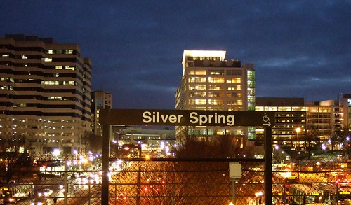 Downtown Silver Spring from the Metro station. Photo by mindgutter
Tysons will have 4 stations, but they will only be able to handle about 40% of the rides of stations at Silver Spring, Bethesda, Rosslyn, and King Street. Matt Johnson at Track Twenty-Nine created an excellent diagram showing how track sharing by Metro lines closer in to the city prevent the same capacities on the outer spokes of the system (except on the Red Line, which does not share tracks with any other line). Even with four stations, the capacity of the line does not stack up to urbanizations in Montgomery County, Arlington, and Alexandria. Can it support an even larger development with less system capacity? Can the already-clogged North Arlington Orange Line corridor support the additional riders with its finite capacity? Optimal success of the Tysons plan would require more Metro capacity such as a separated Blue Line on a new Potomac crossing.
I'm also lead to wonder if this has not contributed to the overall inferior urbanization in Prince George's County. No station in Prince George's has more than 60% capacity because the Green, Blue, and Orange lines all share track inside the District (though the northern section of the Green Line as the potential to do so if the Yellow Line ever runs all the way to Greenbelt regularly). Certainly the County's poor planning policies have contributed to the lack of urban development around virtually all 14 Metro stations, often egregiously, but perhaps lack of capacity has contributed as well.
The stretch of Metro in Prince George's County with the most service, the northern Green(/sometimes Yellow) Line has experienced the most development. Prince George's Plaza Station has probably seen the most. Though not exactly Downtown Silver Spring yet, University Town Center is probably the best example of urban development around a Metro station in Prince George's. Much has been planned for West Hyattsville, College Park, and Greenbelt, though little has come to fruition. New Carrollton, which will have added capacity once the Purple Line comes to town, also has grand plans for development. Stops on the Blue and lower Green Lines, however, are not experiencing as much planning buzz.
I have never heard of any study that implies the impact of station capacity versus development around stations, but it stands to reason that the more capacity, the more successful and robust development can be. The Orange Line corridor might be somewhat of an exception. West of Rosslyn, the Orange line can handle about 60% of the trips Silver Spring or Bethesda can handle. The strip is anchored, however, by Rosslyn, which has the same capacity as Silver Spring and Bethesda.
David Alpert suggested some innovative ways to create more system capacity by separating the Green and Yellow lines and rerouting some of the Silver Line trains. This would help Prince George's County, Tysons Corner, and other locations in Virginia and still be cheaper (in theory) than a separated Blue Line. If Silver Spring, Bethesda, and Rosslyn are models we seek to emulate, station capacity ought to be equivalent of those successful areas.
Downtown Silver Spring from the Metro station. Photo by mindgutterTysons will have 4 stations, but they will only be able to handle about 40% of the rides of stations at Silver Spring, Bethesda, Rosslyn, and King Street. Matt Johnson at Track Twenty-Nine created an excellent diagram showing how track sharing by Metro lines closer in to the city prevent the same capacities on the outer spokes of the system (except on the Red Line, which does not share tracks with any other line). Even with four stations, the capacity of the line does not stack up to urbanizations in Montgomery County, Arlington, and Alexandria. Can it support an even larger development with less system capacity? Can the already-clogged North Arlington Orange Line corridor support the additional riders with its finite capacity? Optimal success of the Tysons plan would require more Metro capacity such as a separated Blue Line on a new Potomac crossing.
I'm also lead to wonder if this has not contributed to the overall inferior urbanization in Prince George's County. No station in Prince George's has more than 60% capacity because the Green, Blue, and Orange lines all share track inside the District (though the northern section of the Green Line as the potential to do so if the Yellow Line ever runs all the way to Greenbelt regularly). Certainly the County's poor planning policies have contributed to the lack of urban development around virtually all 14 Metro stations, often egregiously, but perhaps lack of capacity has contributed as well.
The stretch of Metro in Prince George's County with the most service, the northern Green(/sometimes Yellow) Line has experienced the most development. Prince George's Plaza Station has probably seen the most. Though not exactly Downtown Silver Spring yet, University Town Center is probably the best example of urban development around a Metro station in Prince George's. Much has been planned for West Hyattsville, College Park, and Greenbelt, though little has come to fruition. New Carrollton, which will have added capacity once the Purple Line comes to town, also has grand plans for development. Stops on the Blue and lower Green Lines, however, are not experiencing as much planning buzz.
I have never heard of any study that implies the impact of station capacity versus development around stations, but it stands to reason that the more capacity, the more successful and robust development can be. The Orange Line corridor might be somewhat of an exception. West of Rosslyn, the Orange line can handle about 60% of the trips Silver Spring or Bethesda can handle. The strip is anchored, however, by Rosslyn, which has the same capacity as Silver Spring and Bethesda.
David Alpert suggested some innovative ways to create more system capacity by separating the Green and Yellow lines and rerouting some of the Silver Line trains. This would help Prince George's County, Tysons Corner, and other locations in Virginia and still be cheaper (in theory) than a separated Blue Line. If Silver Spring, Bethesda, and Rosslyn are models we seek to emulate, station capacity ought to be equivalent of those successful areas.
Wednesday, October 14, 2009
Bolling Air Force Waste
Neil at GGW had a great article about the proposal to narrow the Anacostia River (dubbed the McMillian Two Plan) and bring a bit of Paris to eastern DC. If it works and can be done with environmental prudence, I am absolutely in love with the idea. It strengthens the urban fabric of the city, it extends the grid to an underdeveloped but historic part of the city, and it creates more monumental space in the city.
But my favorite part? The plan appears to redevelop the northern part of Bolling Air Force Base. Bolling AFB is an abominable waste of valuable riverfront real estate. Some might argue that the Nation's Capital ought to play host to military facilities. As a former soldier, this is a no-brainer. Of course it should. But DoD property within the District ought to use the space in a manner that is congruent with the rest of the city. Across the Anacostia River, Fort McNair interacts with its urban environment productively and in keeping with the other infrastructure surrounding it. Bolling AFB looks like it could have been built on an empty greenfield an hours drive from the city:
View Larger Map
Does an Air Force base (especially one without an active air strip since 1962) need to take up this much land? Does the utterly suburban housing stock need to sit atop land above one of the most iconic rivers in the world? I'm sure this is no problem at Minot AFB in North Dakota, but the District of Columbia has only 68 square miles. Should almost 5% of it be devoted to isolated, wasteful suburban style land use? Perhaps its time to consolidate Bolling's facilities into something that works better with the city surrounding it, and redevelop Southwest's Potomac waterfront in a manner more suited to its urban environment.
Subscribe to:
Posts (Atom)

