Search This Blog

Thursday, December 31, 2009

New Years Resolution

With the new decade upon us, I have decided to make on very important New Year's resolution: Eat at fewer chain restaurants. Recently I've been discovering local hole-in-the-wall joints like Dumm's in Riverdale Park. Want a decent half-smoke but you're in Silver Spring? Try Quarry House Tavern. When i'm hankering for a sub at work in College Park, do I go to Subway, Potbelly's or Quiznos? How about Jungle Grille on Route 1 instead? Need a quick late-night meal in South Arlington? Try Bob and Edith's Diner.

Apart from the fact that you are likely to get much better customer service and more/better food for the dollar at locally owned establishments like these, they keep money in the community. Panera might be great, but nothing beats the sandwiches at the Parkway Deli in Silver Spring.  And better yet, the define a sense of culture unique to a very small area, like my old haunt the Corner Pub in Four Corners, or the Stained Glass Pub in Glenmont.

The punk rocker in me likes to think that I am keeping my hard earned cash out of the pockets of "the man", but the fact of the matter is it is an economically sound decision, and it enriches my sense of local culture. Ben's Chili Bowl on U Street is a hyperbolic example of how a food restaurant can capture the character of a neighborhood. Some places are late night joints for bargoers, like Tastee Diner in Silver Spring and Bethesda and Steak and Eggs in Tenleytown. And what UMD student has never spent a late Saturday night at Plato's Diner?
Plato's Diner in College Park. Photo from flickr by Steve Snodgrass

I tend to move about the entire region so if anyone has a favorite watering hole, lunch counter, or grease pit that's not of the ilk of McDonalds, Chipotle, TGI Fridays, or Panera, by all means share with me and the rest of our readers. So for one of your resolutions this new year, I encourage you to forgo Starbucks for your morning coffee, and instead patronize a more local institution and keep the money flowing around your neck of the woods.

And of course, Happy New Year, DC!!!

Saturday, December 19, 2009

Snow Emergency: Don't Walk

Having experienced many of my Christmases as a youth in Buffalo, I'm generally nonplussed by big snow storms. This one has confined me to my house, however, and I've been watching the madness unfold on News Channel 8, where they are warning us not to venture outside our houses if we don't have to do so.


Route 1 in Laurel, taken from the front of the Greene Turtle. Plenty of cars were out despite warnings, making pedestrian conditions hazardous. Photo by the author.

Generally, that's very good advice. However, they were showing footage of pedestrians crossing streets and dismissing it as wildly dangerous behavior because, hey, cars gotta use those streets! Certainly driving conditions merit warnings, but why are we chiding the pedestrians instead of the people driving non-emergency vehicles? How are pedestrians expected to stay out of the streets when public services are focusing efforts on clearing roadways while ignoring sidewalks?

Prince George's County Executive Jack Johnson declared a state of emergency because so many county residents failed to heed warnings not to drive. I saw a few of those obstinate drivers on my walk to the Safeway in my neighborhood... which of course was closed. In fact, the only things open in Laurel Lakes Shopping Center were a nail salon (?) and a liquor store. Eventually I found an open 7-11, but suffice to say there was a lack of healthy diet staples. The proprietor, Pankaj, had walked to his store this morning to make sure Laurel Lakes could at least purchase Hot Pockets and yogurt smoothies if nothing else. This really made me wish my neighborhood had live-work units. Not to mention sidewalks.

Despite my lack of healthy food, open shops, and decent pedestrian facilities, at least I wasn't threatened with a gun during a snowball fight. A public gathering in the public realm at 14th and U NW was broken up because... wait for it... a car was hit by a couple of snowballs. The man brandishing the weapon was an off-duty policeman. The message: People don't matter in a snow emergency. Cars do.

Saturday, December 5, 2009

PG Stands for Poor Growth

Now, I like to stick up for my county. I believe that in many ways, Prince George's County has been dealt the short end of the smart growth stick. But the fact is that the county government isn't even trying, and it seems that any smart, transit oriented growth that does occur happens by accident or coincidence.


What puts me over the edge was this Washington Post article in Greater Greater Washington's Breakfast Links. A concrete plant has been approved near Sheriff and Cabin Branch Roads near Fairmount Heights.The Post article points out the multitude of other industrial plants near this site, surrounded on all sides by middle class residential zoning. GGW highlights this concentration, pointing out that the region in majority black. Pushing around non-wealthy minorities is not a new thing Prince George's County.

Cheverly Metro Station. Photo by Genista from Flickr

But what the Post doesn't point out is that the site where this concrete plant has been approved is less than a mile from Cheverly Metro station, one of the most underused stations on Metro. And it's on the same side of US-50 as the Metro station, meaning that useful growth could potentially occur in that area if Prince George's County wasn't treating it as a dumping ground for undesirable industry. It's a location inside the Beltway with easy access to the city and multiple forms of transit, including two Metrobuses that directly serve the site, five Metro stations within two miles (Cheverly, Landover, Deanwood, and Capitol Heights, and Addison Road-Seat Pleasant), and an Amtrak and MARC station at New Carrollton under three miles from the site. This is not the first, but only the latest controversy where PG County has throw its citizens under the bus and tried to drop an industrial plant in residential areas near Metro stations.

This site could be used for transit-oriented development at Cheverly station. It could be a crossroads between Cheverly and Capitol Heights. Instead it is home to an asphalt plant, a recycling transfer station, and a clay mine. And now, coming soon, a concrete plant. These uses would be far more suitably placed along US 50 outside the Beltway just a few short miles away, alas those areas have been blanketed with very low density McMansion developments. Byzantine laws promoting sprawl in PG will continue to force industrial growth in inappropriate places, including Fairmount Heights, one of the oldest black settlements in Maryland.

Prince George's County will not continue to prosper as it runs out of agricultural land while continuing to neglect its valuable inner ring suburbs. Transit investment will continue to be difficult to justify, making it more difficult to fund. And PG will continue to mean poor growth until the county's planning begins to take a look towards the future with regard to land use economy.

Saturday, November 21, 2009

Core Capacity & Freemark's Pink Line

The Transport Politic often showcases unique and clever transit solutions visualized by the site's author, Yonah Freemark. Recently he looked into the WMATA system and made an interesting proposal: a separated Blue Line, and running along it, another investment, a so-called Pink Line. Though Freemark's plan would add invaluable capacity and connectivity to our system, I believe a similar vision could be achieved without building another costly Potomac Crossing. That's not to say we shouldn't, but perhaps a closer term solution might look more like this:


View Pink Line in a larger map

The existing Potomac crossing where the Yellow Line connects Downtown and Pentagon City is underutilized and ought to have it's capacity increased before another crossing is built. This alternative combines the cross-Arlington connectivity that Freemark envisions without the circuitous route back through Rosslyn. This investment could be increased even more if the Green and Yellow Lines could be separated downtown, which might prove cheaper than the Blue Line separation. Another advantage would be that this line could just be an extension of the Silver Line, which would eliminate the need for a new line color.

New track miles are most valuable in the core. Unfortunately, they're also generally the most expensive new track miles. But the benefits to the entire region are huge across the entire system, making it a worthwhile investment. And it's about time we started considering "the rest of Arlington" more a part of the core.

Tuesday, November 3, 2009

A Car Crash Hits Home

I got word last night that the star basketball player from my high school was killed in a traffic accident on the B-W Parkway. I didn't know him on a personal level, only from being a freshman going to basketball games and seeing him lead the team to a win over powerhouses like DeMatha. But it hits home a little more when you know the person involved in the car accidents that take lives all too often on our region's roads.

Last week when swine flue deaths in America topped 1,000, the President declared a national emergency. Meanwhile, we have grown to expect 35 times that number of deaths on our roads every year. So much was made of the Metro accident this summer, as it should have been. But 9 people were killed. How many people have died this year on the Beltway alone? This is a dangerous paradigm to accept as a part of our daily life.

Thursday, October 29, 2009

Playoffs? Playoffs?!!

Posts have been increasing lately, but I somehow managed to get my football squad into the playoffs with out 2-6 record. Excuse the Jim Mora reference in the title.

We're now practicing at our home field under the lights (which makes a huge difference this time of year) because there are fewer teams practicing. Funny, it makes the program smaller and thus better served by the community it represents. The players have a much easier time getting to practice, and team moral has improved quite a bit. Just one more reason I decry the robust, "big box" approach to youth sports that the suburbs have been taking these days.

Monday, October 26, 2009

Imagine the Green Line North Extension

Monday night, Prince George's County voted on its transportation master plan update. I would have attended, but I wonder if the vote and public meeting was intentionally held on an evening where the Washington Redskins Monday Night game at FedEx Field in Landover would make traffic unbearable for northern (urbanism friendly) Prince George's County residents to drive to (highway friendly and transit inaccessible) Upper Marlboro. It's just conjecture, but I would not put it past the county government.

The master plan calls for the creation, extension, or widening of several highways throughout the county, allowance for greenfield development outside the Beltway, and some other Cold War-era fixes to Prince George's transportation problems. The counties ample highways have been described to me by my coworkers as "the only thing worth visiting in Prince George's County". As a resident, I disagree wholeheartedly, but it is hard to dispute that many people use the B-W Parkway, I-95, US-50, MD-4, MD-5, and Indian Head Highway as through routes to get to "nicer" exurban communities in Howard, Anne Arundel, and Charles County.

The master plan did, however, propose many transit improvements. Most notably (for a Laurel resident like me, anyway) is the Green Line extension proposed through Beltsville, Laurel, and on to Fort Meade. The county's proposal for this extension doesn't cater directly to greenfield development like older proposals for the extension that followed I-95 to MD-32 on a circuitous route through southeastern Columbia en route to BWI. The route I have envisioned below follows the CSX corridor in Prince George's County, as indicated in the master plan. If the Green Line is extended to Fort Meade, it would probably look a lot like this:


View Green Line Extension in a larger map

Stations:
Beltsville (Baltimore Avenue and Powder Mill Road)
Muirkirk/Konterra (Baltimore Avenue at Muirkirk Road)
Laurel Lakes (Cherry Lane between Baltimore Avenue and MD 197)
Laurel (Main Street at First Street)
Savage/Annapolis Junction (Brock Bridge Road at Dorsey Run Road)
National Business Park (MD 32 and National Business Pkwy)
National Security Agency (MD 32 and Canine Road)
Fort Meade Main Gate (MD 32 and Mapes Road)
Odenton Town Center (Odenton Road and Morgan Drive)

Fort Meade is the largest job center in the state of Maryland, and it is currently unserved by transit.This train extension would enable reverse commutes from Washington, DC and the Route 1 corridor while facilitating transit oriented development along Route 1. Servicing Fort Meade also would meet some of the transportation challenges that presented by the BRAC's relocation of 5,700 jobs to Fort Meade; Metro access to the bases facilities would eliminate the need for highway widening at the massive job center in Central Maryland. The existing transit on the corridor, the MARC Camden Line, suffers poor service because it shares tracks with the CSX freight trains, does not serve Fort Meade, and has not induced any transit oriented development. This alignment would most likely overcome those shortcomings and better integrate northeastern Prince George's County into the urban fabric of the DC Metropolitan area.

Saturday, October 24, 2009

Google Maps

This week Google Maps began using a new symbology on its maps.line features and place names are now outlined/shadowed, making the maps much easier to read. The new maps are more aesthetically pleasing, professional-looking, and sharper at every scale:


View Larger Map


View Larger Map

They actually remind me of the maps put out by Alexandria Drafting Company (ADC), the local standard in road atlases for a good long time.

Friday, October 23, 2009

Suburbane

Today I stopped in Calverton to fill up on gas. Much to my surprise, the Sunoco station on Cherry Hill Road offered "NBC at the pump", a TV screen with news and entertainment snippets. I had to sort of chuckle at the combination of two uniquely suburban inventions.

I often wonder what of our American toys were popularized or invented because of suburbanization. I've opined in the past that youth sports rose to prominence because of the suburbs. But the popular axiom "it takes a village to raise a child" is virtually lost in isolated, homogenized suburban culture. My mother, who grew up in a Sicilian ghetto in the West Side of Buffalo back when it was a thriving industrial city, used to bemoan the amount of television I watched growing up. As a pre-adolescent, however, I had few other choices for any type of sensory stimulation.

The Northwest Branch ran along the eastern edge of my neighborhood in a steep wooded valley. Despite the hiking path running through it, I was not allowed to play down there because I could get hurt or abducted and there would be no one around to help. Acres of wooded wonder just blocks from my house, and I couldn't utilize it. I was not allowed to walk along or cross University Boulevard for safety reasons. I was allowed to walk home from school along University Boulevard, as well as cross over the Betlway, but that of course was under the watchful eye of a twelve year old wearing an orange patrol belt. These two restrictions confined me to the Franklin Knolls and Montgomery Knolls subdivisions, which included two outdoor community pools, an elementary and a middle school, a synagogue-cum-Baptist church, and a nursing home. Oh, and I almost left out the acres of colonials, ranchers, and cape cods arranged in a hilly, illogical road network.

Newer, shinier suburbs sprouted up in outer Silver Spring and other towns by the late '80's, leaving few children my age in my neighborhood. It was mostly empty-nesters like the holdover Jews from before the synagogue left, the old Greek, Italian, Armenian, and Irish Catholics who moved in at a time when out neighborhood was still connected to a Catholic parish, before the Beltway partitioned it. We might have moved out in the early '90's when the neighborhood really started going down hill. Many of my neighbors did. These were the neighbors that had somewhat prestigious government jobs, like my old next door neighbor the Secret Service Agent. My father fell into this category, but tragically he passed away in 1992, and with three of my siblings in college, my mother decided to stay put.

By that time, I was older. I had slightly more freedom. But any semblance of "community" that existed in the Woodmoor shopping center or the Four Corners area a mile down University Boulevard had long since been replaced by generic strip mall shops. No satisfaction of place there. I also was discouraged from riding the C2 and C4 buses because of "bus people". (My mother eventually convinced me to drop this prejudice that I learned in school, and in high school I became a "bus person"). While most of my friends had a Nintendo or a Sega Genesis, my mother refused to let me and my younger brother partake in video games. Video games are also quite practical in the suburbs. If I could immerse myself in Super Mario Brothers 3 for a couple hours a night, it would fill the void where I should have had a sense of place. Lack of video games led to me talking incessantly on the telephone.

Alexander Graham Bell once said that one day there would be a telephone in every major American city. It's easy to see how he would grossly underestimate his invention before the society was partitioned, isolated, and homogenized into suburban culture. The satisfaction of human interaction could be feigned through talking on the telephone, and later through its successors, the internet and the cell phone. Yes, these inventions have been quite useful and successful across the world. With over four billion subscribers worldwide, cell phones are considered the fastest propagating technology in the history of mankind. But the rise popularity of phones, like television, video games, and the internet, for better or for worse, is likely the product of the suburb induced loneliness that so many Americans suffer, completely unaware of the shortcomings of their environs.

Back in Buffalo, where many of my cousins live, one can still purchase a 4 bedroom single family house for under $7000. My aunts and uncles fled the West Side to McMansions in Williamsville and Amherst. The butcher on the corner of my grandparents' street is currently vacant. And Buffalo continues to spread itself thin. If you haven't recently moved to the most far flung, newly built suburb, you live in an undesirable area.

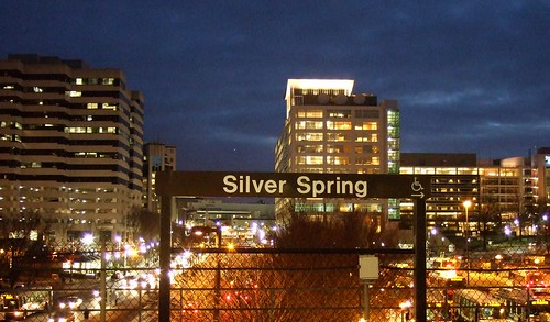
Meanwhile, Franklin Knolls made a bit of a comeback recently. My older sister now lives there with her family. The neighborhood owes its recovery in no small part to its proximity to Downtown Silver Spring and its revival. Our region has dropped that deleterious paradigm. Georgetown, where my older brother slummed with gutter punks in 1987, is now one of the most desirable and prestigious neighborhoods in the region (to the tune of I'll-never-be-able-to-afford-it). Georgetown was built 250 years ago for beauty and comfort, which back then came from sense of place. over time, it remained a memorable place. It became dignified and urbane, so much so that when the flight from the city occurred, those charms didn't abandon it. And in the flight back into the city, Georgetown immigrants would easily settle in to the timeless, memorable environment. In Franklin Knolls, my nephews will be far less likely to need television, video games, and telecommunications to find sense of place and social satisfaction like I did when I grew up there.

As for those vast mazes of colonials and cape cods in Silver Spring, they're slowly getting sidewalks, crosswalks, mixed use development, and better integration to their surroundings. With urbanization, I believe an area becomes more dignified, more memorable, more urbane. With suburbanization... well, I guess the only word to describe it is suburbane.

Monday, October 19, 2009

Transit Capacity

Last month I criticized the plan to scale back Tysons Corner because of the need for increased freeway capacity. The more I think about it, the more merit I see in the notion that a revamped Tysons Corner will be desperately transit-starved. Freeways, however, are not the panacea. The plan to urbanize the region's most prominent edge city will bring thousands more jobs and residents to the area. Even if the area becomes more self contained, it will require much greater capacity for transportation in and out of the area's densest job center.

Downtown Silver Spring from the Metro station. Photo by mindgutter

Tysons will have 4 stations, but they will only be able to handle about 40% of the rides of stations at Silver Spring, Bethesda, Rosslyn, and King Street. Matt Johnson at Track Twenty-Nine created an excellent diagram showing how track sharing by Metro lines closer in to the city prevent the same capacities on the outer spokes of the system (except on the Red Line, which does not share tracks with any other line). Even with four stations, the capacity of the line does not stack up to urbanizations in Montgomery County, Arlington, and Alexandria. Can it support an even larger development with less system capacity? Can the already-clogged North Arlington Orange Line corridor support the additional riders with its finite capacity? Optimal success of the Tysons plan would require more Metro capacity such as a separated Blue Line on a new Potomac crossing.

I'm also lead to wonder if this has not contributed to the overall inferior urbanization in Prince George's County. No station in Prince George's has more than 60% capacity because the Green, Blue, and Orange lines all share track inside the District (though the northern section of the Green Line as the potential to do so if the Yellow Line ever runs all the way to Greenbelt regularly). Certainly the County's poor planning policies have contributed to the lack of urban development around virtually all 14 Metro stations, often egregiously, but perhaps lack of capacity has contributed as well.

The stretch of Metro in Prince George's County with the most service, the northern Green(/sometimes Yellow) Line has experienced the most development. Prince George's Plaza Station has probably seen the most. Though not exactly Downtown Silver Spring yet, University Town Center is probably the best example of urban development around a Metro station in Prince George's. Much has been planned for West Hyattsville, College Park, and Greenbelt, though little has come to fruition. New Carrollton, which will have added capacity once the Purple Line comes to town, also has grand plans for development. Stops on the Blue and lower Green Lines, however, are not experiencing as much planning buzz.

I have never heard of any study that implies the impact of station capacity versus development around stations, but it stands to reason that the more capacity, the more successful and robust development can be. The Orange Line corridor might be somewhat of an exception. West of Rosslyn, the Orange line can handle about 60% of the trips Silver Spring or Bethesda can handle. The strip is anchored, however, by Rosslyn, which has the same capacity as Silver Spring and Bethesda.

David Alpert suggested some innovative ways to create more system capacity by separating the Green and Yellow lines and rerouting some of the Silver Line trains. This would help Prince George's County, Tysons Corner, and other locations in Virginia and still be cheaper (in theory) than a separated Blue Line. If Silver Spring, Bethesda, and Rosslyn are models we seek to emulate, station capacity ought to be equivalent of those successful areas.

Wednesday, October 14, 2009

Bolling Air Force Waste

Neil at GGW had a great article about the proposal to narrow the Anacostia River (dubbed the McMillian Two Plan) and bring a bit of Paris to eastern DC. If it works and can be done with environmental prudence, I am absolutely in love with the idea. It strengthens the urban fabric of the city, it extends the grid to an underdeveloped but historic part of the city, and it creates more monumental space in the city.

But my favorite part? The plan appears to redevelop the northern part of Bolling Air Force Base. Bolling AFB is an abominable waste of valuable riverfront real estate. Some might argue that the Nation's Capital ought to play host to military facilities. As a former soldier, this is a no-brainer. Of course it should. But DoD property within the District ought to use the space in a manner that is congruent with the rest of the city. Across the Anacostia River, Fort McNair interacts with its urban environment productively and in keeping with the other infrastructure surrounding it. Bolling AFB looks like it could have been built on an empty greenfield an hours drive from the city:

View Larger Map


Does an Air Force base (especially one without an active air strip since 1962) need to take up this much land? Does the utterly suburban housing stock need to sit atop land above one of the most iconic rivers in the world? I'm sure this is no problem at Minot AFB in North Dakota, but the District of Columbia has only 68 square miles. Should almost 5% of it be devoted to isolated, wasteful suburban style land use? Perhaps its time to consolidate Bolling's facilities into something that works better with the city surrounding it, and redevelop Southwest's Potomac waterfront in a manner more suited to its urban environment.

Tuesday, September 15, 2009

Tysons Should Look North

Montgomery County Maryland has no limited access freeways that lead into DC. There is the Clara Barton Parkway, a limited access 4-lane parkway at the extreme western edge that ferries traffic to Georgetown with few at-grade intersections, but that's it. Nearly one million people live in Montgomery County, but none of them are hopping on a freeway to get to work Downtown in the morning.

I'm not sure if this is a chicken-and-egg issue, but I'm quite sure that this is related to the fact that the Metro's Red Line, which terminates both ends in Montgomery County, has the highest capacity and ridership of any single line. It shares no track with any other lines. Silver Spring and Bethesda have approximately 70,000 residents in each of their downtowns, and yet not a single freeway runs through them. And in each of those downtowns, there is only one Metro station.

Why then, shouldn't Tyson's Corner be able to thrive without freeway widening once it gets its FOUR Silver Line stations? Fairfax County is planning on scaling back its redevelopment because of potential stress on the freeways 40 years from now.

Their rationale is simple: many people will still drive. Well, sure. Especially if you widen the freeways. And especially if the Silver Line is shoehorned through a huge choke point at Rosslyn, where three lines will be sharing one track.

Perhaps Fairfax County should be considering the enhancement of Metro capacity instead of the worrying about freeways. Montgomery County has an assortment of redeveloped edge cities that don't have any freeways connecting their downtowns with DC. If the Beltway is the worry, why not seek to invest in a transit connection between Fairfax and Montgomery Counties?

People drive primarily because driving has been subsidized into being the best option. If Tyson's Corner is looking to progressively remodel the region, perhaps they should think outside the box and reimagine their transit options.

Monday, September 7, 2009

Labor Day Quick Links

August and September are very busy months for me, so it's difficult to keep up with writing original articles regularly. But please, take a look at some of the links to the right, they are all interesting blogs. Here is a sampling.

DCMUD - More, better housing near a Metro station in a rapidly improving part of the city: Deanwood

GreaterGreaterWashington - Track Twenty-Nine's Matt Johnson has written three spectacular series on freight and passenger rail in DC, station motifs on Metro, and the naming conventions for streets in the District of Columbia

And Now, Anacostia - How soon before Anacostia has streetcars?

Southeast Socialite - Never mincing words, she comments on a critique of Marion Barry, and concern about Eleanor Holmes Norton's lack of responsiveness to public queries.

Bloomingdale (For Now) - Clarifies the location of a section of 7th Street being renamed in honor of the father of go-go

Fairfax Suburbanista - Fairfax City is suburbanizing its Old Town with suburban townhouses. I wonder why they don't just try a traditional plot of townhouses?

WalkLaurel - It's a new website that explains forthcoming pedestrian and traffic improvements in the city of Laurel

Just Up The Pike - Photographs of the ICC construction through an area where several people lost their homes for the sake of the project.

Baltimore Inner Space - Discusses the "low hanging fruit" plan for the Red Line

The Overhead Wire - Discusses the George W. Bush Presidential Library and its ironic proximity to transit

Extraordinary Observations - Are Whole Foods' high prices worth a boycott? Rob argues NO.

DC Sports Bog - While admitting to being on the wrong side of history, Dan Steinberg attempts to douse some of the fire over the Redskins ticket scandal.

Hope you check a few of these articles out. Hope everyone enjoys Labor Day in the seat of the free world.

Friday, September 4, 2009

Baltimore Yellow Line Boondoggle

GGW's breakfast links yesterday had a troubling article at the bottom. The Central Maryland Transit Alliance wants to prioritize extending Baltimore's Yellow Line light rail to Columbia over extending the Green Line subway to White Marsh. I can't even begin to express how dumb of an idea this is.

The Green Line extension will hit developed areas in a large city with a burgeoning centralized train system in place. This is smart. The Yellow Line extension will connect Columbia to downtown Baltimore on a very long, very circuitous route that by-passes Fort Meade, the largest employment center in the state of Maryland.

Baltimore City needs transit connections. It needs an expanded system. It needs a centralized system. A Yellow Line extension would bolster businesses in Columbia and Towson. These are decentralized locations. A Green Line extension would bolster more centralized business districts like the Belair Road and Harford Road corridors. These are centralized areas. Baltimore has been decentralizing for fifty years, and it's not working.

From Columbia, the Yellow Line would take 42 minutes to get to BWI Airport, and then another 27 to get to downtown Baltimore. An hour and nine minutes to get from Columbia to Baltimore. The northern section of the Yellow Line is actually a good idea, connecting several colleges along a main thoroughfare through the city proper. But the southern portion is as circuitous and useless as the current plan for the CCT in Gaithersburg.

CMTA, if you want light rail connecting Columbia to the city, why not push for the US-29 light rail project that was once promised to run from Silver Spring to Columbia? A direct route to the city, not a circuitous one, that hits several established communities along the way is what Central Maryland Transit Alliance ought to be seeking. I don't know how long Dan Reed's alignment (linked above) would take to get from Columbia to downtown DC, but I bet it's faster than 69 minutes.

And if Maryland does decide to run light rail further away from Baltimore, can you at least make some effort to hit the 50,000+ job center at Fort Meade before it is completely choking the region with traffic? I bet you a rail right-of-way that a lot of those employees live in Columbia.

Wednesday, August 12, 2009

You Have To Play To Win

This is a follow-up to last week's post on youth sports.

Silver Spring is a wonderful town by virtue of the dynamic population. I believe it is rare to find a town as diverse. But with the good come the bad.

There are about 300 boys who play football for the Silver Spring Saints. A good portion of them come from single parent households, many others have two working parents. Ironically, since my last post, my team has lost two players who are unable to find transportation to the practices and games. One of those boys played in our program last year, and had been concerned about avoiding gangs in his school. With a single working mother and no extra curricular activity this fall, it raises my concern for him.

I have also been humbled by the immense sacrifices some parents and players make to participate in these programs. Two years ago, a player for my team took two buses to get from school to football practice, and another two to get from football practice back home to Rockville. All in all, every night he had practice was an additional four hours of transportation and walking along unsafe roads. An hour and a half each way between Silver Spring and Rockville on the bus. His single mother had no car, and they relied on coaches to get to and from games. At the time, there was no program in Rockville for which he was eligible to play, and he chose Silver Spring over one other program where he could take the bus to practice from his school.

Many families scrape to come up with the fees to play in a well-organized league. These fees generally run around a couple hundred dollars, and fundraisers and donations are often used to help out families that might not otherwise be able to afford them. When transportation has a negative impact on a child's ability to engage in constructive activities, these children will become isolated and be far more likely to become absorbed into unfavorable activities. No matter how much money is raised, fundraisers and donations will never safely help a young man get to and from our football field. Because of this, how many children will be unable to play youth sports in our region? I know about a handful that had to quit. I'm quite sure there are many more who were never even able to consider it.

Tuesday, August 4, 2009

Youth Sports and the Automobile

It's August, the time of year where I return to my favorite volunteer activity coaching youth football in Silver Spring. Youth sports, despite my lack of athletic prowess, were a big part of my childhood and were probably the only thing that kept me reaching the age of 20 with any semblance of physical conditioning. To a suburban child, youth sports will offer exercise and teach social integration in a safe environment.

My 2008 squad.

Exercise is a valuable commodity in the suburbs. You don't burn many calories from the passenger seat of a minivan. The extreme, of course, is Saratoga Springs, where a student was recently punished for riding his bike to school. The policy against biking to school is of course disguised in the name of safety. Social integration is also more valuable in the suburbs. Suburban children grow up cloistered in pods that effectively segregate socio-economic classes from each other. And despite the marketing, the suburbs are not the safest place to be a kid. So a program that offers exercise, social integration, and safety ought not be undervalued, be it football, swimming, ballet, or whatever.

Are youth sports a rare positive side effect of suburbanization? The Mid Maryland Football League has 26 programs spread out over Montgomery, Prince George's, Anne Arundel, Howard, Baltimore, Frederick, and Carroll Counties, and could never survive without the suburban infrastructure. I used to think youth football could not survive without it at all.

***

The Silver Spring Saints, for whom I coach, are one of the oldest youth programs still in existence in the DC area. When I played on this team as a youth, however, it was Saint Bernadette's, a Catholic Youth Organization program. CYO football went under in 1995, however, and the Silver Spring Saints rose from the ashes, playing their home games at Saint Bernadette's field. When It was Saint Bernadette's, however, the program had two teams with about 23 or so players per team. At its peak, the CYO had 40 or 50 such teams in Montgomery, Prince George's, and DC, and they were broken into geographic-based divisions. It was the premier youth football program in Maryland for decades.

When the Silver Spring Saints joined the Capital Beltway League in 1995, the one-time parish-oriented program had to struggle to field teams in six weight classes, effectively tripling the size of the program overnight and drawing in players from a much larger area. As it struggled with finding enough players, the notion of playing games close by started to disappear. Montgomery Village, Clinton, Germantown, and Bowie were now the away games as opposed to other small teams in Silver Spring, Wheaton, and Rockville. This season, the Saints have joined the Mid-Maryland League to escape the poor organization of the CBL. They are now required to field 12 teams. Many of them will only have about 15 or 16 players. (For those of you not familiar with the sport, there are 11 on the field at a time. An NFL team has 53 players. 24 is an ideal number at the youth level)

I love the Saints organization, and what it does for young men between the ages of 6 and 14. Growing up in a single parent household, it gave me male role models, goals, and a sense of belonging that every boy should experience. But in the time between when I played and now that I coach, it has gone from a "mom and pop" program belonging to a community organization to a "big box" program. The parish still has a strong influence on the program, which in my opinion has kept it about the players and not about championships and egos (though we win our share of games).

No, it's hard to imagine youth football now without cars and giant parking lots at each field, where 12 games are played by each program every Saturday and teams drive as many as 80 miles to play each other. But it hasn't been that way throughout the history of the Silver Spring Saints. For their very first game 58 years ago, the first 12 Saints played Saint Micheal's of downtown Silver Spring, two miles away from Saint Bernadette's. To get there, they took a Capitol Transit Bus.

Thursday, July 30, 2009

Imagine the Beltway at New Hampshire Avenue

The Beltway is a dangerous road full of daunting lane shifts and bottlenecks that bring the ire of even the most seasoned drivers. The area around its junction with I-95 receives a lot of attention, but the problems on its northern counterpart often go ignored.

Westbound 495/95 is four lanes until the interchange with US-1. Both ramps from US-1 to The Beltway create additional westbound lanes, making it six lanes wide at the 95/495 split. Four lanes continue westbound. The ramps from Southbound 1-95 swell the roadway back to six westbound lanes. One lane splits off as an exit for northbound New Hampshire Avenue. A flyover ramp replaces it, creating a weave-style merge for cars entering the westbound Beltway from NH northbound and exiting the Beltway southbound. After the interchange, the highway quickly bottlenecks from 6 lanes back to four. Sound confusing? Try diving it.

A driver who wants to exit the Beltway at New Hampshire Avenue northbound must cross two lanes of traffic even if they were in the far right lane before the I-95 merger. For drivers wishing to head southbound on New Hampshire, they must still cross an extra lane of traffic and then contend with merging across the cars entering the Beltway.


View NH Av Interchange in a larger map

My idea would be to remove one westbound lane where northbound 1-95 splits off to the north, making the stretch between northbound I-95 and southbound I-95 three lanes. When the two southbound lanes join the Beltway, it will be five lanes wide.

Next, remove the exit to southbound New Hampshire Avenue, eliminating a dangerous merge area. Instead, direct that traffic down the northbound exit to a left turn, much like the Georgia Avenue, Connecticut Avenue, and University Boulevard exits off the westbound Beltway. The intersection at the end of the northbound exit is already signaled, it would only need provisions for left turning (southbound) vehicles.

In addition to making this interchange safer for Beltway drivers, it creates a safer environment for pedestrians on New Hampshire Avenue. Not by much, but it would be a start. But just for kicks, I threw in a small street grid, in hopes that Hillandale may one day be a little more pedestrian friendly. They already have a LEED Gold building, perhaps more positive change is on the way.

Tuesday, July 28, 2009

Circular Logic

Tonight I did a very friendly thing and helped a buddy of mine move from Columbia to Gaithersburg. It's a cumbersome route to drive, but I was determined to avoid the rush hour freeways and see what little remained of the northeastern Montgomery County rural areas on the back roads. It is not actually a bad route, if not for the constant stop-and-go through Ashton, Olney, and Gaithersburg.

Woodfield Road, which is currently being widened, at Fieldcrest Road. This intersection could have been a roundabout, but instead the county has decided to induce more demand along this route. (Photo by thisisbossi)

Most of my route (MD-108 to Fieldcrest Road/ to Woodfield Road/MD-124) was two lanes roads, but these two lane roads would mushroom to as many as seven lanes at major intersections. This phenomenon is obviously to prevent long backups at these traffic lights. And in such suburbanized areas, people are driving to get anywhere, hence the percieved need to prevent such backups.

But I noticed that, even during the end of rush hour, I would sit at a traffic light for as many as 90 seconds without a single other car at the intersection in any direction. This made me think of something I read via GreaterGreaterWashington's Dinner Links a few days back; roundabouts as a traffic solution.

As time goes by, intersections grow wider, adding capacity to these suburban intersections. the stretches between the intersections are often are widened shortly after. I noticed this happening on Woodfield Road during my drive. Once this happens, the overall capacity of the road is increased, which induces demand, ultimately contributing to more traffic.

Perhaps before we widen roads in suburban Maryland, we ought to try putting roundabouts in at these intersections. They would improve the flow of traffic without adding more capacity and inducing more demand. Overtime, this would save billions in construction costs. It would reduce the maximum speeds of the cars driving the routes, making the roads safer. But it would not add more time to the trip. During off-peak hours, it might even speed up trips. Other safety bonuses: roundabouts decrease the number of points for a collision to take place by 75%, and also eliminate people speeding up to make a green light. It would save gas, as the article in the above link mentions, accelerating from a dead stop is the least efficient thing an internal combustion engine can do. This would decrease the need for that greatly. And if Gaithersburg ever decides to return to its once-progressive planning style, it would facilitate pedestrians more safely and efficiently.

The fact of the matter is that this could serve as a solution at suburban intersections anywhere, and even many urban intersections. Once the capacity is added and the demand is induced, however, it would be a lot tougher to implement. So why haven't we started doing this on our two- and four-lane roads? Why perpetuate a cycle of increased traffic when we could more easily perpetuate a cycle of efficient traffic flow on our suburban routes?

Friday, July 3, 2009

Imagine a Better Rail Link to Frederick

I have always hated Interstate 270. Always. It is a little confusing with the local and HOV lanes. It is much, much wider than it ought to be, creating huge bottlenecks in northern Montgomery County and at the Beltway. It is preposterously ugly, unbearably congested, and I feel particularly unsafe driving it. It is, in my humble opinion, very poorly planned. The last thing we need is more of it. But that is what they want to give us.

Lots of people travel this corridor in both directions every day. Frederick County has a population of a quarter million and growing. The Bethesda-Gaithersburg-Frederick corridor has a population encroaching on five times that number, or roughly 20% of the Metropolitan area population. Downtown DC and Frederick are about 40 miles apart from each other. So this is a long corridor with a lot of people on it. A transportation solution must be found.

Obviously MARC's Brunswick Line is not getting it done. Its circuitous route through Brunswick adds several additional miles to the trip. Stops at small stations like Garrett Park, Washington Grove, Boyds, Barnesville, and Dickerson. Only 7000 people are riding this line daily (warning: pdf), and it is pushing its capacity. Even MARC's 2035 plan (pdf) only raise the capacity 26,000 per day (pdf). Meanwhile, between 75,000 and 108,000 vehicles clog I-270 every day. Imagine if we were talking about a solution that was faster than an expanded freeway or an improved MARC.

Widening I-270 is a colossal failure of an idea. Creating a bigger bottleneck at the Beltway for commuters from Frederick is just going to increase the number of cars that will sit on the parking lot that is 270 southbound in the morning. Here is my vision for a rail solution:


View Frederick Line in a larger map

If local transit (light rail, buses, etc.) ferried these commuters to a few stations, the trains could make fewer stops and travel at higher speeds. A system like this, I envision an average speed of 90 mph. Eight stops along the way, that's it. Stops at major transit centers and major suburbs along I-270.

There is nothing on the books for a direct high speed service between DC and Frederick. There are plenty of other transit priorities at this time. And I understand that some people have no choice but to drive to their jobs. I am one of them. But I live six miles from my job. If I am going to subsidize someone else's extra-long commute, I want to do it with a system that will work, not one that will only increase the number of cars that are wasting fuel while sitting idly on a congested freeway.

Thursday, July 2, 2009

Do American Highways Make the Grade?

During my recent travels to Germany, I was surprised and impressed by how much I enjoyed driving on the freeways. This past weekend, I realized exactly what it was that was so enjoyable about them. I drove a giant square from Laurel to Bethesda to Frederick and back to Laurel, on Interstates 95, 495, 270, and 70. I never thought I would say this, but our highways are under-engineered.

The A-6 in Germany above grade with an exit to an arterial road running at grade. Photo copyright David Murphy.

I drove through five different Western European countries on my recent business trip to Germany. The highways in all of them were straighter and flatter than our highways. Because of this, their footprints were much smaller, the lanes were not as wide, and their speed limits were much higher, if there was a limit at all. This placed much of the highway on bridges and in cuts, allowing for far less impact on the local road networks (which was already minimal because European freeways rarely run through cities like our interstates). The terrain of Germany, France, and the low countries is at least as hilly as Maryland's, so it was a very notable comparison between the grading of their freeways and ours.

Interstate 270 to Frederick is one of the straightest highways around DC, but after driving on the Autobahn it was very obvious that there are many more minor curves, and the road tightly hugs every elevation change along the way. The A-6 in Germany, by contrast, tended to remain flat through the dips and rises of the terrain. The sight lines were far greater; I could probably see at least a mile ahead at most points on the freeway. Speed limits were generally 100-130 km/h (62-81 mph) and most of Germany had no speed limit except around major interchanges. (Where Germany has speed limits, they are strictly enforced). Combined with laws prohibiting passing on the right and requiring slower cars to make way for faster cars coming up behind them, I saw little congestion on European highways, even during rush hour, even through construction sites.

On Sunday while driving down I-270 just south of Frederick, traffic slowed to about 20 mph for no apparent reason. Perhaps if this road had been properly graded when it was constructed, they would not be considering widening this stretch (pdf). Adding lanes will only generate more traffic (pdf) and make the bottleneck at the Beltway even bigger. Does this mean we should completely regrade I-270? Of course not. But it does mean that perhaps lack of lanes is not what is making traffic so annoying on 270.

Obviously, grading a highway this way is much more expensive. However, if it facilitates better traffic flow, in the long term it pays off. It pays off even faster when considering that the footprint of the highway will be significantly smaller. More even grading and straighter carriageways will also save fuel. Over time, this will add up to quite a bit of fuel. Perhaps it would help lower our per capita road deaths a little more. Right now the only thing decreasing our highway fatalities is the rising fuel costs. Instead, we allow new sub-par meandering freeways like the ICC wind their way through our rural landscapes without putting the structure into the infrastructure. It is no wonder traffic projections predict that the road will not alleviate traffic on any other area highways.

Am I saying we should tear up and rebuild all of our freeways in America? Absolutely not. But love them or hate them, freeways are the most important part of America's transportation infrastructure right now. Before the inevitable new highway is approved, it should be facing scrutiny over curves and small elevation changes like the ones on existing area highways. It could allow for better connectivity, more efficient land use, and it might even save fuel, money, and lives.

Thursday, June 25, 2009

Imagine A Seperate Green and Yellow Line

Naturally, there has been much written about the terrible Metro crash on the Red Line earlier this week. Had this been a nasty pile-up on the Beltway, we might have heard about it by by this point, we probably would have stopped talking about it by now, and it certainly never would have been international news. It is out of the ordinary, tragic, and was a failure of public infrastructure, unlike traffic accidents, which are usually the failures of individual drivers (we'll forgo the argument that fault may lie in road design). The fact that service disruptions continue on the Red Line is another reminder of this horrible accident. After all, these disruptions have a far greater impact on Metro than a bad traffic accident has on area highways.

If there is an accident on US-29 in Montgomery County, I can drive on Georgia or New Hampshire Avenues. But the stations that were shut down the past couple days isolated eastern Montgomery County from the rest of the Metro System. Originally, I tinkered with a map showing a separated Yellow Line for the sake of greater capacity and more geographic coverage for the Metro System. This week's accident has shown that adding redundancy to the system can be just as valuable as adding capacity.

Realizing the need for more redundancy on the system in the wake of this tragic crash is not an original idea. The Purple Line would obviously create alternate routes throughout the system. The Purple Line is both necessary and long overdue, however separating the Yellow and Green Lines would add capacity to existing track, much like separating the Blue and Orange Lines. In the case of the Yellow Line, it would allow for increased capacity on its Potomac River Bridge. If separated, the entire Green Line and the Yellow Line north of Pentagon would have the same capacity as the Red Line.

Here's what I would do with a separate Yellow Line:


View Separate Yellow Line in a larger map

This alignment is not 100% original either. Bringing Metro to North Capitol Street and Georgia Avenue is in no way a new idea. In these cases, however, people seem to want it for the geographic coverage, and not the additional capacity or system redundancy. Coverage is good, it brings transit to a new area. Capacity and redundancy, however, improve the entire system.

Perhaps I added a few too many stations, but they are just suggestions. While this would add service to the North Capitol Street and Georgia Avenue corridors, it would add redundancy to both the Green and Red Lines via Silver Spring, Georgia Av/Petworth, Union Station, and L'Enfant Plaza.

If this line existed already, the station closures on the Red Line might only have meant an additional transfer for Montgomery County commuters instead of the shuttle services to which Metro resorted after the crash.

Monday, June 22, 2009

First Car Trip Back in the US, I Witness a Bike Accident

My first day back in the United States, the very first car trip I take (after jump starting my car, God help you if you don't drive them for 60 days) Just as I am acclimating myself back to American roads, I slammed on my breaks. The Ford Mustang driver in front of me had hit a cyclist. I did not see exactly what happened, but I did note that it occurred as the driver of the Mustang was pulling his car onto 198 from a curb cut entrance to an apartment complex.

The boy was okay, a couple nasty legions, but the bike was ruined. I offered my phone number and got the heck out of there, partly because I was in a hurry, and partly because I didn't want to take anyone's side int this one. After all, I didn't actually see what happened. The Mustang operator was polite and offered assistance, but when they you (probably about 19 or so) wanted to call the police, both occupants of the Mustang and another driver who had stopped after the incident insisted that the cyclist was at fault.

Again, I did not see the actual accident, but I can tell you for sure that on MD-198 in Laurel and Maryland City, the planners of the road were probably at fault. 198 is a six lane highway wrought with curb cuts. The sidewalks are widely traveled, but are only about four feet wide. And, in typical Prince George's and Anne Arundel County fashion, there are no bicycle lanes.

Ironically, as I was driving down the road, I was thinking about the best way to write about my recent travels in Europe and how easy it is to get around without a car. This was a sobering reminder of where I live, and how unwelcoming a place it can be. unless, of course, you are in your car.

Saturday, June 20, 2009

Back In the States

I have returned from Germany (the university town of Darmstadt, to answer previous inquiries) with a renewed sense of appreciation for the cities of both Europe and the United States. I will probably have several tales to tell about my travels on the Audobahn, local tram system, high speed trains, and airports.

The E-25 in Belgium. Photo copyright Dave Murphy.

It dawned on me that today marks a year of running this site (although there have been several obvious periods of lull) I have been most fortunate to have a good number of followers and I wanted to take the time to thank them, even the ones who don't often agree with me. This has been a fun and worthwhile extra curricular activity for me.

Naturally, while in Europe, I took advantage of the walkability and the ample mass transit. But what really surprised me was that I fell in love with the freeway system. I didn't drive often, mostly only on day trips to neighborhing cities, but Germany's Audobahn and European freeways in general are fun and exciting to drive. One thing in particular I noticed was that the expressways, often only two lanes in each direction, have much smaller footprints than interstate highways, and much less traffic. They are generally straighter and flatter than interstates, which allows the carriage lanes to be slightly narrower and the travel speeds to be higher (unlimited in Germany!). It made me wonder, for example, if the Beltway through Montgomery County might be able to survive with three straight, flat lanes instead of four lanes curving and weaving along Rock Creek.

Another thing I liked about the expressways were the ample underpasses. In the rare few areas where the expressways traversed an urban area or even a small town, the street grid was not sacrificed to make way for the new freeway. In Luxembourg, I noticed that it was common for freeways to tunnel underneath entire towns, something probably more affordable in a country as affluent as Luxembourg. The parts that run through forest or farmland are more engaging to their surroundings, making the drive much more scenic and pleasurable than say driving I-95 between Washington and Baltimore. Often in wilderness areas, bridges of vegetation would go over the roads to allow wildlife to pass across the highway. I know these exist in the US, but they were seemingly ubiquitous in the Ardennes Forest. In addition to being functional, they ad a bit more scenery to the highway.

Expressways rarely run through cities, however. They are connected by arterials that cross the freeways outside the cities. In the center cities, there is usually little if any vehicular traffic at all. Most cities that I visited have large pedestrian-only areas, but areas that are on the street grid. In Darmstadt, the main two streets drop below the center of town and intersect underground at a stop sign, a rather exotic layout by American standards. All of this made way for various layers of pedestrian, bicycle, and transit routing, roads often sharing all four modes of transportation.

Driving in general is not as dumbed down. driving through towns or even on the expressways is not quite as intuitive as it is in America. It makes American roads seem overengineered, oversigned, and generally dumbed down for drivers. Interestingly, Germany has far lower incidence of fatalities on the road compared to the US. The entire time I was in Europe I only saw a single traffic accident, whereas it is not uncommon for me to see two while driving the six miles from my house to work here in Maryland. Anecdotal evidence that our overengineering of roads results in drivers paying less attention to what they are doing.

Another great design of European Freeways: they focus your attention at a point on the horizon. Naturally, the narrower streets, usually lined with three storey buildings, direct attention straight ahead. But the expressways were often flanked closely by trees. One Expressway in the Netherlands is lined by 100-foot tall rows of trees, almost like a grand hallway welcoming you onto the freeway. In addition to looking nicer, I believe that this focuses the eyes forward and therefore makes driving that much safer on the road.

I found getting around Germany, France, and the Low Countries to be very easy on all modes of transportation. I was quite surprised to be so taken with the highway system. More posts will come as I get settled back in to the groove here at home. Thanks again for making the last year of blogging so enjoyable.

Monday, May 4, 2009

Update From Germany

I am staying in a medium-sized city of about 120,000, or about the size of Columbia, MD. Any other similarity to Columbia ends there.

The city is very ethnically diverse, with lots of Turks, Africans, Russians, Irish, Americans, and Koreans, as well as countless others. It is mostly middle to lower middle class. The city is connected to the Audobahn by a spur. No freeways run through the town, and only one runs by it, with two lanes in each direction. The width of that entire freeway is barely more than a third of the footprint of I-95 in Howard County.

There is a light rail train with a complimenting bus service, all of which lead to a rail station with IC train service, meaning if I step out of the front door of my apartment, I can walk 100 feet to a tram station and get anywhere in Europe without getting into a car, taxi, or airplane.

The entire city is also covered in bike lanes. They have their own traffic signals seperate from cars and pedestrians. Their lanes cross into pedestrian sidewalks about as often as cars have to share lanes with buses and streetcars, which isn't much.

There is very little crime, people walk around care free and confident virtually all parts of the city at all times of day.

My (American government) job requires me to drive daily. The city streets are 2 meters (about six and a half feet) wide and rarely more than one or two lanes in each direction, if that. The automiobiles of residents are parked in courtyards. At least half the street parking is metered. Iäd say I've never had trouble finding aparking space in town, but I have never driven anywhere in town because I generally walk when I am not working.

Since I have landed in Europe, I have yet to see a single car accident, and I have driven over 1000km in two different countries. I have also not been in a single traffic jam that was not construction related.

The down is distinctly separated from other towns by large tracts of farms and forests. Virtually all buildings are

The city center is closed to automobiles except taxis. It is about a square mile of apartments above shops and businesses, including a shopping mall that is two blocks from the nearest legal parking space.

Best of all, I have been in my apartment for only two weeks and I am on a first name basis with my grocer, the proprietors of four restaurants, the staff at two bars, three of my neighbors, and the gentlemen who run this internet cafe. By contrast, I have lived in Laurel for five years and the only people who know my name are three of my neighbors and my barber.

I am not exactly staing in Mayberry, either. This is a very blue collar industrial town in Central Europe. There are no skyscrapers, no large business headquarters, and no attractions you are likely to find in most guidebooks. If anything, this is a sub-standard European town by comparison to the others I have visited. But the quality of life here is phenomenal.

This experience really makes me stop and wonder what places like Columbia, MD are doing wrong. Columbia certainly boasts a wealthier population that here. But this town has more parkland, more greenspace within walking distance, less traffic, less crime, and a community of people that actually know each other.

This would be an interesting litmus test for many of us: How many people in walking distance to your house know your name? For me, 4 in Laurel, and 14 here. That is the difference of living in a community focused on itself.

Monday, April 20, 2009

Imagine Europe

I'm going to be in Europe on official business for the next two months. Getting ready for this trip has contributed to light posting lately, but it is likely that I won't be doing much posting at all until June. If I can, I'll try and sneak a post or two in while I'm over there.

I'm currently reading James Howard Kuntsler's Geography of Nowhere, and I'm sure that it will help appreciate the differences between American and European cities, architecture, and transportation. I'm looking forward to sharing when I return sometime in June.

In the mean time, take advantage of the DC spring weather, support your local sports teams and concert venues, and get to know the city!

Tuesday, April 7, 2009

Imagine Grosvenor

I have often heard the question as to why Montgomery County's western Red Line has not enjoyed the vibrant urbanism or Arlington's Orange Line. There are several reasons for this, of course. The Red Line's stations are much further apart and further from the downtown core. MD-355 does not have the supporting road network that Wilson Boulevard enjoys. MD-355 also has several obstacles to maintaining urban continuity, such as the Georgetown Preparatory School campus, The Naval Medical Center, Rock Creek Park, and the Beltway.

But the constant comparisons between the two areas have perhaps driven Montgomery County to try to live up to the Orange Line. The White Flint plan has been taking effect in recent months, complimenting the 2007 completion of Rockville Town Square. But these two developments are islandscompared to the continuous row of urbanism in Arlington. It will be difficult to fill in the gaps, as the Red Line's stations are further apart, but it can be done.

Which brings me to Grosvenor, at the southern end or Rockville Pike. It is an important station, as it is the western terminus for half of the Red Line's rush hour trains, and thus recieves more service than any station to the north. It serves Strathmore Hall, MoCo's prominent center for the performing arts. But don't expect to get dinner nearby the idyllic odieum, there is nowhere to eat in walking distance. In fact, apart from some town houses, some apartments that would make LeCorbusier hot and bothered, and a couple of huge private school campuses, there isn't much near Grosvenor station. There is, however, ample space.

The Georgetown Prep campus (one of the oldest in America) is a solid obstacle against integrating TOD around Grosvenor to the planned urban fabric of White Flint, but it could grow them much closer together, and make Grosvenor a bit more of a desination stop. Surface parking replaced with parking garages, a more continuous street grid, and a couple bistros near Strathmore Hall might make this possible. It could also make the Metro station more accessible to the nearby Garret Park community. As it stands, several nearby amenities in walking distance are inacessible to pedestrians because of the overt suburban design of the area. not the least of these amenities are the two high schools practically touching the station.

Here is what I imagine for a road network that would support this sort of development in Grosvenor:


View Larger Map

Unfortunately, I presume that the station's location at a major interstate junction (I-270 and I-495) would be expected to have enormous parking requirements. Given the affluence of the area, however, I wonder if this parking could be consolidated into garages so that a walkable development could emerge. I also fear that this would be nearly impossible to accomplish without the destruction of a lot of housing stock, primarily because of the wasteful land use of the existing developments, which are laid out with the towers-in-the-park mindset. Unfortunately, the "park" in towers in the park is usually automobile parking.

Grosvenor will probably never see anything quite this urban, but hopefully someone will invest in the ample dead space, taking advantage of the Metro station and performing arts center. Perhaps a high end restaurant could become the hot reservation on performance night. Until then, Grosvenor will just be a questionably placed station at the junction of Rockville Pike, the 270 Spur, and the Beltway, not a destination station.

Friday, April 3, 2009

Stupid Growth: Palisades

Early this week, DC Mud profiled a new development finally going for sale in Northwest. The post captures the "McMansion" feel of the development, which is at the intersection of Foxhall and W, in the shadow of Georgetown University. This development has quick access to Georgetown, Rosslyn, and Downtown. It is even a quick drive to the Beltway. This was the best and most lucrative use of land these developers could come up with?

Worse yet, this sets a dismal precedent for the rest of the city. Ryan Avent confronts the absurd 46 4500-to-9000 sqf houses by comparing this development with the District's requests for the Brookland neighborhood to embrace greater density while just across town prime land is being wasted in such a gaudy manner (or should I say gaudy manors?)

There are differneces between the two areas, of course. Most notably, Brookland is next to a Metro station and Palisades is not. However, to borrow a phrase from my fellow GGW contributor, areas like these in the favored quarter ought to be increasing in density, if not socio-economic diversity. Neighborhoods like Palisades, Berkley, Foxhall, Colonial Hill, Wesley Heights, American University Park, and Kent ought not be held to a different standard than neighborhoods like Brookland, Anacostia, SW Waterfront, or Petworth. As these areas grow, the absorb more density. Palisades, however, appears to be immune for some reason.

Don't get me wrong, I know Washington, DC is a capital city, the most important in the world. Foreign dignitaries, ambassadors, policy makers, and other VIP's need to live here, often with greater requirements for security than most people. However, high end neighborhoods like Cleveland Park, Kalorama, Woodley Park, and Dupont Circle house many such VIP's in a form much more conducive to the city's urban fabric. The book Suburban Nation argues that more traditionally designed neighborhoods usually offer better security due to the more prevalent street activity and human presence. Tucked-away low-density developments like this one offer less "eyes on the street", provide more empty spaces and hiding places, and tend to have much longer emergency response times.

We don't need enormous high rises popping up over Whitehaven Parkway, but 17,000 sqf properties with enormous "estate homes" will ultimately only serve to partition Palisades from the rest of the city socially and politically. The wealthy and the privileged certainly have a right to live in higher quality housing stock, but in an urban setting, that sort of development ought to be constructed practicing more responsible land use.

Monday, March 16, 2009

A Big Box Tale

The massive parking lot of the College Park Ikea. Photo from Flickr by technotheory

When I moved into Laurel in late 2003, it seemed as if the city's primary industry was furniture sales. I found the jewel of the bunch, Carolina Furniture. I purchased the bulk of the furniture for my hew house at Carolina Furniture, then located on the corner of Main Street and Rt. 1. It was a small business, but had a very helpful staff and one of the best selections I have ever come across, especially impressive considering the modest size of the store. I loved it. I bought a couch and a love seat for half the price of what the Laurel Marlo (prominently located at Rt. 1 and Contee Road) was offering me for just the couch!

Then came the College Park Ikea. I'll admit, as far as big box stores go, I don't mind Ikea too much. But the College Park location was devastating to local businesses.

Carolina Furniture was the first to go. First it moved to an obviously cheaper site in an industrial park off Bowie Road. By early 2006, it had closed up shop. Galaxy Furniture, located on the site where Burtonsville's Dutch Country Farmers' Market was scheduled to move, fell shortly after. Another mile down Rt. 198 was Regency, a huge warehouse-like store located in a strip mall next to a Target. It closed up shop shortly after. Empire Furniture in Laurel Mall went next, followed by another smaller store that briefly opened in the mall. The tiny family-owned shop across from Galaxy closed just a few months ago. Several others have closed throughout the years in the industrial parks between Rt. 1 and the train tracks. Even the Peir One has closed its doors

Currently, Bargain Furniture is going out of business. This store sold scratched or irregular new furniture at a huge discount, and they offered delivery service only on a few select items. I thought this place would never close. It was always crowded with people looking for a deal on another store's rejected items. But today it is liquidating its stock, as you'll clearly see if you drive through the intersection of 197 and 198.

All in all, at least 9 furniture places have closed in Laurel in the last three years. The only furniture place left in Laurel is mega-chain Marlo, the only store in Laurel I've never recommended because of the poor service I recieved there when purchasing my furniture. All of them were either independent or small chains. I'm sure our recession has played a large part in shutting down these stores, but I can't help but think there were almost a dozen furniture stores before Ikea and now Laurel is down to one or two.

Ikea's iconic 200 foot sign visible from the Beltway for a mile in either direction draws people in to its acres and acres of parking. While the upper level features furniture, the lower level has all kinds of housewares, much like your average Wal-Mart (though of much better quality, generally). The store even features a Swedish cafeteria and a child day-care center. The furniture, however, is do-it-yourself. It is difficult at Ikea to find the country-style furniture I prefer. All the furniture is self-assembled. And no matter how friendly and courteous the staff at the store may be (they tend to be rather hard to pin down), you are one of thousands of shoppers. If you don't buy it, the next person will.

When I bought my living room and dining room sets at Carolina Furniture, everything was delivered and (if needed) assembled at my house at no extra charge. A year later, I took some Army buddies there who had just been stationed at Fort Meade. The sales rep recognized me immediately, even remembering my name and what I had bought. But in Laurel, it appears, those days are long gone. If I want to buy furniture locally, I have to stand in a long line at Ikea or get ripped off by Marlo.

Thursday, March 12, 2009

Light Posting Lately; The Metro Vision Update


Apologies for the light posting lately. I have been working a recession-induced second job, and much of my transit-nerd time has been devoted to poking around in Google Earth tweaking my Mass Transit Vision. I don't have much graphic design experience (read: I have none) and I'm slowly and painfully trying to learn how to use Inkscape, so it will be a while before I can post. it.

Shown right: a very early concept sketch.

Since I have gotten quite a few inquiries on this project, I thought I'd share some information. First of all, it won't be something we're likely to see in my grand-children's lifetime. It would probably cost a trillion or more to construct, and it would have far more capacity than this area could support with its current infrastructure and population. I haven't measured its current length, but I know it would be over 500 miles of track. I'll even go so far as to say it would be irresponsible to even study may of the proposed changes.

The concept I'm working has a core system with thirteen (!) lines, none of which share any track (i.e., separated the Green, Yellow, Blue, Orange and Silver lines from each other) so as to maximize capacity. There are six heavy rail and seven light rail/street car lines, a couple of the latter are spurred at the ends. I extended every single end of every existing and planned heavy rail line, though mostly only a station or two here and there. There are also several infill stations, particularly on the new separated routes. The light rails incorporate plans like the Anacostia Light Rail, the Columbia Pike transitways (both in VA and in MD), The Purple Line, and other DC streetcar proposals. There are two Purple Lines, in fact, both of which loop around the city (the Silver Spring-New Carrolton is the outer line). Much of it is completely unfeasible because it would require a fantastic amount of expensive tunnelling, right-of-way acquisition, engineering, and construction.

I expanded on MARC and VRE (but removed the Camden Line) and removed some of the smaller stations, treating them more like an integrated express service. Most of the smaller stops (like Riverdale and Clifton) were replaces with light rail stops. I put four Metro Lines at Union Station and likewise concentrated rail traffic to other MARC/VRE nodes like Silver Spring, L'Enfant Plaza, Rockville, New Carrollton, and King Street to emphasize their role as express lines.

Shown right: a later concept.

Also included in this plan are five supplemental services. In Maryland, the Corridor Cities Transitway, a series of light rail or BRT lines through Montgomery County (which I called Ride-On) and a light rail loop through Southern Maryland. In Virginia, I threw in a series of light rail/BRT lines for Fairfax and Prince William Counties, as well as an Aerotram along the "Techway" corridor from Shady Grove in Rockville to Dulles International Airport.

I have always felt like others' transit visions lack service in Prince Georges County and River East, so there is a concentration in those areas. I placed transit stops in close-in traditionally planned communities like Hyattsville's Arts District, Takoma Park, Old Town, and other places.

Denser areas that are poorly planned (Seven Corners, Tysons, Eastern MoCo, etc.) received lots of transit assuming they would be redeveloped into more transit oriented areas. Parts of the system are very far flung (Columbia, Fort Washington, South Riding, Woodbridge, Gaithersburg, Odenton, etc.)

I don't know if I'll include them initially, but I also have an integrated plan for Frederick, Annapolis, Baltimore, and the Atlantic Beaches.

Shown right: the current iteration of the project.

Basically, my goal was to visualize a Washington Metropolitan area that could support a population at least twice its current size, while allowing most of the city and closer-in region to comfortably live without a car. Hence its infeasibility. It has been a fun and interesting project so far, even if it has been overkill.

If anyone has the free time to teach me Inkscape, I would be much obliged, and would gladly provide a meal in exchange. Sadly I lack the graphic skills of the many other transit visions that have inspired me to embark on this project.

So please bear with me as I work my two jobs and attempt to get this into a nice readable map for everyone.