
Military bases dot the landscape all around the Capital region. This is a unique presence, as many cities in America are largely defined by the one or two military bases near their boundaries, cities like Fayetteville, NC; Pensacola, FL; Kileen, TX; Norfolk, VA; and even San Diego, CA. Washington, DC, however, is home to the entire Federal Government, so the fact of a few military bases is pocket change in comparison. among the more prominent is a WWI-era base halfway between DC and Baltimore called Fort George G. Meade.
Nestled at the northeast corner of the junction of the Baltimore-Washington Parkway and MD-32, Fort Meade is by far the largest single job center in the state of Maryland and, after Downtown and Tysons Corner, the third largest in the metro area, and this does not account for National Business Park, a huge complex of government contractor buildings right across the B-W Parkway. Fort Meade is home to tens of thousands of military personnel from all five branches, plus retirees. It houses several major Army units, including the Defense Information School, Defense Courier Service, and the US Army Field Band. The Environmental Protection Agency has a large facility, and let's not forget about the National Security Agency, which housed over 30,000 jobs according to James Bamford's 2000 book Body of Secrets. No doubt that number has increased in recent years. Additionally, 5,700 jobs are being relocated to Fort Meade in the Base Relocation and Closure.
The continued growth of the base is of great concern, considering the institutional problems within the defense department when it comes to planning policy. The Pentagon, for example, sits atop two lines of Metro, yet it still has the largest surface parking lot in Arlington County. Fort Meade's total surface parking rivals (if not overtakes) FedEx Field's. This is particularly alarming considering the surface parking's negative effects on storm water runoff into the adjacent Patuxent Research Refuge (to the point where the NSA has an entire section devoted to it on its website). But the base's planning priority? Two 18 hole golf courses to "maintain soldiers' quality of life".
Surely with all these jobs, thousands of residents, and an explosion of growth in the near future, there must be some kind of transit node on the base, right? Not really.
The base is served by a single bus, a 24-seater that runs only twice in the morning and twice in the evening and serves only portions of the city of Laurel to the NSA's main gate. Various agencies on the base offer shuttles that run a few times a day from the Odenton and Savage MARC stations, which are two and five miles from the NSA main gate, respectively, and each three miles from the nearest regular base gate. It is literally illegal to walk any of those routes, as they are largely along MD-32, a freeway of interstate standards. Even servicemen living on base are likely to commute by car, as the base is so spread out that it is a long walk from any of the housing to any of the jobs on post, including almost all of the shopping and recreation amenities.
The first thing I did when I got stationed at Fort Meade? Buy a car. Sure, I wanted a car to go home and visit my family regularly. But I would not have been able to attend my morning physical training without a car. And this was when I lived in the battalion barracks!
So what do you care about a base 20 miles outside of DC?
Consider that a traffic nightmare reaching the base would have a major impact on transportation between Baltimore and Washington. The economic impacts of the resulting disconnect between the two cities could be drastic. Ryan Avent considered the positive impacts that a high speed rail between DC and Baltimore would provide. clogging the highways between the two cities would likely have the opposite effect.
I have often considered Fort Meade an ideal place for the Baltimore and Washington rail systems to meet. I know many detractors consider it wasteful to run the system all the way out to Fort Meade. But smaller jobs centers in Chantilly and Reston, similarly unserved by transit currently will be getting Silver Line service within a decade. And transportation implications in northwestern Fairfax County do not affect passage between two major cities. Other bases involved in the BRAC, such as Andrews AFB, Bolling AFB, Fort Belvoir, and Bethesda Naval Medical Center, have all had plenty of proposals thrown around to improve transit access to the bases (in some cases, like Bolling and Bethesda Naval, increasing existing transit efficiency). Fort Meade has not, despite the unique opportunity of potentially being able to serve the base by two major cities' transit systems. To alleviate traffic at enormous (50,000+) job centers, connector shuttles from commuter rails (i.e. a necessary modal shift) just won't do the trick. Perhaps for a Metro station, the NSA could donate some of it's 900+ acres of parking.
But today, long before ground will ever be broken on any kind of rail connections, wouldn't it at LEAST be appropriate for Fort Meade to receive some sort of express bus service from Greenbelt Metro? Perhaps more regular service from towns like Columbia, Laurel, Odenton and Annapolis? A bus system for the base itself so that a young GI doesn't have to waste his first few paychecks on a new car?
It blows my mind that 18 year old privates are not allowed to drink alcohol, but they are expected to be mature enough to finance, purchase, insure, and properly operate their own heavy machinery, which they may legally store on base free of charge. Shame on Army bases across the country, but particularly Fort Meade, which has the resources nearby to outgrow ridiculous and deleterious planning policies. For a service known for moving on foot, the Army's bases certainly don't embrace any mode of transportation beyond the car.
Friday, October 31, 2008
Thursday, October 30, 2008
Home Sweet Home...
I bought my home in November 2003, at the very beginning of the housing bubble. I consider myself lucky. I had considered moving out and renting for a little while when I got out of the Army in 2005, and I wish I had. My house today is worth less than half what it was worth in when I got out of the Army. Thankfully, still slightly more than I paid for it.
I count my blessings that I wasn't one of the poor souls who got wrangled into a sub-prime mortgage. Considering that I was a naive 23 year old Army specialist when I purchased my house, I very well could have fallen for that. So I'm not on the streets, and I am not totally broke. I count my lucky stars for that.
But now I find myself in a different type of bad situation: one where I want to relocate, but I can't. Sure, it's an excellent time to buy. But even the most motivated seller would have a difficult time selling an old starter home behind the strip malls of Route 1. Tonight I realized just how stuck I really am, and I've all but abandoned my goal of moving by next summer, unless I hit the Powerball or find a much, much more lucrative career field.
I bought this house because of my job on Fort Meade (I'm a civilian now, I was in the Army then). I wasn't thinking that I would be here for a particularly long time, and I was hoping to relocate somewhere more convenient to Metro once I got established in my civilian position. Of course, with the minimal transit capacity on Fort Meade, living near Metro would do me little good, though I might be able to take MARC to work once in a while if I'm in a pinch. The 3 mile shuttle ride from the MARC station to my building is long, infrequent, and inconvenient, and doesn't mesh with my later work schedule, but there are days where anything is better than spending half an hour looking for parking in a lot comparable in size to the lot at FedEx Field for a space that is likely to be virtually inaccessible when I get out of work at 9pm and several of the access gates are long closed.
The parking situation alone leaves me bewildered at people who oppose having Metro come out to Fort Meade, where there are 50,000 jobs plus several thousand more across the B-W Parkway (mostly government contractors, not unlike parts of Tyson's Corner). This massive job center has virtually zero direct transit access (very few shuttles from Savage and Odenton MARC stations), and literally thousands of acres of Fort Meade have been converted to parking lots in order to maintain growth.
Alas, I'm a slave to my car, which soaks up so much of my income that I can't afford to invest the money into the house that I would like in order to sell. Not the worst problem in the world, but just another way the bad economy is hurting an average joe.
Tuesday, October 28, 2008
Stupid Growth: The CCC
When the Arc and the Dove landed on the shores of the lower Potomac in 1634, Southern Maryland was as pristine as it had ever been. Beautiful estuaries, diverse flora and fauna,
and verdant landscapes have always highlighted the area, and they no doubt helped contribute to the success of the first European colony in Maryland.
Most recently, parts of Charles, Calvert, and Saint Mary's County have come to look more like the off-the-highway towns I came to know in the remote parts of the Midwest back in my Army days. Car culture, big boxes, and inefficient land use has taken its toll in places like Waldorf and Dunkirk, and the effects are spreading. Vital wetlands in the Potomac and Patuxent watersheds are bearing the brunt of the ecological damage.
And now a new highway is moving forward.
The Charles County Connector. Consider it the baby brother of the ICC. And thanks to the big brother, you're not likely to hear anything about it. I myself have had a difficult time finding up-to-date information on this highway, but I managed to dig up an old National Environmental Policy Act report (warning: PDF).
 I first heard of this freeway through a colleague of mine who is a member of the Maryland Ornithological Society. The group is of course concerned about the outright destruction the vital wetlands of the Mattawoman Creek as well as increasing impervious surfaces that will feed polluted water into the wetlands, home to scores of species of Maryland birds. These concerns are shared directly by the Mattawoman Watershed Society, who is urging people to write the governor in opposition of the plan. In all, the four-mile, $60m highway would require the destruction of 74 acres of forest and 7.5 acres of wetland. Much of the surrounding area is slated for development upon completion of the new road.
Tim Wheeler at the Baltimore Sun's Bay and Environment blog points out that this deleterious construction would be carried out under the guise of the Maryland Smart Growth initiatives. This to me is incredibly bizarre and most frustrating. Obviously, keeping development in the northern portion of Charles County makes sense for a number of reasons. It is closer to DC, there are larger towns (Waldorf, LaPlata) that are already somewhat developed, and there are ample road and utility connections already present. But smart growth by definition would dictate that development would take place in and around those towns, not in brand new developments around them. Smart growth implies LESS use of the automobile, quite contrary to the notion of constructing a highway.
Granted I have only skimmed the NEPA report, but nowhere have I seen any plans for sidewalks, trails, or transit along the highway. Of course, If they are there, they may get canceled for "environmental impact" reasons like the ironic fate of the ICC bike trail.
For those that argue that they need the highway to alleviate traffic in the area, consider the following analogy: building highways to alleviate traffic is like scratching poison Ivy to get rid of the irritation. It will be better for a short while, but ultimately you are only spreading the problem. Perhaps before Charles County partitions and destroys its most valuable resource, denser construction and transit around Waldorf ought to be considered. That's real smart growth. And if they do, perhaps Southern Maryland will keep a bit more of its idyllic charm from getting eaten up by cul-de-sacs and parking lots. And perhaps my friend from work will be able to spot a common snipe on the Mattawoman for years to come.
Friday, October 24, 2008
Crime Rides the Train
I have seen a million things like this since I started reading about mass transit expansion. Ryan Avent pointed me towards this article complaining about crime rising in a shopping center once a transit connection was made in East St. Louis. Mass transit will connect ruffians to places decent people like to shop. Reminds me of the Purple Line. I've established a modest readership of decent people, so I'll subdue my urge to curse like I did back in my Army days.
I'll admit, mass transit can get groups of people to visit areas they might not otherwise visit. Silver Spring is a good example, with its Red Line and ample bus line service, clientele from Northeast DC flocks to the area regularly. Are we to view this as a bad thing?
Fact of the matter is, kids from Northeast flock to down town Silver Spring because there is nothing to do in a good sized chunk of Northeast. Fortunately, Silver Spring is a very diverse area, and only a minority take issue with "bad city people" impacting their quality of life.
This xenophobic and often racist attitude is, in my opinion, largely counter productive. First of all, transit access does not increase crime. It may relocate some of it, but the fact of the matter is that right now, roads could just as easily connect criminals with whatever hangouts much easier than trains do.
Now, what do we do if crime moves into our lovely Christian suburb? You stand up to it, and make it known that it is not tolerated in Bethesda or Silver Spring or Falls Church. Then perhaps that mentality will follow the would-be thugs back to Hillcrest Heights or Deanwood, where perhaps they will be that much less tolerant of crime in their own neighborhood. Perhaps allowing people to take advantage of these wonderful amenities will inspire them to go back to Trinidad or Chillum and demand those amenities in their neighborhood, which might give the kids there something to do, and keep them off of crime. Who knows, maybe one day you'll leave your little upper-middle class bubble in Great Falls or Olney or Potomac and visit the shops at Langley Park or a new restaurant in Benning Ridge.
The change is going on right now in Anacostia, Hyattsville, and Capitol Heights.
But if we as a society are going to quarantine "undesirable" people to the "undesirable" parts of town, we are only guaranteeing that they will remain undesirable.
Besides, who gets to decide what is "undesirable"? Perhaps it is undesirable for lower income residents in parts of the region to be required to spend a good portion of their paycheck on an automobile to get to their job. Perhaps it is undesirable for University of Maryland students to trek a mile to the Metro station because the same type of xenophobia kept the train far from the campus.
I've lived in this area my entire life. Let me assure you that as recent as 20 years ago, there were parts of Georgetown that most well intentioned suburbanites wouldn't dream of visiting. While I was in high school in the mid 1990's, Columbia Heights was considered unsafe, and there were was practically nothing to do there. As recent as five years ago, the US Army banned soldiers at Fort Meade to go to Near Southeast unless they had some kind of official business there.
Without transit, U Street probably never would have recovered from the 1968 riots. NoMa would be just a bunch of empty parking lots. The Rosslyn-Ballston corridor would just be a bunch of derelict garages and warehouses. Rockville Pike would look more like Route 1 in Howard County.
So to Saint Louis, I say stand up to the crime there. Force that agenda on anyone wishing to visit the nicer parts of your town. force them to bring that back to East Saint Louis, and eventually it will be a place you might want to go visit. That's what we do here in DC.
I'll admit, mass transit can get groups of people to visit areas they might not otherwise visit. Silver Spring is a good example, with its Red Line and ample bus line service, clientele from Northeast DC flocks to the area regularly. Are we to view this as a bad thing?
Fact of the matter is, kids from Northeast flock to down town Silver Spring because there is nothing to do in a good sized chunk of Northeast. Fortunately, Silver Spring is a very diverse area, and only a minority take issue with "bad city people" impacting their quality of life.
This xenophobic and often racist attitude is, in my opinion, largely counter productive. First of all, transit access does not increase crime. It may relocate some of it, but the fact of the matter is that right now, roads could just as easily connect criminals with whatever hangouts much easier than trains do.
Now, what do we do if crime moves into our lovely Christian
The change is going on right now in Anacostia, Hyattsville, and Capitol Heights.
But if we as a society are going to quarantine "undesirable" people to the "undesirable" parts of town, we are only guaranteeing that they will remain undesirable.
Besides, who gets to decide what is "undesirable"? Perhaps it is undesirable for lower income residents in parts of the region to be required to spend a good portion of their paycheck on an automobile to get to their job. Perhaps it is undesirable for University of Maryland students to trek a mile to the Metro station because the same type of xenophobia kept the train far from the campus.
I've lived in this area my entire life. Let me assure you that as recent as 20 years ago, there were parts of Georgetown that most well intentioned suburbanites wouldn't dream of visiting. While I was in high school in the mid 1990's, Columbia Heights was considered unsafe, and there were was practically nothing to do there. As recent as five years ago, the US Army banned soldiers at Fort Meade to go to Near Southeast unless they had some kind of official business there.
Without transit, U Street probably never would have recovered from the 1968 riots. NoMa would be just a bunch of empty parking lots. The Rosslyn-Ballston corridor would just be a bunch of derelict garages and warehouses. Rockville Pike would look more like Route 1 in Howard County.
So to Saint Louis, I say stand up to the crime there. Force that agenda on anyone wishing to visit the nicer parts of your town. force them to bring that back to East Saint Louis, and eventually it will be a place you might want to go visit. That's what we do here in DC.
Saturday, October 18, 2008
A Humble Prediction: Fill Up on Election Day
Now, I want to start by declaring that I am independent of any political party at this point in my life. Four years in the Army left me with some pretty conservative values, and going to war twice for the Bush administration left me an utter hatred for the oil trade. So I don't really fit in to either major party.
However, I have been noticing a trend, and it's not as subtle as it was in 2000 or 2004. The best day to buy gas this year will be November 4th. Mark my words. In the last six weeks, the price of gas has gone down almost $1.40/gal at the Exxon near my house. I'm guessing that by election day it will be a shade under two dollars.
Granted, I don't have anything scientific to back this up, but living in Laurel I am a slave to my automobile and I am always on the lookout for the best time to fill the tank. Take that for what it's worth.
Wednesday, October 15, 2008
...Fight For Ol' DC
 Talk of bringing the Redskins back inside District lines is abound lately. Cost estimates for a domed stadium are roughly in the $1 billion range. The stadium would be designed to host all the Redskins' home games with hopes of bringing the Super Bowl or the NCAA final four to Washington, DC in the future.
Let me start off by saying that I am the biggest Redskins fan around. Apart from military a few obligations, I haven't missed watching a Redskins game since the 80's. One of my goals in life is to be well-off enough to get season tickets. I have accumulated a very extensive memorabilia collection. You get the idea.
It is important to point out that the Washington Redskins have been a part of this city since 1937. The team has set NFL attendance records eight years in a row, and it is the third most valuable sports franchise in the world. The team has sold out every home game since 1967. The NFL is by far the most prominent professional sports league today, and the Redskins are the second most valuable franchise in the league.
Which was why I was a little troubled by something I read on Richard Layman's blog regarding the notion of relocating the Redskins' stadium back into the District:
"SPENDING MONEY ON SPORTS STADIUMS IS A WASTE OF TIME....There are an endless stream of reasons that building a new Redskins stadium in the District would be a bad idea, but I must strongly object to this language when approaching this topic. Professional sports are a very, very important cultural institutions for the cities where they exist. Sports institutions are just as large a part of the culture of a city as its cuisine, art, music, and theater. Spending money on sports venues is just as important as spending money on other cultural venues like the Kennedy Center or the Corcoran Galleries.
...NOW IS THE TIME FOR LEADERSHIP.
NOT PANDERING ON RIDICULOUS STUPID THINGS LIKE GUYS RUNNING AROUND IN COLORED UNDERWEAR AND SIMILAR STUFF."
(Emphasis was in the original text)
I was for the Verizon Center. I was for Nationals Park. and I am for DC United Stadium. But as much as I love the Redskins, I cannot foresee any parcel of land where a new Redskins stadium would be a good thing for the city. For starters, this new stadium is going to be larger than FedEx Field, the Redskins current home, a 92,000-seat stadium in Landover. It will also likely be larger than the new Dallas Cowboys Stadium, a 100,000+ monstrosity. Even the most casual football fan knows that the Redskins and the Cowboys are constantly one-upping each other.
So now we are talking about a stadium with almost DOUBLE the capacity of RFK's 57,000. RFK didn't have too much more capacity than National's Park, and Metro could handle the game day rush. I'm not so sure that this would be true if the numbers were doubled. Assuming three quarters of ticket holders (75,000) live outside the District (which I feel may be conservative, but I don't know where to get the numbers on that), that means that on game day, the population of the city swells by about one eighth. This project has absolutely no chance of getting rid of the surface parking that plagues the area, especially considering the significantly larger footprint of the stadium structure.
Football fans are going to drive because football fans are going to tailgate before and probably after the game. This is why they open up parking five hours before kickoff. When I go to a Redskins game, it usually winds up being a 10 hour ordeal. Most of the folks I know have rather elaborate tailgating set-ups. This phenomenon certainly is not unique to the Redskins. Any team, any city, any weather, there will be tailgating. And why not? At $8 a beer and $5 for a bratwurst, may as well have a party outside the stadium in the parking lot. I imagine this also has to do with the fact that venues as large as football stadiums would flood local businesses on gamedays, and therefore you don't see too many NFL stadiums surrounded by commerce like the Verizon Center. The difference between 17,000 fans and 91,000 fans is... well, do the math. Then imagine five or six times as many people cramming into RFD and Fido in Chinatown on game night.
I poked around, and I can't seem to find an inner-city NFL stadium that appears to have a positive impact on the surrounding area. Soldier Field in Chicago appeared to be among the best:
View Larger Map
Lambeau Field in Green Bay didn't appear to have any surface parking around the stadium, but Green Bay is the smallest American city with a major pro sports team. However, if it were possible to build a stadium with that small of a relative footprint, I'm all for it. Unfortunately, the majority of NFL stadiums wind up looking more like Detroit's Ford Field, vast expanses of surface parking in the downtown. Just like FedEx Field, only FedEx Field's parking is effectively in the middle of nowhere.
This raises the question, is the payoff from the stadium worth the bad urbanism? Well, Ryan Avent doesn't think it's such a good deal to begin with. This enormous chunk of land will host 10 football games a year, eight regular season and two preseason. Best case scenario, another two if my Skins suddenly make a run at the Super Bowl. There may be a Super Bowl or two held there, plus a couple of NCAA tournament games every couple of years. Let's also throw in a major concert, like the HFStival once a year. Maybe another major event or two a year that I'm not considering. My most generous estimation gives fifteen events at this venue in one year. Nationals Park hosts 81 Nats games alone every year. As for the Phone Booth, I've seen the Capitals, Wizards, Georgetown Hoyas, multiple concerts, and a three ring circus there. every other day there is a major event at that place.
GreaterGreaterWashington argues that if all this venue will bring is civic pride, $1 billion is too too costly. This place is going to be sitting vacant for 350+ days a year, occupying riverfront property and containing surface parking that will no doubt contribute to pollution in the Anacostia River. GGW points out the National Capital Framework Plan would have a much more positive economic impact on the city. I tend to agree.
Fedex Field is only 12 years old. It is currently the largest stadium in the NFL. It has sufficient parking, it is convenient to highways, it is served by Morgan Boulevard Metro station, and it is at a location close in and relevant to the city. It may not be inside the District, but it is at least inside the Beltway. As I mentioned in the post linked above, the stadium (and the Metro station, for that matter) have not led to any fantastic economic development in Landover, why on earth would it lead to such progress in East End? RFK Stadium never did.
So here it is, coming out of the mouth of the most die-hard Redskins fan on earth: There is no place for a new stadium in the District of Columbia. Perhaps an adjacent site in Landover or
 elsewhere in Pringe George's County (hopefully a little more convenient to Metro), maybe something in Virginia along the Silver Line, but certainly not anywhere in DC. I'd love to see this town host a Super Bowl. But not at the expense of acres of some of the city's most valuable real estate.
PS- if you're at the game on Sunday, I will be tailgating in Green Lot F60. Look for the eccentric guy with the knit cap with the ball on top.
Tuesday, October 14, 2008
Fairfax County In the Red
58.2 million dollars is the total. Huge cuts are being made. Huge budget cuts are being made. Plummeting home values are exacerbating the problem by severely reducing the county's tax base. It's a scary prospect. WTOP reported that the school system is making drastic cuts. NBC's 11 o'clock news said that the county is going to nix new vehicles for county fire, police, and ambulance services.
Fairfax County is one of the wealthiest jurisdictions in the United States.
Something that draws me to the study of urban planning is the way the landscape can affect every other facet of the human existence. I wonder how much more stable property values would be if Tysons Corner already had its master plan realized. I wonder how much cheaper emergency services would be if the county was organized into concise, navigable, interconnected neighborhoods. I wonder how much extra money the average Fairfax resident would have if they didn't need to own a car to make their ends meet.
I will not claim to have anything beyond a very rudimentary rudimentary understanding of economics, nor have I ever lived in Fairfax County, but hearing news like this is somewhat disconcerting, particularly when I find myself being hit by uncertain financial times. I see my state burning money on infrastructural projects that will further encourage a region of people to accept poor choices in land use as the status quo.
Friday, October 10, 2008
Help a Fledgeling Blogger + Morgan Boulevard
I always appreciate the input of all my readers, especially the ones who disagree with me. It makes this project a little more interesting, and it allows me to experiment with some new ideas that might otherwise go unsaid. So I appreciate everyone who (respectfully) shares their opinion, whether they agree with me or disagree.
I have had an interest in urban planning since before I knew what it was. I used to draw maps of neighborhoods when I was a kid as young as six. Unfortunately, I never found the field of study until after I'd already settled into another career. Now I'm trying to position myself for a career switch, so of course I am using Imagine, DC to help me figure out where my interests lie.
Unfortunately, I'm a relative newcomer to blogspot, and I'm having trouble with a few things... my captions, particularly on Flickr pictures (you know, the part where I give credit to the photographer?) keep disappearing once I post the blog. Anyone know how to fix that?
***
So this weekend I had my first experience with Morgan Boulevard Metro Station on the Blue Line. Normally, I'm a tailgater, but this weekend I didn't have a parking pass to the Redskins-Rams (a very frustrating loss, unfortunately) game so I decided to try Metroing it with my friend Walter. Our jumping point was Takoma, a ten minute walk from Walter's house. The ride is about a 45 minute trip with one transfer at Metro Center.
Frankly, I was a little disappointed at how few Redskins fans take the Metro, but I have a couple of guesses as to why. For starters, it is almost a mile walk down Summerfield/Garrett A. Morgan Boulevard. The sidewalks weren't exactly designed to usher tens of thousands of people down to the stadium. The road is fronted by townhouses in a remarkably car-oriented community with no visible retail, astonishingly poor use of areas sitting atop a Metro Station. For Prince George's County, however, it is not nearly as depressing as many other stations (including the stop before it, Seat Pleasant, which is completely surrounded by single family houses).
Next, it is a bit strange walking down a very suburban road through dozens of houses, particularly on the walk back when the stadium is not on the horizon. I felt like I was meandering aimlessly through some distant suburb, not walking between a 94,000 seat stadium and a high speed transit station. I can imagine how that might deter the average football fan from making the walk. Perhaps this is why few other events are held at the venue throughout the year.
At the end of the day, however, I am astonished that more people don't take Metro to the games. With parking passes STARTING at $25, plus time spent in traffic, the casual fan really ought to consider huffing it a mile from Morgan Boulevard. Unfortunately, tailgaters will always have to drive.
Incorporated
As a Prince George's County resident, I tend to focus my posts more on this area not only because it directly affects me, but also because I feel that it is widely overlooked on issues of urban development and sprawl prevention. This is all too common in Prince George's County... Someone gets struck by a car going at a high speed while crossing a street designed to serve cars and not pedestrians. My last post alarmed me when I saw how many roads are becoming freeways thanks to superfluous interchanges here in my home of Prince George's County. It is horrifying.
I have noted that incorporated towns in Prince George's County seem to be significantly more immune to this "freewayification". Unincorporated areas like Largo, Beltsville, and Greater Upper Marlboro seem to get the brunt of the poorly implemented car-oriented development. Certainly there are may be other factors, but perhaps an incorporated town with direct, small scale representation is less likely to be tolerant of a lack of a sense of place in the town.
Baltimore Inner Space posted this piece (via GGW) on Owings Mills, and its egregious display of poor urbanism, highlighted by a fence and 'No Trespassing' signs that keep mall patrons from accessing the Metro station even though the two are adjacent. Owings Mills, like every other town in Baltimore and Howard counties, is unincorporated. There is no mayor or council to petition against such poor urbanism. residents of the Owings Mills area are at the mercy of developers and a larger government that oversees the entire county of three quarters of a million people. Perhaps this is why Largo looks like this and downtown Hyattsville does not, even though Largo is centrally served by Metro and Hyattsville is not. Even when Hyattsville fell into blight, its primary artery, US-1 remained a four lane road with a speed limit of 30, plentiful cross streets and traffic signals.
Beyond DC writes about Prince William County's future plans to upgrade transit and create more walkable town centers. Beyond DC is skeptical of the plan's ability to succeed, but applauds the idea of improving one of the most populous counties in Virginia. There are only four incorporated areas in Prince William; Occoquan, Quantico, Dumfries, and Haymarket (Manassas and Manassas Park are both independent cities but are completely encompassed by Prince William County). I would be interested to see the success of this plan in those areas versus unincorporated areas like Dale City and Gainesville.
Not to say unincorporated towns can't thrive with good urbanism. Silver Spring and Bethesda are prime examples of unincorporated areas that have exercised a very intelligent master plan. Both those areas are among the most popular walkable areas outside the District. Of course, those two areas are atop Metro stations and they are both adjacent to the DC line situated on prominent corridors into the city. Wheaton, while not enjoying the same level renaissance, might be a good example of an unincorporated exception. It too has a Red Line station (home to the western hemisphere's longest escalator), and has been improving steadily for about the last twenty years. I ought to know, I went to high school there.
If the Tysons Corner plan gets off the ground, that will be another unincorporated area that enjoys smart redevelopment. Of course, the sector plan for the area seems to treat the area like an incorporated town (strict boundaries and districts, guidelines and regulations specific to the area, a council to govern the plan, etc). Obviously the existing density and planned metro stations have a great deal to do with this overhaul as well.
My Prince George's County seems to have a clear dichotomy between smartly designed incorporated towns working to improve their walkability and livability and unincorporated areas that are draped with high speed roads, poor pedestrian facilities, big box stores, and a depressing lack of a sense of place. Even my neighborhood, technically outside the corporate limits of the City of Laurel, lacks the sidewalks and curbs present in the neighborhoods to the east, north, and west. Does that mean it would be smarter to incorporate more towns? Beltsville, Chillum, Langley Park, Lanham, Clinton, Suitland, Largo, Oxon Hill, and Camp Springs, should we look into incorporating them?
The mayor of (incorporated) Kensington commented on my MARC post informing me that Kensington too will be making improvements to the downtown. Does a government directly serving a smaller group of people help an area create, grow, and preserve their sense of place? Perhaps the incorporation provides more organization for the residents to vocalize their desire to improve the state of their surroundings. Whatever it is, it will likely ensure that my next house will be in an incorporated town.
Monday, October 6, 2008
Ambitious Transit Advocacy
I really liked a point Ryan Avent made this week:
This is an excellent point, and one that ought to be further explored within the DC metropolitan region. We can build roads to support future development, but rails? Forget it. Furthering this point, Richard Layman had a good post on the sort of fundamental paradigm shifts we will to need to undergo in order to take the economic and environmental burden out of transit provision.
But if we could build rails anticipating future developments, I believe areas such as incorporated, close-in, traditionally-built suburban towns ought to be among the to speculate transit expansions. Incorporated towns because the local government may have a shorter route to approving smarter development around transit, close in so that they are relevant to the heart of the transit system, and traditionally-built neighborhoods because the open connectivity is conducive to residents reaching the transit station. Places like Hyattsville, Takoma Park, Kensington, Falls Church, and Forest Heights ought to be considered for such speculation.
 I have been toying around in Google Earth trying to imagine a transit system for the DC area that would make it easy to live anywhere in the region without a car, much like Manhattan. It is probably not a very feasible system, with 14 lines and 550+ miles of heavy and light rail track, plus the fact that my quasi-scientific formulas for designing my system have no way of predicting ridership or optimal routes. But I'm kind of curious as to why the DC metropolitan area and other cities aren't advocating for such a system that takes cars off the roads.
The extremely ambitious highway plan of half a century ago makes such a system of passenger trains seem rather small. Freeway revolts nixed much of the more detrimental inner city freeways, however much of the freeway infrastructure in our region has come to fruition. Remember, freeways don't necessarily have to be interstates (much like Metro doesn't necessarily have to be heavy rail, it can be light rail)
Below, I've listed the limited access divided freeways of our region (DC, plus Montgomery, Prince George's, Arlington, Fairfax and northeastern Prince William County and Alexandria City) Lengths approximate:
Mostly or completely pure freeway:
I-95 Maryland (College Park to Howard County) 8 miles
MD/DC-295, Balt-Wash Parkway (Anacostia to Fort Meade) 21 miles
I-495, Capital Beltway (loop around the city) 66 miles
I-270 (Bethesda to Frederick) 33 miles
I-95/395, Shirley Highway (Dale City to Downtown) 26 miles
I-295, Anacostia/Southeast Freeway (Oxon Hill to Downtown) 8 miles
Suitland Parkway (Anacostia to Andrews AFB) 10 miles
US-50, John Hanson Highway (Cheverly to Annapolis) 25 miles
US-50, Arlington Boulevard (Merrifield to The Mall) 11 miles
I-66 Custis Memorial Freeway (Gainesville to The Mall) 32 miles
Clara Barton Parkway (Georgetown to Potomac, MD) 10 miles
I-370/MD-200, Intercounty Connector (Gaithersburg to Laurel, under construction) 18 miles
George Washington Memorial Parkway (Alexandria to Great Falls) 15 miles
Dulles Toll Road/Greenway (Arlington to Loudon County) 16 miles
Key Br/Whitehurst Fwy/Potomac River Fwy (Rosslyn to The Mall) 2 miles
US-29, Columbia Pike (Silver Spring to Howard County) 11 miles
MD-4 Pennsylvania Avenue (Suitland to Anne Arundel County) 11 miles
MD-5 Branch Avenue (Suitland to Brandywine) 12 miles
VA-28 Sully Road (Manassas to Dulles International Airport) 21 miles
Montrose Parkway (Rockville) 4 Miles
Rock Creek Parkway (Woodley Park to The Mall) 3 miles
Rapidly becoming pure freeways:
US-301, Blue Star Memorial Highway (Bowie to Waldorf) 26 miles
MD-210, Indian Head Highway (Forest Heights to Accokeek) 11 miles
VA-7100, Fairfax County Parkway (Herndon to Springfield) 35 miles
VA-3000, Prince William Parkway (Woodbridge to Manassas) 16 miles
451 miles of freeway in Washington DC and adjacent counties. Sure makes the downtown sections that didn't get built seem like small apples. This doesn't include "mini freeways" embedded into the traffic system. It does not include the express tunnels on North Capitol, South Capitol, Connecticut Avenue, Massachusetts Avenue, or K Street. Nor do they include spur freeways like the Cabin John Parkway, 270 spur, Spout Run Parkway, or the E Street Expressway. Nor does it include roads that become freeways for short stretches, like Central Avenue in Largo, Military Road west of 14th Street, North Capitol Street north of the Hospitals, or Franconia Road in Springfield. Nor does it include interchanges at non-freeways, like Tyson's Corner, Glenmont, University Boulevard at Route 1, or Kingle Road. Nor does it take into account express lanes, HOV lanes, or exit ramps. I figure all of this combined ought to add up to at least 100 miles.
I'm curious about the percentage of area residents that live within walking distance to fixed transit versus the percentage of area residents that live within walking distance to a freeway or an interchange. I'd be willing to bet that the latter is the larger number. If highways can have their 550 miles of coverage, why not rails?
Perhaps highway advocates threw a bunch of ideas at the wall to see what stuck. Perhaps it was the relentless lobbying. But whatever it is, it is the highway lobby had more ambition than our current transit advocacy currently exudes. If we can emulate one thing from the freeway lobby of the mid-20th Century, it is the ambitious fortitude with which they lobbied for what ultimately became the largest public works project in world history.
I'm not going to settle for a transit system that doesn't allow most of the metropolitan area to survive without an automobile. I'm going to keep pushing for my 550 miles of fixed rail.
The point that highways are built speculatively all the time while transit is not is a very good one, and one which never fails to get my goat. But I think it’s worth emphasizing that speculative transit isn’t really about building lines into the wilderness. It’s about building lines into places people already live in order to take better advantage of valuable land there.
For instance, if we imagine a sunbelt boomtown, it’s easy to see an exurban ring road being built to accommodate “future development.” At the same time, a rail transit system through the downtown area would be nixed in a heartbeat because that area lacked an appropriate density for transit. But transportation linkages shape development whether they’re road or rail. When you fail to use the same speculative criteria for one mode that you do for another, you are making a judgment about what kind of development is appropriate. For decades, government has essentially said that in the overwhelming majority of cases, auto-oriented development is appropriate and nothing else. Considering the effects of that decision, it must be one of the most momentous government interventions of all time.
This is an excellent point, and one that ought to be further explored within the DC metropolitan region. We can build roads to support future development, but rails? Forget it. Furthering this point, Richard Layman had a good post on the sort of fundamental paradigm shifts we will to need to undergo in order to take the economic and environmental burden out of transit provision.
But if we could build rails anticipating future developments, I believe areas such as incorporated, close-in, traditionally-built suburban towns ought to be among the to speculate transit expansions. Incorporated towns because the local government may have a shorter route to approving smarter development around transit, close in so that they are relevant to the heart of the transit system, and traditionally-built neighborhoods because the open connectivity is conducive to residents reaching the transit station. Places like Hyattsville, Takoma Park, Kensington, Falls Church, and Forest Heights ought to be considered for such speculation.
 I have been toying around in Google Earth trying to imagine a transit system for the DC area that would make it easy to live anywhere in the region without a car, much like Manhattan. It is probably not a very feasible system, with 14 lines and 550+ miles of heavy and light rail track, plus the fact that my quasi-scientific formulas for designing my system have no way of predicting ridership or optimal routes. But I'm kind of curious as to why the DC metropolitan area and other cities aren't advocating for such a system that takes cars off the roads.
The extremely ambitious highway plan of half a century ago makes such a system of passenger trains seem rather small. Freeway revolts nixed much of the more detrimental inner city freeways, however much of the freeway infrastructure in our region has come to fruition. Remember, freeways don't necessarily have to be interstates (much like Metro doesn't necessarily have to be heavy rail, it can be light rail)
Below, I've listed the limited access divided freeways of our region (DC, plus Montgomery, Prince George's, Arlington, Fairfax and northeastern Prince William County and Alexandria City) Lengths approximate:
Mostly or completely pure freeway:
I-95 Maryland (College Park to Howard County) 8 miles
MD/DC-295, Balt-Wash Parkway (Anacostia to Fort Meade) 21 miles
I-495, Capital Beltway (loop around the city) 66 miles
I-270 (Bethesda to Frederick) 33 miles
I-95/395, Shirley Highway (Dale City to Downtown) 26 miles
I-295, Anacostia/Southeast Freeway (Oxon Hill to Downtown) 8 miles
Suitland Parkway (Anacostia to Andrews AFB) 10 miles
US-50, John Hanson Highway (Cheverly to Annapolis) 25 miles
US-50, Arlington Boulevard (Merrifield to The Mall) 11 miles
I-66 Custis Memorial Freeway (Gainesville to The Mall) 32 miles
Clara Barton Parkway (Georgetown to Potomac, MD) 10 miles
I-370/MD-200, Intercounty Connector (Gaithersburg to Laurel, under construction) 18 miles
George Washington Memorial Parkway (Alexandria to Great Falls) 15 miles
Dulles Toll Road/Greenway (Arlington to Loudon County) 16 miles
Key Br/Whitehurst Fwy/Potomac River Fwy (Rosslyn to The Mall) 2 miles
US-29, Columbia Pike (Silver Spring to Howard County) 11 miles
MD-4 Pennsylvania Avenue (Suitland to Anne Arundel County) 11 miles
MD-5 Branch Avenue (Suitland to Brandywine) 12 miles
VA-28 Sully Road (Manassas to Dulles International Airport) 21 miles
Montrose Parkway (Rockville) 4 Miles
Rock Creek Parkway (Woodley Park to The Mall) 3 miles
Rapidly becoming pure freeways:
US-301, Blue Star Memorial Highway (Bowie to Waldorf) 26 miles
MD-210, Indian Head Highway (Forest Heights to Accokeek) 11 miles
VA-7100, Fairfax County Parkway (Herndon to Springfield) 35 miles
VA-3000, Prince William Parkway (Woodbridge to Manassas) 16 miles
451 miles of freeway in Washington DC and adjacent counties. Sure makes the downtown sections that didn't get built seem like small apples. This doesn't include "mini freeways" embedded into the traffic system. It does not include the express tunnels on North Capitol, South Capitol, Connecticut Avenue, Massachusetts Avenue, or K Street. Nor do they include spur freeways like the Cabin John Parkway, 270 spur, Spout Run Parkway, or the E Street Expressway. Nor does it include roads that become freeways for short stretches, like Central Avenue in Largo, Military Road west of 14th Street, North Capitol Street north of the Hospitals, or Franconia Road in Springfield. Nor does it include interchanges at non-freeways, like Tyson's Corner, Glenmont, University Boulevard at Route 1, or Kingle Road. Nor does it take into account express lanes, HOV lanes, or exit ramps. I figure all of this combined ought to add up to at least 100 miles.
I'm curious about the percentage of area residents that live within walking distance to fixed transit versus the percentage of area residents that live within walking distance to a freeway or an interchange. I'd be willing to bet that the latter is the larger number. If highways can have their 550 miles of coverage, why not rails?
Perhaps highway advocates threw a bunch of ideas at the wall to see what stuck. Perhaps it was the relentless lobbying. But whatever it is, it is the highway lobby had more ambition than our current transit advocacy currently exudes. If we can emulate one thing from the freeway lobby of the mid-20th Century, it is the ambitious fortitude with which they lobbied for what ultimately became the largest public works project in world history.
I'm not going to settle for a transit system that doesn't allow most of the metropolitan area to survive without an automobile. I'm going to keep pushing for my 550 miles of fixed rail.
Friday, October 3, 2008
MARC =/= Metro
A lot of people criticize me for not liking MARC. I do like MARC, but I don't think it is a viable service to be integrated with Metro, and I think it only truly serves people who live and work along one of the corridors. Since it is not fully integrated with Metro, switching between the two services is an expensive inter-modal shift that deters people from using the system.
MARC's availability is another problem. Right now the system is wildly overcrowded. It only runs during the work week, during the day. The trains are overcrowded, and the availability to add more daily service is hampered by the fact that much of the system shares tracks with CSX and AMTRAK.
What really bothers me about the system is the fact that in the DC Metro area, MARC does not appear to influence transit-oriented development. Sure, some stations have good development, or at least plans for such development: Rockville, Silver Spring, Greenbelt, New Carrollton... of course, those stations all have Metro stations as well.
An excellent example of this would be the Kensington station. Kensington is on the Brunswick Line between Silver Spring and Rockville. Kensington is an incorporated town with a business district adjacent to the train station, but this station has done little to influence pedestrianism like in Rockville and Silver Spring, which have Metro stations. Kensington is merely a confluence of three rivers of cars, with a few office buildings and restaurants surrounded by parking.
View Larger Map of Kensington Lots of Parking fronting traffic gutters
I live on the Camden Line, perhaps the most useless fixed rail line in the region. I'm about halfway between the Laurel and Muirkirk stations. Muirkirk is a middle-of-nowhere station useful only to commuters who drive there from Beltsville. It serves no one. The Konterra development will be just across Rt 1, but it has seemingly little connectivity to the MARC station. It has been implied that Konterra's town center location along I-95 would support a new Metro station along I-95. Laurel is in the blossoming downtown of Laurel, a city of 30,000 people, but the station has little impact on development plans in the city. It seems that more of the development (such as Laurel Commons) has been more in anticipation for a future Metro station a mile or so south on an expanded Green Line.
View Larger Map of Muirkirk Station Office parks and no sidewalks
To make MARC a more viable system, it would require additional tracks along pretty much the entire system. Why not, then, build Metro tracks along the DC, PG, and MoCo portions of the system and connect those areas to the rest of the system with seamless transfers? Leave MARC as it is, a REGIONAL system that gets people between Baltimore, Washington, and Frederick. Heck, add another MARC line to Annapolis. We need MARC, but we can't treat it like a system that integrates areas into the greater transit system of the DC Metropolitan area.
MARC is not a suitable compliment to Metro. It may connect DC and Baltimore, but it doesn't connect Laurel, Bowie, Kensington, and other DC suburbs to the urban fabric of the metropolitan area.
My thoughts on replacing the stations on the lower portion of MARC with Metro:
Brunswick Line: Use the Yellow Line, build a spur at Ft. Totten and run along the Red Line to Silver Spring (Or better yet, run it under Georgia Avenue from Petworth Station to Silver Spring) and then along the Brunswick Line to Rockville.
Penn Line: Instead of terminating the Silver Line at Stadium-Armory, run the Silver Line along the Orange Line to New Carrollton and then extend it up to the BWI stop on the Penn Line. The Silver Line would then connect two major regional airports.
Camden Line: Bring the Green Line up to Laurel. Route One can support the TOD.
Of course this doesn't appear feasible, but as I have mentioned before, I believe our rail initiatives ought to be at least as ambitious as the Freeway Plan of the 1960's. Leave MARC. It is a great redundancy system for traveling between Baltimore and Washington. But instead of giving MARC more tracks, build tracks for a system that is going to effectively enhance the region's ability to develop more environmentally friendly transit-oriented suburbs with convenient transit access.
Wednesday, October 1, 2008
Imagine A Train on the Shirley Highway
 Yesterday i discussed the possibility of putting a Metro-integrated light rail train in the median of Interstate 95/395 in Virginia. Through the magic of Google Earth, I give you what I have dubbed "The White Line"
Shown here starting in Woodbridge and terminating at L'Enfant Plaza. The segment up south of the Beltway runs off the freeway along the heavy rail right-of-way. North of that, the line runs in what is now the reversible HOV lanes in the middle of the Shirley Highway.
This stretch of asphalt is one of the most recognizable routes into the city. Ten years ago, I-395 was averaging a quarter of a million in annual average daily traffic. In the last ten years, added lanes and improved intersections have made it easier for cars to travel on this road. But are we making investments to move the most people along this corridor? Could a train move more people quicker than HOV lanes? I bet it would be worth finding out.
An I-95 Train?
I've always wonder what DC would have looked like if they had built all the freeways that had been proposed in the '60s. I'm glad they didn't, but I do have fun driving on urban freeways like the BQE in New York, the Mass Pike in Boston, or the Southeast-Southwest Freeway here in DC. I gripe about how in DC (and Baltimore, for that matter) Freeways basically dead end in the city, dumping ridiculous volumes of automobile traffic in concentrated areas that ought to be more geared toward pedestrians. Either connect them, or get rid of them.
What is now I-395 was supposed to have connected along the Metropolitan Branch train line and connected to the stub at the I-95 interchange in College Park. Instead, it dead ends on New York Avenue, dumping thousands of cars onto what was intended to be a grand boulevard with vistas to the White House. Many of the funds from those abandoned highway projects were ultimately diverted to Metro. But the highway system proposed was far more in-depth than Metro today. Why didn't we match that ambition with trains?
Frankly, I don't care if the Shirley Highway is backed up. That highway is about six lanes wider than it ought to be anyway. I say, get rid of all those HOV lanes in the middle and add another Metro line, perhaps a light rail. Make it useful. Start it in Dale City, and have it run all along 95 and then 395 in the center lanes, all the way up toDC where it can connect underground to L'Enfant Plaza. Virginia commuters would then have the option to eschew the traffic on the freeway with a different kind of high occupancy vehicle: transit. Those giant empty spaces in the middle of highway exits? Throw parking garages in there. Giant park and rides taking tens of thousands of cars off the road every day.
I am curious to see what a study would say might happen if those HOV lanes were replaced with perhaps a light rail track with seamless connectivity to Metro stations (Franconia, Pentagon, and L'Enfant, perhaps).
Maybe this new line could even fight its way through the city and connect to I-95 in College Park, then head on up to Columbia. Sure it would be a long line, but it would do what ambitious freeway planners wanted I-95 to do: connect the region. Only this would be a far more responsible way of doing so.
Normally, I don't believe transit lines should run completely on freeways. I think freeways stifle the ability to place transit-oriented development around stations. I think a rail running along Rt. 1 in Maryland is far superior to one running along I-95, a parallel freeway a few miles west with no chance for promoting the same kind of good urbanism. But the Virginia portion of the above proposal would ostensibly replace a freeway, the one-way HOV lanes from Woodbridge to DC. Could trans move the same number of people during rush hour? They certainly would move people faster, considering they wouldn't have to suffer through Mixing Bowl traffic... they'd just speed right past it.
I wonder, has this proposal ever been thrown out there? Have such studies been conducted? Could a light rail move as many people as the HOV lanes, or would it have to be Metro, or something of even higher capacity?
Moving on from highways is going to take a plan as ambitious and extensive as the plan that put them here in the first place; a plan that can equal or best the largest public works project in human history. Why not start with superfluous lanes on a highway bringing thousands of people into the city every day?
Subscribe to:
Posts (Atom)


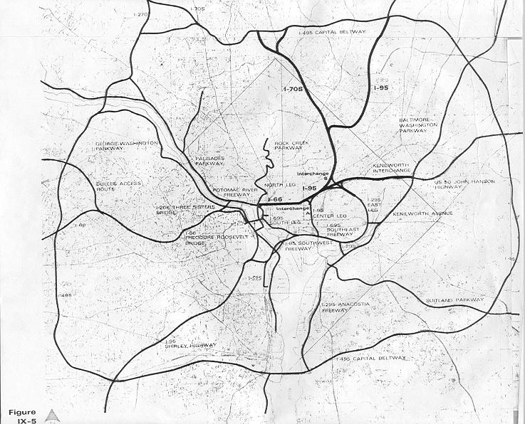