Search This Blog

Showing posts with label traffic. Show all posts

Tuesday, August 17, 2010

An Email

I know posting has been sparse recently as I have been busy with a new job and overwhelmed by selling my suburban house while preparing for a series of temporary work-related relocations. But recently I received an email regarding municipal land use policy that I wanted to open up to a wider debate. Please leave any constructive comments you might have regarding the issue.

S 
do you think it is a good idea, bad idea, or value neutral idea for a small town to amend their ordinance protecting "open spaces" in order to allow for the refurbishing of an existing building to be transformed to affordable senior housing.
(I don't know if "open spaces" is a standard term, but in this case it means land zoned for institutional use and includes areas that have a lot of property such as schools, churches, library etc)

I watched a LONG debate/discussion at a city council meeting and found I'm kind of in the minority in my opinion and wondered what a less biased person with actual knowledge of city plan would have to say.
-s

Dave Murphy 
"Open space" is a very sketchy term. Gigantic empty lawns that nobody uses for anything are often considered "open space". On the one hand, if they can be used for something more meaningful, I'm all for it. If a building or set of buildings reinvigorates the town, absolutely it is a better use of the land, regardless of its use.

A great example in my opinion would be Four Corners, an area we both know and love... When they tore down the Kay Tract to build Blair High School, they demolished acres and acres of "green space". That area was a haven for homeless people and drug activity. It was unpatrolled, unregulated, secluded, and crime-ridden.

But when they tore out all those trees, what arose was a school already too small for its student body despite the fact that it was spread out over twice the real estate of the old school. The main feature that interacted with the rest of the "town" (if one were to consider Four Corners its own town) was not the main facade of the school, not the grand entrance, walkways, side buildings, or even athletic fields; it is the driveways and parking lots that front the school.

It secluded the student body, who for the most parts are residents of Four Corners and downtown Silver Spring, from the rest of the town. Was it a better municipal use of land than a bunch of trees with trash and homeless people? Absolutely. But does it contribute more to the townliness of Four Corners? Barely.

A good side effect was the pedestrian improvements that came along with a 3,200 student school, and Four Corners desperately needed those pedestrian improvements. But despite the fact that it is the most heavily traveled intersection in Eastern Montgomery County (for PEOPLE, not cars... more people move through that intersection than even Georgia and Colesville) no major mass transit improvements came with the school save for maybe a bus shelter or two.

Now consider the lawns providing the setback for St. Bernadette's. That is open space. It is green space. Is it serving the people of Four Corners? Does it serve St. Bernadette's other than to isolate it from the high speed traffic of University Boulevard or the "public school kids" that as a universal community of faith we ought to be reaching out to and embracing? The only thing I've ever used those fields for is stretching out a football team before a game at St. Bernadette's. And in 5 years of coaching and two years of playing, I can count the number of times I've done that on two hands.

Now consider something like this:
http://greatergreaterwashington.org/post.cgi?id=3922

Erik Bootsma, the architect that authored this article, is a Beaux Arts architect and a Catholic. He writes about religious structures often. Here's his website, it's great:

http://beatusest.blogspot.com/

But back to the suburban church being retrofitted... American churches are often gigantic, isolated structures that are monuments to themselves. Whereas in Europe, Cathedrals are the centerpieces of the towns, in America you have junk like the Mormon tabernacle, which only interacts with people driving down the Beltway and in no other way serves as a structural outreach to the community. For all their questionable doctrine, this is actually my number 1 gripe with the Mormon church. They structurally isolate themselves from their surroundings, even in Salt Lake City. But nowadays, every church does that. They move from central locations to wherever they can have the biggest parking lot, assuring that few will walk to their services and ostensibly turning away anyone that does not drive a car.

If St. Bernadette's was to take the lawns in front of the parish and do something useful such as what Bootsma proposed there in Arlington, it would create a community directly affected by the parish rather than isolated from it. And for a religious institution, what better way to attract members than to make the primary structure (the church) the focal point of a community? And as far as traffic on University Boulevard goes, building frontage could slow traffic down, and a more permeable street network could actually relieve congestion there. A train line running up Columbia Pike would be nice also.

As for your case, affordable senior housing is never a bad thing in theory. But what are they building? Garden style apartments with ample parking that will eventually mock seniors who lose the ability to drive? Or a community of well designed buildings that will allow seniors to partake in society without forcing them to drive? In my opinion, the latter serves more use than an open lawn that nobody uses.


Tuesday, March 30, 2010

A Bike Crossing and a Disconnected Street

I drive around the College Park Metro Station a lot. That area is home to one of the most notable examples on Prince George's County's long list of misguided transportation infrastructure disasters. The College Park Trolley Trail crossing at Paint Branch Parkway. Rethink College Park has chronicled the embarrassingly over-the-top markings, signs, and traffic implements to bring notice to the heavily traveled bike path crossing.

Allow me to set the scene: The College Park Trolley Trail runs along the bits and fragments of a disjointed Rhode Island  Avenue between Route 1 and the MARC/Metro tracks. It is a heavily used trail that connects north College Park to the University and the Metro Center, and this crossing is a crucial point on the path. Paint Branch Parkway is a four lane road with a double yellow line. The south side of the road has a sidewalk that goes under the train tracks to the Metro station. The north side has nothing between the train tracks and Route 1 despite several bus stops along the route. The only signalized crossing accessible to the north side of the CPTT is at Route 1, about a quarter mile west. And as mentioned above, there are no sidewalks to get there.

College Park has been trying to get a HAWK signal at the intersection, an option the County dismissed quickly. There is another way to get the crossing signalized, however College Park is likely to foolishly dismiss it: connect Rhode Island Avenue to Paint Branch Parkway.


View Larger Map


The CPTT and Rhode Island Avenue would intersect Paint Branch Parkway at the same place, and the vehicular intersection could receive a traffic signal on which the bike and pedestrian path could piggy-back. This would also improve street connectivity in traffic-clogged College Park. But that's exactly why the idea will probably never be explored. It would attract cars into the neighborhood, a notion that the University and the residents will likely balk at. Never mind the fact that it houses College Park's newest parking garage at Knox Road and Yale Avenue. People won't want through traffic by-passing traffic-choked Route 1 on the narrow, speed-bumpy neighborhood streets.

Prince George's County, like most of the rest of the nation, favors funneling traffic onto main streets instead of keeping a permeable network of interconnected and redundant streets. Usually, this just isolates communities and creates traffic problems. In this case, however, it hurts (sometimes literally) pedestrians and bikers who cannot count on Paint Branch Parkway drivers to obey the 35 mph speed limit or the state law that mandates cars stop at all crosswalks for bikes and peds.

In most other wealthy countries on earth, bikes, cars, pedestrians and transit find a way to coexist together on publicly maintained roads. This separation of modes with a grossly negligent safety situation once again emphasizes that in a country that is already bad at that, Prince George's County finds a way to prove they are one of the worst.

Thursday, January 7, 2010

Coast Guard HQ: 2,000 Cars, No Boats

A historic campus. An idyllic untouched corner of real estate in close proximity to the seat of federal government for a great nation. The headquarters of an esteemed branch of the military and an a department headquarters for a government agency. No nation on earth could improve on a venture like that. But in the United States, we throw in a 1900 space garage.

The United States Coast Guard Headquarters design has been approved. I'm not an architect nor am I capable of eloquently stating my disgust at a coast guard headquarters that looks like a spa retreat off in the woods despite the nearby convergence of two navigable rivers, but I will openly take issue with the 1,973 space garage. It is definitely better than surface parking, but this is a historic site, virgin land with views of the convergence of the rivers, the Capitol, and the monuments. Real estate in America doesn't get more prime than this. And DHS is dropping a greenified Tyson's Corner transplant with a huge garage in the middle of it, complete with a sexed up drainage pond and ample parking.

I've advocated that a campus like this ought to house an institution of higher learning, particularly UDC. To me, that would be the ideal way to dignify that site (Although I don't know what your average UDC student would think about moving into dorms that formerly housed mental patients... but one would think the good people hat DHS and the Coast Guard would have similar concerns!)

I'll admit my reaction is perhaps a bit pessimistic considering that I have not seen an illustration or elevation that contextualizes the complex amongst the St. E's buildings, but with streetcars imminent, location near two Metro stations, and traffic congestion already problematic, a huge parking garage has me worried that this is just going to be another office park like those in Columbia, Gaithersburg, or Tyson's Corner.

The garage is built into a slope visible from Haines Point. Several measures were put in place to minimize the visual impact of the structure, such as putting more of it underground and a green wall system on the northern facade, however on an important site like this with available transit alternatives, I would expect better planning and land use than a green-guilt version of the same disposable crap office box we have all come to know and hate.

Students of architecture, I beg your input on this one. I am at a loss for words. If the Army built something that ugly, I would be even more embarrassed as a veteran than I am when West Point gets annihilated by the Naval Academy in football every December.

Tuesday, November 3, 2009

A Car Crash Hits Home

I got word last night that the star basketball player from my high school was killed in a traffic accident on the B-W Parkway. I didn't know him on a personal level, only from being a freshman going to basketball games and seeing him lead the team to a win over powerhouses like DeMatha. But it hits home a little more when you know the person involved in the car accidents that take lives all too often on our region's roads.

Last week when swine flue deaths in America topped 1,000, the President declared a national emergency. Meanwhile, we have grown to expect 35 times that number of deaths on our roads every year. So much was made of the Metro accident this summer, as it should have been. But 9 people were killed. How many people have died this year on the Beltway alone? This is a dangerous paradigm to accept as a part of our daily life.

Friday, July 3, 2009

Imagine a Better Rail Link to Frederick

I have always hated Interstate 270. Always. It is a little confusing with the local and HOV lanes. It is much, much wider than it ought to be, creating huge bottlenecks in northern Montgomery County and at the Beltway. It is preposterously ugly, unbearably congested, and I feel particularly unsafe driving it. It is, in my humble opinion, very poorly planned. The last thing we need is more of it. But that is what they want to give us.

Lots of people travel this corridor in both directions every day. Frederick County has a population of a quarter million and growing. The Bethesda-Gaithersburg-Frederick corridor has a population encroaching on five times that number, or roughly 20% of the Metropolitan area population. Downtown DC and Frederick are about 40 miles apart from each other. So this is a long corridor with a lot of people on it. A transportation solution must be found.

Obviously MARC's Brunswick Line is not getting it done. Its circuitous route through Brunswick adds several additional miles to the trip. Stops at small stations like Garrett Park, Washington Grove, Boyds, Barnesville, and Dickerson. Only 7000 people are riding this line daily (warning: pdf), and it is pushing its capacity. Even MARC's 2035 plan (pdf) only raise the capacity 26,000 per day (pdf). Meanwhile, between 75,000 and 108,000 vehicles clog I-270 every day. Imagine if we were talking about a solution that was faster than an expanded freeway or an improved MARC.

Widening I-270 is a colossal failure of an idea. Creating a bigger bottleneck at the Beltway for commuters from Frederick is just going to increase the number of cars that will sit on the parking lot that is 270 southbound in the morning. Here is my vision for a rail solution:


View Frederick Line in a larger map

If local transit (light rail, buses, etc.) ferried these commuters to a few stations, the trains could make fewer stops and travel at higher speeds. A system like this, I envision an average speed of 90 mph. Eight stops along the way, that's it. Stops at major transit centers and major suburbs along I-270.

There is nothing on the books for a direct high speed service between DC and Frederick. There are plenty of other transit priorities at this time. And I understand that some people have no choice but to drive to their jobs. I am one of them. But I live six miles from my job. If I am going to subsidize someone else's extra-long commute, I want to do it with a system that will work, not one that will only increase the number of cars that are wasting fuel while sitting idly on a congested freeway.

Thursday, July 2, 2009

Do American Highways Make the Grade?

During my recent travels to Germany, I was surprised and impressed by how much I enjoyed driving on the freeways. This past weekend, I realized exactly what it was that was so enjoyable about them. I drove a giant square from Laurel to Bethesda to Frederick and back to Laurel, on Interstates 95, 495, 270, and 70. I never thought I would say this, but our highways are under-engineered.

The A-6 in Germany above grade with an exit to an arterial road running at grade. Photo copyright David Murphy.

I drove through five different Western European countries on my recent business trip to Germany. The highways in all of them were straighter and flatter than our highways. Because of this, their footprints were much smaller, the lanes were not as wide, and their speed limits were much higher, if there was a limit at all. This placed much of the highway on bridges and in cuts, allowing for far less impact on the local road networks (which was already minimal because European freeways rarely run through cities like our interstates). The terrain of Germany, France, and the low countries is at least as hilly as Maryland's, so it was a very notable comparison between the grading of their freeways and ours.

Interstate 270 to Frederick is one of the straightest highways around DC, but after driving on the Autobahn it was very obvious that there are many more minor curves, and the road tightly hugs every elevation change along the way. The A-6 in Germany, by contrast, tended to remain flat through the dips and rises of the terrain. The sight lines were far greater; I could probably see at least a mile ahead at most points on the freeway. Speed limits were generally 100-130 km/h (62-81 mph) and most of Germany had no speed limit except around major interchanges. (Where Germany has speed limits, they are strictly enforced). Combined with laws prohibiting passing on the right and requiring slower cars to make way for faster cars coming up behind them, I saw little congestion on European highways, even during rush hour, even through construction sites.

On Sunday while driving down I-270 just south of Frederick, traffic slowed to about 20 mph for no apparent reason. Perhaps if this road had been properly graded when it was constructed, they would not be considering widening this stretch (pdf). Adding lanes will only generate more traffic (pdf) and make the bottleneck at the Beltway even bigger. Does this mean we should completely regrade I-270? Of course not. But it does mean that perhaps lack of lanes is not what is making traffic so annoying on 270.

Obviously, grading a highway this way is much more expensive. However, if it facilitates better traffic flow, in the long term it pays off. It pays off even faster when considering that the footprint of the highway will be significantly smaller. More even grading and straighter carriageways will also save fuel. Over time, this will add up to quite a bit of fuel. Perhaps it would help lower our per capita road deaths a little more. Right now the only thing decreasing our highway fatalities is the rising fuel costs. Instead, we allow new sub-par meandering freeways like the ICC wind their way through our rural landscapes without putting the structure into the infrastructure. It is no wonder traffic projections predict that the road will not alleviate traffic on any other area highways.

Am I saying we should tear up and rebuild all of our freeways in America? Absolutely not. But love them or hate them, freeways are the most important part of America's transportation infrastructure right now. Before the inevitable new highway is approved, it should be facing scrutiny over curves and small elevation changes like the ones on existing area highways. It could allow for better connectivity, more efficient land use, and it might even save fuel, money, and lives.

Thursday, June 25, 2009

Imagine A Seperate Green and Yellow Line

Naturally, there has been much written about the terrible Metro crash on the Red Line earlier this week. Had this been a nasty pile-up on the Beltway, we might have heard about it by by this point, we probably would have stopped talking about it by now, and it certainly never would have been international news. It is out of the ordinary, tragic, and was a failure of public infrastructure, unlike traffic accidents, which are usually the failures of individual drivers (we'll forgo the argument that fault may lie in road design). The fact that service disruptions continue on the Red Line is another reminder of this horrible accident. After all, these disruptions have a far greater impact on Metro than a bad traffic accident has on area highways.

If there is an accident on US-29 in Montgomery County, I can drive on Georgia or New Hampshire Avenues. But the stations that were shut down the past couple days isolated eastern Montgomery County from the rest of the Metro System. Originally, I tinkered with a map showing a separated Yellow Line for the sake of greater capacity and more geographic coverage for the Metro System. This week's accident has shown that adding redundancy to the system can be just as valuable as adding capacity.

Realizing the need for more redundancy on the system in the wake of this tragic crash is not an original idea. The Purple Line would obviously create alternate routes throughout the system. The Purple Line is both necessary and long overdue, however separating the Yellow and Green Lines would add capacity to existing track, much like separating the Blue and Orange Lines. In the case of the Yellow Line, it would allow for increased capacity on its Potomac River Bridge. If separated, the entire Green Line and the Yellow Line north of Pentagon would have the same capacity as the Red Line.

Here's what I would do with a separate Yellow Line:


View Separate Yellow Line in a larger map

This alignment is not 100% original either. Bringing Metro to North Capitol Street and Georgia Avenue is in no way a new idea. In these cases, however, people seem to want it for the geographic coverage, and not the additional capacity or system redundancy. Coverage is good, it brings transit to a new area. Capacity and redundancy, however, improve the entire system.

Perhaps I added a few too many stations, but they are just suggestions. While this would add service to the North Capitol Street and Georgia Avenue corridors, it would add redundancy to both the Green and Red Lines via Silver Spring, Georgia Av/Petworth, Union Station, and L'Enfant Plaza.

If this line existed already, the station closures on the Red Line might only have meant an additional transfer for Montgomery County commuters instead of the shuttle services to which Metro resorted after the crash.

Saturday, June 20, 2009

Back In the States

I have returned from Germany (the university town of Darmstadt, to answer previous inquiries) with a renewed sense of appreciation for the cities of both Europe and the United States. I will probably have several tales to tell about my travels on the Audobahn, local tram system, high speed trains, and airports.

The E-25 in Belgium. Photo copyright Dave Murphy.

It dawned on me that today marks a year of running this site (although there have been several obvious periods of lull) I have been most fortunate to have a good number of followers and I wanted to take the time to thank them, even the ones who don't often agree with me. This has been a fun and worthwhile extra curricular activity for me.

Naturally, while in Europe, I took advantage of the walkability and the ample mass transit. But what really surprised me was that I fell in love with the freeway system. I didn't drive often, mostly only on day trips to neighborhing cities, but Germany's Audobahn and European freeways in general are fun and exciting to drive. One thing in particular I noticed was that the expressways, often only two lanes in each direction, have much smaller footprints than interstate highways, and much less traffic. They are generally straighter and flatter than interstates, which allows the carriage lanes to be slightly narrower and the travel speeds to be higher (unlimited in Germany!). It made me wonder, for example, if the Beltway through Montgomery County might be able to survive with three straight, flat lanes instead of four lanes curving and weaving along Rock Creek.

Another thing I liked about the expressways were the ample underpasses. In the rare few areas where the expressways traversed an urban area or even a small town, the street grid was not sacrificed to make way for the new freeway. In Luxembourg, I noticed that it was common for freeways to tunnel underneath entire towns, something probably more affordable in a country as affluent as Luxembourg. The parts that run through forest or farmland are more engaging to their surroundings, making the drive much more scenic and pleasurable than say driving I-95 between Washington and Baltimore. Often in wilderness areas, bridges of vegetation would go over the roads to allow wildlife to pass across the highway. I know these exist in the US, but they were seemingly ubiquitous in the Ardennes Forest. In addition to being functional, they ad a bit more scenery to the highway.

Expressways rarely run through cities, however. They are connected by arterials that cross the freeways outside the cities. In the center cities, there is usually little if any vehicular traffic at all. Most cities that I visited have large pedestrian-only areas, but areas that are on the street grid. In Darmstadt, the main two streets drop below the center of town and intersect underground at a stop sign, a rather exotic layout by American standards. All of this made way for various layers of pedestrian, bicycle, and transit routing, roads often sharing all four modes of transportation.

Driving in general is not as dumbed down. driving through towns or even on the expressways is not quite as intuitive as it is in America. It makes American roads seem overengineered, oversigned, and generally dumbed down for drivers. Interestingly, Germany has far lower incidence of fatalities on the road compared to the US. The entire time I was in Europe I only saw a single traffic accident, whereas it is not uncommon for me to see two while driving the six miles from my house to work here in Maryland. Anecdotal evidence that our overengineering of roads results in drivers paying less attention to what they are doing.

Another great design of European Freeways: they focus your attention at a point on the horizon. Naturally, the narrower streets, usually lined with three storey buildings, direct attention straight ahead. But the expressways were often flanked closely by trees. One Expressway in the Netherlands is lined by 100-foot tall rows of trees, almost like a grand hallway welcoming you onto the freeway. In addition to looking nicer, I believe that this focuses the eyes forward and therefore makes driving that much safer on the road.

I found getting around Germany, France, and the Low Countries to be very easy on all modes of transportation. I was quite surprised to be so taken with the highway system. More posts will come as I get settled back in to the groove here at home. Thanks again for making the last year of blogging so enjoyable.

Monday, May 4, 2009

Update From Germany

I am staying in a medium-sized city of about 120,000, or about the size of Columbia, MD. Any other similarity to Columbia ends there.

The city is very ethnically diverse, with lots of Turks, Africans, Russians, Irish, Americans, and Koreans, as well as countless others. It is mostly middle to lower middle class. The city is connected to the Audobahn by a spur. No freeways run through the town, and only one runs by it, with two lanes in each direction. The width of that entire freeway is barely more than a third of the footprint of I-95 in Howard County.

There is a light rail train with a complimenting bus service, all of which lead to a rail station with IC train service, meaning if I step out of the front door of my apartment, I can walk 100 feet to a tram station and get anywhere in Europe without getting into a car, taxi, or airplane.

The entire city is also covered in bike lanes. They have their own traffic signals seperate from cars and pedestrians. Their lanes cross into pedestrian sidewalks about as often as cars have to share lanes with buses and streetcars, which isn't much.

There is very little crime, people walk around care free and confident virtually all parts of the city at all times of day.

My (American government) job requires me to drive daily. The city streets are 2 meters (about six and a half feet) wide and rarely more than one or two lanes in each direction, if that. The automiobiles of residents are parked in courtyards. At least half the street parking is metered. Iäd say I've never had trouble finding aparking space in town, but I have never driven anywhere in town because I generally walk when I am not working.

Since I have landed in Europe, I have yet to see a single car accident, and I have driven over 1000km in two different countries. I have also not been in a single traffic jam that was not construction related.

The down is distinctly separated from other towns by large tracts of farms and forests. Virtually all buildings are

The city center is closed to automobiles except taxis. It is about a square mile of apartments above shops and businesses, including a shopping mall that is two blocks from the nearest legal parking space.

Best of all, I have been in my apartment for only two weeks and I am on a first name basis with my grocer, the proprietors of four restaurants, the staff at two bars, three of my neighbors, and the gentlemen who run this internet cafe. By contrast, I have lived in Laurel for five years and the only people who know my name are three of my neighbors and my barber.

I am not exactly staing in Mayberry, either. This is a very blue collar industrial town in Central Europe. There are no skyscrapers, no large business headquarters, and no attractions you are likely to find in most guidebooks. If anything, this is a sub-standard European town by comparison to the others I have visited. But the quality of life here is phenomenal.

This experience really makes me stop and wonder what places like Columbia, MD are doing wrong. Columbia certainly boasts a wealthier population that here. But this town has more parkland, more greenspace within walking distance, less traffic, less crime, and a community of people that actually know each other.

This would be an interesting litmus test for many of us: How many people in walking distance to your house know your name? For me, 4 in Laurel, and 14 here. That is the difference of living in a community focused on itself.

Sunday, March 8, 2009

Repurposing Urban Freeways

I have stated several times here that I believe urban freeways have their place in most cities, particularly in cities with lots of industrial and military activity. These are the purposes for which a federal highway system was created.

Unfortunately, these highways were not created for what they are most commonly used to accomplish: commuting. Most traffic congestion is caused by commuting. It occurs in the morning and evening rush hours. It costs trillions in wasted fuel, wasted time, and wasted environment.

What if commuting on highways was illegal?

This is a highly unlikely and rather radical approach to solve widescale congestion problems, and I have no reason to think it would take anywhere in the US right now. But what if urban freeways (like 295 and 395, for instance) were reserved only for transit, industrial (trucks), military, and emergency vehicles? Naturally this would have to come with an unrealistically large scale repurposing of our suburbs, which is why it is obviously not feasible. This hypothetical line of thought could argue a couple of advantages in the case of Washington, DC.

This would mean commuters would need to find alternative means of getting to DC. This would undoubtedly result in thousands of cars being taken off the road. the lack of cars commuting into or through the city would result in less space needed for commuter parking, which could allow more parks, residences, and businesses to be constructed throughout the city. It would likely result in a massive drop in car owners. This would increase the disposable income of area residents who no longer have need to own a car. (I have stated before that for me, this would be about 20% of my take home income). That would result in a higher tax base for the city, making it easier to invest in an expanded mass transit system, perpetuating a cycle that would reverse the negative effects of sprawl.

Industrial and military vehicles would be less likely to use the surface streets. In fact, they could even be outlawed from using surface streets, apart from approaches to the highways. though it might inconvenience some industrial traffic, I imagine that having an uncongested freeway would be an overall benefit for them. I am vehemently opposed to having military traffic running down city streets. To me this is something that they do in Tehran and Pyongyang, not Washington, DC.

Naturally, the drop in gas usage, exhaust, and vehicle miles traveled will be good for our environment. One could even go so far as to suggest that there would be an overall increase in walking, which could lead to better health. But more directly, the decrease in CO2 emissions will have an obvious and immediate impact on air quality.

Freeways are valuable tools of industry in America. They literally shaped the landscape and united the country in a way the world had never seen before. But they have been rendered near useless in much of the country becasue we allow them to be used for purposes which they were not originally intended. Perhaps rethinking the modality of freeways on some level could benefit a the local, municipal, regional, and national landscapes.

Saturday, February 28, 2009

Highway Prejudice

I was reading this WaPo Roads and Rails Q&A session and I noticed a disturbingly high number of people commenting that HOV lanes and congestion pricing was unconstitutional because they discriminate against people who can't find another person to ride with them, and it is unconstitutional to discriminate on public infrastructure.

Oh Really?

I can't take my bike on the Shirley Highway. Are they discriminating against me? I can't even take a mo-ped out there. I sure as hell can't walk along the shoulder. You can't take your car on the Metro. Is that discrimination? Is it discriminatory for trail users to yeild to cars when they cross roads? I'd like them to tell me where controlled usage becomes discrimination, and why.

Now, I'm not endorsing HOV and HOT lanes (and certainly not any new construction of such roads) as any sort of a cure for our traffic problems here in Washington. But this is a very poignant reminder of how entitled we believe are cars should be.

Tuesday, January 13, 2009

How I'm Getting to the Inauguration

Hopefully I'll be over my cold by then, but I do plan on attending the Inauguration, which is now only a week away. But with massive transportation issues that day and estimates as high as 5 million people coming to town, getting there seems to be a scary proposition.

I'll have two out of town visitors that I'm putting up at my home in Laurel. My usual stations of choice are Greenbelt, College Park, Cheverly, and New Carrollton. But considering that the Green and Orange Lines are located on the Beltway, I think I'm going to try a different approach.

I'll be heading to Silver Spring Metro station. Here's why: first of all, the other stations on that end of the Red Line (Forest Glen, Wheaton, and Glenmont) will certainly see a great deal of volume, but I do not believe that the gobs of out-of-towners will be flooding them the way they will at Shady Grove, New Carrollton, and Greenbelt, considering the much more "ideal" locations of those stations being at major highway junctions. Forest Glen is right off the Beltway, but it is a tiny station, and it is not marked on the Beltway the way other stations are.

Second, Silver Spring has plenty of stuff to do. If for some reason I make it down there and there is good reason not to go into the city, there are dozens of places to go and watch history unfold on TV. I plan on catching dinner there after the festivities, and showing the area off to my cousin and his friend.

Third, ample parking. As a car-oriented person, I have to take this into account. Hopefully you won't have to do so. Silver Spring has ample garages, and there ought to be enough folks getting off work to make parking there a viable option. Also, I don't believe that tour buses will be flooding this station in the same manner that they will be flooding other outer stations.

My the first reason is my primary reason. I figure people coming from points south will flood the VA stations. From the northeast, they'll all head towards Greenbelt. From the northwest, Shady Grove, and from the east, New Carrollton. Perhaps Huntington and Branch Avenue might be decent options by that logic. Does anyone else have any good plan for getting down there? Are there major flaws in my logic? How are you getting down there?

Wednesday, December 17, 2008

High(way) Speed Rail

Beyond DC has a great post about the Department of Transportation soliciting proposals for high speed rail corridors. This is a great development, one step closer to catching up to the rest of the civilized world with a real train network.

As these corridors are planned, I really hope there is a serious effort to build the HSR lines along interstate highways. This minimizes the need for right-of-way acquisition, and it makes our interstate corridors multi-modal. I imagine in some areas it may drive up the cost of construction, but as long as we have these corridors already built and engineered for high speeds, I believe it makes the most sense to put the trains there too.

In any event, I'm very excited about the prospect of being able to hop a train to Chicago and get there in less than 20 hours. With any luck, I'll be able to do that before I retire.

Thursday, December 4, 2008

Banks, Banks, and More Banks

There was another bank robbery in sleepy little Laurel last week. I'm starting to wonder if the rash of crimes at banks around here is due to the overwhelming number drive through bank branches that have been popping up on Route 1 the past few years.

Drive through banks are bad urbanism. They take up a great deal of space, they require curb cuts in addition to parking, and they encourage car-oriented development. Are they attracting crime as well?

Last Week's robbery occurred in the shopping center just north of the mall. A shoot out occurred. This sort of thing is starting to become commonplace.

There are five branches of Chevy Chase bank on or just off Route 1 in Laurel. Five. We're talking about a two and a half mile stretch of one road. Is this entirely necessary? Do they all need to be drive-throughs? Chevy Chase, Sandy Spring, M& T, Citibank, Sun Trust, Wachovia, Wells Fargo, Citizens, Bank of America, Navy Federal, Provident, and PNC all have drive through or strip mall branches (mostly drive through) on the ONE MILE stretch of Route 1 between Contee Road and Cherry Lane. Chevy Chase has three, all of them drive-through.

You know what most of that stretch does not have? SIDEWALKS. CROSSWALKS. I live halfway between Contee and Cherry, and I have to walk a half mile in either direction to get to a crosswalk to access the shopping center accross Route 1. But they have no problems making curb cuts for new drive through bank branches by the dozens... Perhaps because much of route 1 doesn't have curbs on that stretch. Then what happens? People like me are forced to drive a half a mile to get to the Safeway 300 yards away, creating more traffic. Thus begins the cycle, because then we need more parking, more lanes, and more drive through banks, since you can't walk anywhere.

Is this the best use of streeet frontage on the main road through the city of Laurel? Much of the route between Contee and Cherry is not in the corporate limits of the city (yet). But still, this densely populated area is horribly unsafe for the people who live, work, and shop along this route, which is rapidly getting more unsafe with each drive through bank that springs up there. It is becoming a suburban bank ghetto. Don't let this happen in your town!

Monday, November 3, 2008

Are You Ready For Some Metro

Monday Night Football, the NFL's major prime time network(-cum-basic-cable) broadcast has come to FedEx Field once again. Even more exciting than the normal hyperbole of MNF game is the fact that the 6-2 Redskins are playing the 5-2 Pittsburgh Steelers, a game that lots of people are actually going to care about for a change. Redskins Nation is buzzing.

If you commute on the eastern half of the Beltway, however, your afternoon drive will probably be much slower, as FedEx Field opens the lots four hours before the 9 pm kickoff and tailgaters will likely be jamming exits 15, 16, and 17 during the evening rush, as happens for every weeknight home game at FedEx Field. But Metro is pulling their weight, just like they did for the last Monday Night game at FedEx, the 2006 season opener. The system will be staying open until 1 a.m., with additional personnel at Morgan Boulevard and Largo stations.

Considering that FedEx Field opened in 1997 but Morgan Boulevard and Largo stations did not open until 2004, Metro use during mega-events at the stadium does not make headlines like Nationals Park did when it opened atop a Green Line station this spring. People took notice that Nationals games were not choking the Metro system, even when Nationals games were getting high attendance at the beginning of the season (interest naturally waned by the middle of their dismal 59-102 season).

Of course, FedEx Field has over twice the capacity of Nationals Park. Then again, FedEx Field is suburban, fed by highways, and surrounded by acres of surface parking. Where Navy Yard station is a block from Nats Park, FedEx Field lies almost a mile from Morgan Boulevard. Even if one were to envision a future Purple Line station at FedEx Field, it wouldn't be much closer, and would likely augment rather than replace Morgan Boulevard as the primary stop for the venue. In any event, an awful lot of people would have to give up driving before Metro started to have major issues on game day, even when games impacted the weekday rush hour. For now, the Blue Line is a viable alternative to driving. I'll take walking a four fifths of a mile for free from the Metro over walking two fifths of a mile from a $30 parking space. And it never hurts to take a car off the Beltway, while you're at it.

Friday, October 31, 2008

cArmy Base: Fort Meade

Military bases dot the landscape all around the Capital region. This is a unique presence, as many cities in America are largely defined by the one or two military bases near their boundaries, cities like Fayetteville, NC; Pensacola, FL; Kileen, TX; Norfolk, VA; and even San Diego, CA. Washington, DC, however, is home to the entire Federal Government, so the fact of a few military bases is pocket change in comparison. among the more prominent is a WWI-era base halfway between DC and Baltimore called Fort George G. Meade.

Nestled at the northeast corner of the junction of the Baltimore-Washington Parkway and MD-32, Fort Meade is by far the largest single job center in the state of Maryland and, after Downtown and Tysons Corner, the third largest in the metro area, and this does not account for National Business Park, a huge complex of government contractor buildings right across the B-W Parkway. Fort Meade is home to tens of thousands of military personnel from all five branches, plus retirees. It houses several major Army units, including the Defense Information School, Defense Courier Service, and the US Army Field Band. The Environmental Protection Agency has a large facility, and let's not forget about the National Security Agency, which housed over 30,000 jobs according to James Bamford's 2000 book Body of Secrets. No doubt that number has increased in recent years. Additionally, 5,700 jobs are being relocated to Fort Meade in the Base Relocation and Closure.

The continued growth of the base is of great concern, considering the institutional problems within the defense department when it comes to planning policy. The Pentagon, for example, sits atop two lines of Metro, yet it still has the largest surface parking lot in Arlington County. Fort Meade's total surface parking rivals (if not overtakes) FedEx Field's. This is particularly alarming considering the surface parking's negative effects on storm water runoff into the adjacent Patuxent Research Refuge (to the point where the NSA has an entire section devoted to it on its website). But the base's planning priority? Two 18 hole golf courses to "maintain soldiers' quality of life".

Surely with all these jobs, thousands of residents, and an explosion of growth in the near future, there must be some kind of transit node on the base, right? Not really.

The base is served by a single bus, a 24-seater that runs only twice in the morning and twice in the evening and serves only portions of the city of Laurel to the NSA's main gate. Various agencies on the base offer shuttles that run a few times a day from the Odenton and Savage MARC stations, which are two and five miles from the NSA main gate, respectively, and each three miles from the nearest regular base gate. It is literally illegal to walk any of those routes, as they are largely along MD-32, a freeway of interstate standards. Even servicemen living on base are likely to commute by car, as the base is so spread out that it is a long walk from any of the housing to any of the jobs on post, including almost all of the shopping and recreation amenities.

The first thing I did when I got stationed at Fort Meade? Buy a car. Sure, I wanted a car to go home and visit my family regularly. But I would not have been able to attend my morning physical training without a car. And this was when I lived in the battalion barracks!

So what do you care about a base 20 miles outside of DC?

Consider that a traffic nightmare reaching the base would have a major impact on transportation between Baltimore and Washington. The economic impacts of the resulting disconnect between the two cities could be drastic. Ryan Avent considered the positive impacts that a high speed rail between DC and Baltimore would provide. clogging the highways between the two cities would likely have the opposite effect.

I have often considered Fort Meade an ideal place for the Baltimore and Washington rail systems to meet. I know many detractors consider it wasteful to run the system all the way out to Fort Meade. But smaller jobs centers in Chantilly and Reston, similarly unserved by transit currently will be getting Silver Line service within a decade. And transportation implications in northwestern Fairfax County do not affect passage between two major cities. Other bases involved in the BRAC, such as Andrews AFB, Bolling AFB, Fort Belvoir, and Bethesda Naval Medical Center, have all had plenty of proposals thrown around to improve transit access to the bases (in some cases, like Bolling and Bethesda Naval, increasing existing transit efficiency). Fort Meade has not, despite the unique opportunity of potentially being able to serve the base by two major cities' transit systems. To alleviate traffic at enormous (50,000+) job centers, connector shuttles from commuter rails (i.e. a necessary modal shift) just won't do the trick. Perhaps for a Metro station, the NSA could donate some of it's 900+ acres of parking.

But today, long before ground will ever be broken on any kind of rail connections, wouldn't it at LEAST be appropriate for Fort Meade to receive some sort of express bus service from Greenbelt Metro? Perhaps more regular service from towns like Columbia, Laurel, Odenton and Annapolis? A bus system for the base itself so that a young GI doesn't have to waste his first few paychecks on a new car?

It blows my mind that 18 year old privates are not allowed to drink alcohol, but they are expected to be mature enough to finance, purchase, insure, and properly operate their own heavy machinery, which they may legally store on base free of charge. Shame on Army bases across the country, but particularly Fort Meade, which has the resources nearby to outgrow ridiculous and deleterious planning policies. For a service known for moving on foot, the Army's bases certainly don't embrace any mode of transportation beyond the car.

Wednesday, October 15, 2008

...Fight For Ol' DC

Talk of bringing the Redskins back inside District lines is abound lately. Cost estimates for a domed stadium are roughly in the $1 billion range. The stadium would be designed to host all the Redskins' home games with hopes of bringing the Super Bowl or the NCAA final four to Washington, DC in the future.

Let me start off by saying that I am the biggest Redskins fan around. Apart from military a few obligations, I haven't missed watching a Redskins game since the 80's. One of my goals in life is to be well-off enough to get season tickets. I have accumulated a very extensive memorabilia collection. You get the idea.

It is important to point out that the Washington Redskins have been a part of this city since 1937. The team has set NFL attendance records eight years in a row, and it is the third most valuable sports franchise in the world. The team has sold out every home game since 1967. The NFL is by far the most prominent professional sports league today, and the Redskins are the second most valuable franchise in the league.

Which was why I was a little troubled by something I read on Richard Layman's blog regarding the notion of relocating the Redskins' stadium back into the District:
"SPENDING MONEY ON SPORTS STADIUMS IS A WASTE OF TIME....

...NOW IS THE TIME FOR LEADERSHIP.

NOT PANDERING ON RIDICULOUS STUPID THINGS LIKE GUYS RUNNING AROUND IN COLORED UNDERWEAR AND SIMILAR STUFF."
(Emphasis was in the original text)
There are an endless stream of reasons that building a new Redskins stadium in the District would be a bad idea, but I must strongly object to this language when approaching this topic. Professional sports are a very, very important cultural institutions for the cities where they exist. Sports institutions are just as large a part of the culture of a city as its cuisine, art, music, and theater. Spending money on sports venues is just as important as spending money on other cultural venues like the Kennedy Center or the Corcoran Galleries.

I was for the Verizon Center. I was for Nationals Park. and I am for DC United Stadium. But as much as I love the Redskins, I cannot foresee any parcel of land where a new Redskins stadium would be a good thing for the city. For starters, this new stadium is going to be larger than FedEx Field, the Redskins current home, a 92,000-seat stadium in Landover. It will also likely be larger than the new Dallas Cowboys Stadium, a 100,000+ monstrosity. Even the most casual football fan knows that the Redskins and the Cowboys are constantly one-upping each other.

So now we are talking about a stadium with almost DOUBLE the capacity of RFK's 57,000. RFK didn't have too much more capacity than National's Park, and Metro could handle the game day rush. I'm not so sure that this would be true if the numbers were doubled. Assuming three quarters of ticket holders (75,000) live outside the District (which I feel may be conservative, but I don't know where to get the numbers on that), that means that on game day, the population of the city swells by about one eighth. This project has absolutely no chance of getting rid of the surface parking that plagues the area, especially considering the significantly larger footprint of the stadium structure.

Football fans are going to drive because football fans are going to tailgate before and probably after the game. This is why they open up parking five hours before kickoff. When I go to a Redskins game, it usually winds up being a 10 hour ordeal. Most of the folks I know have rather elaborate tailgating set-ups. This phenomenon certainly is not unique to the Redskins. Any team, any city, any weather, there will be tailgating. And why not? At $8 a beer and $5 for a bratwurst, may as well have a party outside the stadium in the parking lot. I imagine this also has to do with the fact that venues as large as football stadiums would flood local businesses on gamedays, and therefore you don't see too many NFL stadiums surrounded by commerce like the Verizon Center. The difference between 17,000 fans and 91,000 fans is... well, do the math. Then imagine five or six times as many people cramming into RFD and Fido in Chinatown on game night.

I poked around, and I can't seem to find an inner-city NFL stadium that appears to have a positive impact on the surrounding area. Soldier Field in Chicago appeared to be among the best:


View Larger Map

Lambeau Field
in Green Bay didn't appear to have any surface parking around the stadium, but Green Bay is the smallest American city with a major pro sports team. However, if it were possible to build a stadium with that small of a relative footprint, I'm all for it. Unfortunately, the majority of NFL stadiums wind up looking more like Detroit's Ford Field, vast expanses of surface parking in the downtown. Just like FedEx Field, only FedEx Field's parking is effectively in the middle of nowhere.

This raises the question, is the payoff from the stadium worth the bad urbanism? Well, Ryan Avent doesn't think it's such a good deal to begin with. This enormous chunk of land will host 10 football games a year, eight regular season and two preseason. Best case scenario, another two if my Skins suddenly make a run at the Super Bowl. There may be a Super Bowl or two held there, plus a couple of NCAA tournament games every couple of years. Let's also throw in a major concert, like the HFStival once a year. Maybe another major event or two a year that I'm not considering. My most generous estimation gives fifteen events at this venue in one year. Nationals Park hosts 81 Nats games alone every year. As for the Phone Booth, I've seen the Capitals, Wizards, Georgetown Hoyas, multiple concerts, and a three ring circus there. every other day there is a major event at that place.

GreaterGreaterWashington argues that if all this venue will bring is civic pride, $1 billion is too too costly. This place is going to be sitting vacant for 350+ days a year, occupying riverfront property and containing surface parking that will no doubt contribute to pollution in the Anacostia River. GGW points out the National Capital Framework Plan would have a much more positive economic impact on the city. I tend to agree.

Fedex Field is only 12 years old. It is currently the largest stadium in the NFL. It has sufficient parking, it is convenient to highways, it is served by Morgan Boulevard Metro station, and it is at a location close in and relevant to the city. It may not be inside the District, but it is at least inside the Beltway. As I mentioned in the post linked above, the stadium (and the Metro station, for that matter) have not led to any fantastic economic development in Landover, why on earth would it lead to such progress in East End? RFK Stadium never did.

So here it is, coming out of the mouth of the most die-hard Redskins fan on earth: There is no place for a new stadium in the District of Columbia. Perhaps an adjacent site in Landover or elsewhere in Pringe George's County (hopefully a little more convenient to Metro), maybe something in Virginia along the Silver Line, but certainly not anywhere in DC. I'd love to see this town host a Super Bowl. But not at the expense of acres of some of the city's most valuable real estate.

PS- if you're at the game on Sunday, I will be tailgating in Green Lot F60. Look for the eccentric guy with the knit cap with the ball on top.

Wednesday, October 1, 2008

An I-95 Train?

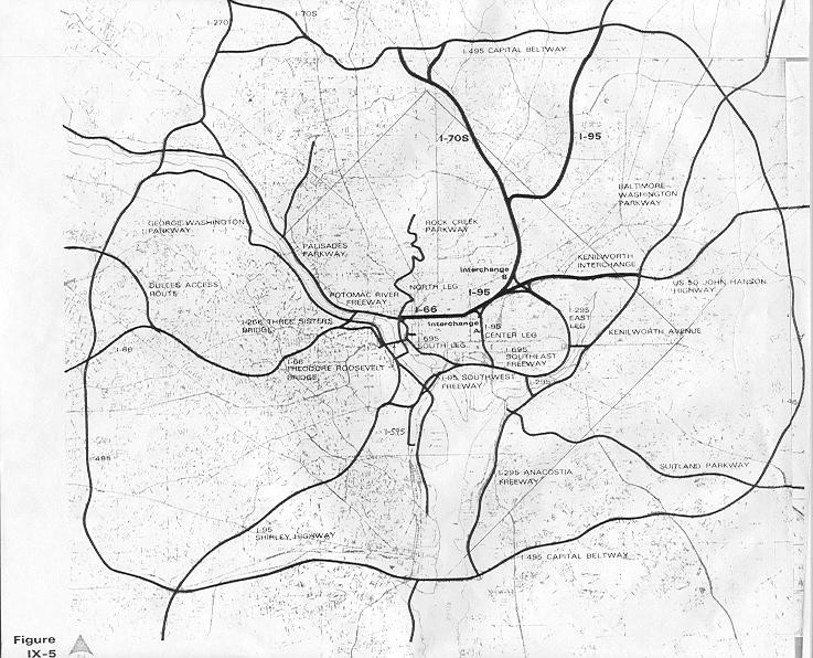
I've always wonder what DC would have looked like if they had built all the freeways that had been proposed in the '60s. I'm glad they didn't, but I do have fun driving on urban freeways like the BQE in New York, the Mass Pike in Boston, or the Southeast-Southwest Freeway here in DC. I gripe about how in DC (and Baltimore, for that matter) Freeways basically dead end in the city, dumping ridiculous volumes of automobile traffic in concentrated areas that ought to be more geared toward pedestrians. Either connect them, or get rid of them.

What is now I-395 was supposed to have connected along the Metropolitan Branch train line and connected to the stub at the I-95 interchange in College Park. Instead, it dead ends on New York Avenue, dumping thousands of cars onto what was intended to be a grand boulevard with vistas to the White House. Many of the funds from those abandoned highway projects were ultimately diverted to Metro. But the highway system proposed was far more in-depth than Metro today. Why didn't we match that ambition with trains?

Frankly, I don't care if the Shirley Highway is backed up. That highway is about six lanes wider than it ought to be anyway. I say, get rid of all those HOV lanes in the middle and add another Metro line, perhaps a light rail. Make it useful. Start it in Dale City, and have it run all along 95 and then 395 in the center lanes, all the way up toDC where it can connect underground to L'Enfant Plaza. Virginia commuters would then have the option to eschew the traffic on the freeway with a different kind of high occupancy vehicle: transit. Those giant empty spaces in the middle of highway exits? Throw parking garages in there. Giant park and rides taking tens of thousands of cars off the road every day.

I am curious to see what a study would say might happen if those HOV lanes were replaced with perhaps a light rail track with seamless connectivity to Metro stations (Franconia, Pentagon, and L'Enfant, perhaps).

Maybe this new line could even fight its way through the city and connect to I-95 in College Park, then head on up to Columbia. Sure it would be a long line, but it would do what ambitious freeway planners wanted I-95 to do: connect the region. Only this would be a far more responsible way of doing so.

Normally, I don't believe transit lines should run completely on freeways. I think freeways stifle the ability to place transit-oriented development around stations. I think a rail running along Rt. 1 in Maryland is far superior to one running along I-95, a parallel freeway a few miles west with no chance for promoting the same kind of good urbanism. But the Virginia portion of the above proposal would ostensibly replace a freeway, the one-way HOV lanes from Woodbridge to DC. Could trans move the same number of people during rush hour? They certainly would move people faster, considering they wouldn't have to suffer through Mixing Bowl traffic... they'd just speed right past it.

I wonder, has this proposal ever been thrown out there? Have such studies been conducted? Could a light rail move as many people as the HOV lanes, or would it have to be Metro, or something of even higher capacity?

Moving on from highways is going to take a plan as ambitious and extensive as the plan that put them here in the first place; a plan that can equal or best the largest public works project in human history. Why not start with superfluous lanes on a highway bringing thousands of people into the city every day?

Tuesday, September 30, 2008

BRAC =/= Community Building

Today I was talking to a good friend of mine at work about Takoma Park. She is a relative newcomer to the area, moving up here from the South just over a year ago. She works with me at Fort Meade, lives in Annapolis, and goes to church in Takoma Park. She was considering moving closer in to the city, but wasn't too fond of Takoma Park, her only experience with it being the two mile drive down University Boulevard from the Beltway to her church on Carroll Avenue.

This, of course, is right by where I grew up. So naturally, I had to chime in and offer to take her on a tour of a town much more pleasant than the snippets that she has experienced over the last sixteen months.

I could sing Takoma Park's praises for hours. It's a very pleasant streetcar suburb. It's very friendly, clean, and safe. It houses a very diverse spectrum of people. And it's close to everything. Frankly, I was perturbed that this hadn't been exposed to her previously. Why was this? I can attest that she is highly intelligent. But when she moved up here for her job at Fort Meade, my guess is that the hiring office pointed her toward the drab car-oriented apartment complexes of Central Maryland so that she could be (relatively) close to work. To her credit, she moved to Annapolis and not Columbia or Odenton, but nonetheless, after a year of suburban isolation, she wants to move closer to one of the cities.

She chose the DC area because that is where her church is, in Takoma Park. But a word she threw around often during our conversation was "community". Not just church community, but community as a place to live. Her apartment complex, though safe and quiet, offers no such sense of community.

I explained to her my philosophy on choosing an apartment complex (I've only once ever lived in one, and would never do it again now that I own a house, but I love offering my unwarranted advice). If you can enter an apartment building from a sidewalk along a street and you don't have to walk across a surface parking lot, it is more likely to be better than other apartment buildings in the area.
-Apartments with street entrances generally make better use of the land on which they lie, leaving fewer dark corners for crime to breed.
-They encourage pedestrian activity, which adds eyes on the street, detering criminal activity.
-People walking around are more likely to interact every day, and thus less likely to behave poorly towards each other (as I've found the anonymous neighbor might tend to do).
-Pedestrian activity also implies less dependence (real or perceived) on the automobile.
-Less automobile dependence ipso facto means less money spent on the automobile, which in turn implies a larger disposable income, raising their socio-economic status
-People of higher socio-economic status demand a higher standard of amenities and are less likely to tolerate crime or unsanitary conditions in and around the building.

Again, the above is just my own little method of choosing a decent apartment, and it is entirely unscientific. But I use the example of down town Silver Spring: The apartment buildings on East-West Highway between Georgia Avenue and Colesville Road are far superior than those just a quarter mile away in the Summit Hills complex (Slummit Thrills, as my college buddies who lived there call it) at East-West and 16th Street. Better urbanism makes a more palatable place to live. Thing is, we're seeing that transformation to urbanism in Silver Spring and Takoma Park... not so much in Anne Arundel and Howard Counties.

It got me to think about where I live. I work at Fort Meade, which I've stated before is absolutely horrible for the region as a whole. I live in Laurel, because it is close to work. My father, who also worked at Fort Meade, chose a much longer commute, coming from Silver Spring... because it was near my parents' church, good schools, a community. And he moved there in the car-happy early '70s. And now, I find myself driving to Silver Spring at least four times a week to partake in that community (my church, the football team I coach, my family, many of my friends). And drive I must, because Laurel doesn't have convenient transit for me to bus or train it to Silver Spring.

So now you have me driving 13 miles round trip to and from work every day, plus 25+ miles round trip to Silver Spring several times a week. Then there's my friend who drive about 41 miles round trip every day for work, plus another 62 miles round trip every Sunday for church. If we could commute to work via transit, chances are we'd both live near a transit hub, set our roots there, and that would eliminate 300+ miles driving a week right there. Richard Layman points out the dangers of sending thousands more jobs to military. If there are going to be thousands of new jobs sent out here with the BRAC, perhaps there should be an initiative to encourage these folks settle in an area-- a community-- that minimizes their impact on the highways (and their wallets) with the commute.

After the BRAC takes full effect, Fort Meade will have over 50,000 jobs on it, and thousands more around it. And Fort Meade doesn't have a single transit station. It's a ticking time bomb.

Thursday, July 10, 2008

Traffic Gutters to TOD

I've been thinking about the Arlington model for TOD. Where else could we do that around DC? Should we do it? I say yes, but I think the capital investment required will keep such fantasies in my optimistic imagination.

As I have stated before, I believe the combination of transit access and a useful street grid is what makes Arlington's Orange Line stretch what it is today. I think, with a little elbow grease, there are a few other corridors we could likely transform to stave off urban sprawl and bring the development back into the city.

Obviously we'd need transit. It looks like better transit may be coming in the form of busses soon. Still, TOD works better where there is fixed rail. I think improved fixed rail access can benefit the region if we place it along the right corridors. Here are my top ten:

1. Route 1 from College Park to Laurel
Beyond DC stated to me (above link, in the comments) that Metro expansion would be far more expensive than upgrading MARC to Metro-like service capability. This is true, but I don't see evidence where MARC has promoted TOD. If someone believes otherwise I'd love to get a little more informed on this. Anyway, with a string-of-pearls of small cities flanked by two freeways, this corridor is halfway there with the TOD. Considering the Base Relocation And Closure (BRAC) bringing thousands of jobs to Fort Meade, Beltsville and Laurel will only become more attractive places to live. I hope we can do it right and provide connectivity between the jobs and the houses, and throw in a few walkable commercial districts while we're at it. In the mean time, at least Route 1 has an initiative. (warning: pdf)

2. Columbia Pike in Arlington.
This road is a gateway to the heart of the District. It's an attractive place to live and a reasonable place from which one could commute into the city. Fortunately, there is a streetcar on the books for this corridor. I hope once if/when it is built, it will carry passengers all the way to L'Enfant, to jobs and four lines of the Metro.

3. Columbia Pike from Silver Spring to Columbia
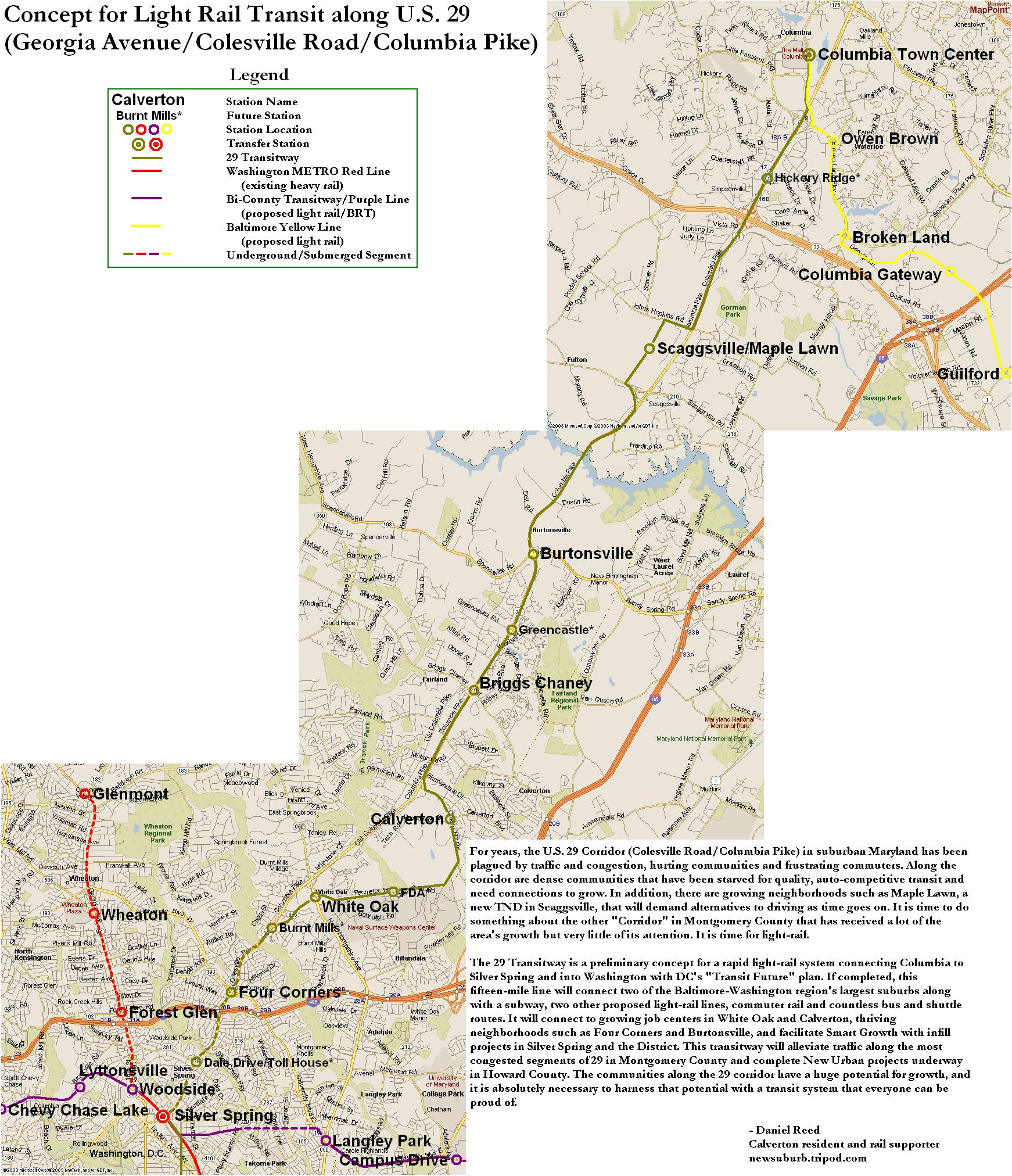
Also known as US29. This stretch is in the process of being turned into a limited access freeway from New Hampshire Avenue on up. But the highway design allows for light rail to be placed in the median. This could benefit some of the higher density developments in Briggs Chaney that are far from jobs. Light rail would be tricky, however, unless it went underground south of White Oak to Silver Spring, as 29 turns into another suburban traffic gutter south of there. A while back, Just Up The Pike produced this route, which would likely do the trick.

4. MD 355 from White Flint Mall to Germantown
Rockville Pike, Hungerford Drive, or Frederick Avenue... whatever you call MD355, it is a traffic gutter. I don't see why this has to be, considering that there is a freeway (I-270) running parallel a mile or so west. Many of the train stations are there thanks to the Red Line and the proposed Corridor Cities Transitway, but the corridor lacks a street grid supporting it. This vital technology corridor has been developed as urban sprawl so much that it now is seen as a major threat to Montgomery County farmland. Bringing that development inward can help reduce the negative effect on the farms and improve the corridor's positive impact on the regional economy.

5. Kenilworth Avenue from Cheverly to Konterra
Currently, Kenilworth Avenue ends in Beltsville, but construction should begin soon to extend the road to the Konterra site. The southern section passes though the abject blight of Prince George's County. Bladensburg, once a thriving seaport, has fallen into unsightly disrepair uncharacteristic of the charming town that 50 years ago was Chevy Chase with a waterfront. Edmonston, Riverdale, Berwyn Heights, and Greenbelt are also served by this road, which at parts looks more like a freeway. There is an effort to revitalized this stretch, though. The northern portion of this corridor could easily compliment the Route 1 corridor mentioned above. It would require more than the two existing Green Line Metro stations currently existing between the two corridors, but it is very doable and could create a far more suitable gateway between DC and Baltimore.

6. Alabama Avenue in Southeast
I wonder if a light rail along this road would promote some connectivity on the other side of the river. It certainly wouldn't have the economic impact that the other corridors boast, or even the potential for other corridors in Anacostia, but I believe it might improve the quality of life for Anacostia residents and make it a more attractive place to live or run a business. I'm sure this will never be a high priority, but it ought to get some attention as the central corridor of Southeast.

7. Georgia Avenue from Silver Spring to Olney
This is one of the first roads I picture when I think of a traffic gutter. It passes through so many great neighborhoods, commercial areas, and built up areas. It has four Red Line Stations. But the road has no charm or character. It's only there to shuttle people up and down the county. Residents would agree that there's absolutely no reason for this in Silver Spring, which is widely used by pedestrians that don't benefit from a six lane traffic gutter (or two! see #3) bisecting the town. Same at Seminary Lane. Same in Wheaton. And Glenmont. And Aspen Hill. And Rossmoor. And Olney. There's no reason Georgia Avenue can't be a real "avenue", or Main Street MoCo.

8. VA236/US50 from Alexandria to South Riding
This is a very long stretch, but again we have a road that's long and straight, passes through several town centers, and does little more for those towns than serve as a traffic gutter. There is currently no fixed guideway transit on this corridor except the King Street Metro station. That's nothing in Lincolnia, Bailey's Crossroads, Fairfax, Fair Oaks, Centerville, or South Riding. Wouldn't some transit on this stretch make it a more viable stretch to live or operate a business? Live here, walk around to do your errands, and commute to Alexandria.

9. University Boulevard from Kensington to College Park/Viers Mill Rd from Wheaton to Rockville
Yes, I'm calling out both of these entire roads. Kensington has no transit save for a MARC station, which is a shame because it's a wonderfully charming town where the walkability is swallowed up in 8 lanes of traffic. It is six lanes through Wheaton, Kemp Mill, and Four Corners. Langley Park is downright strangled by all the traffic lanes, making this "boulevard" a traffic gutter that is too clogged to effectively bring folks to its eponymous University of Maryland. As for Viers Mill Road, it connects this corridor to Rockville. driving it is painful even if it is the peth of least resistance to Rockville. It's time to admit that Viers Mill is no longer suburban, it is indeed very much urban. More transit, more TOD on these roads please!

10. New York and Rhode Island Avenues in Northeast
Could we use that MARC/CSX right of way for some local transit? I envision a line running from Union Station to Hyattsville along there. I support the District's attempts to make New York Avenue more like a city street, and what would help more than some TOD along the route? This could benefit Trinidad, Brentwood, Fort Lincoln, Ivy City, and in PG Mount Rainier, Cottage City Hyattsville, and Riverdale. These areas are so close to everything, and yet they're somewhat blighted. It would be of great benefit to the region to improve these areas.

Anyone else have some ideas about what corridors might be able to emulate the Orange Line part of Arlington?