The Transport Politic often showcases unique and clever transit solutions visualized by the site's author, Yonah Freemark. Recently he looked into the WMATA system and made an interesting proposal: a separated Blue Line, and running along it, another investment, a so-called Pink Line. Though Freemark's plan would add invaluable capacity and connectivity to our system, I believe a similar vision could be achieved without building another costly Potomac Crossing. That's not to say we shouldn't, but perhaps a closer term solution might look more like this:
View Pink Line in a larger map
The existing Potomac crossing where the Yellow Line connects Downtown and Pentagon City is underutilized and ought to have it's capacity increased before another crossing is built. This alternative combines the cross-Arlington connectivity that Freemark envisions without the circuitous route back through Rosslyn. This investment could be increased even more if the Green and Yellow Lines could be separated downtown, which might prove cheaper than the Blue Line separation. Another advantage would be that this line could just be an extension of the Silver Line, which would eliminate the need for a new line color.
New track miles are most valuable in the core. Unfortunately, they're also generally the most expensive new track miles. But the benefits to the entire region are huge across the entire system, making it a worthwhile investment. And it's about time we started considering "the rest of Arlington" more a part of the core.
Showing posts with label maps. Show all posts
Showing posts with label maps. Show all posts
Saturday, November 21, 2009

Friday, September 4, 2009
Baltimore Yellow Line Boondoggle
GGW's breakfast links yesterday had a troubling article at the bottom. The Central Maryland Transit Alliance wants to prioritize extending Baltimore's Yellow Line light rail to Columbia over extending the Green Line subway to White Marsh. I can't even begin to express how dumb of an idea this is.
The Green Line extension will hit developed areas in a large city with a burgeoning centralized train system in place. This is smart. The Yellow Line extension will connect Columbia to downtown Baltimore on a very long, very circuitous route that by-passes Fort Meade, the largest employment center in the state of Maryland.
Baltimore City needs transit connections. It needs an expanded system. It needs a centralized system. A Yellow Line extension would bolster businesses in Columbia and Towson. These are decentralized locations. A Green Line extension would bolster more centralized business districts like the Belair Road and Harford Road corridors. These are centralized areas. Baltimore has been decentralizing for fifty years, and it's not working.
From Columbia, the Yellow Line would take 42 minutes to get to BWI Airport, and then another 27 to get to downtown Baltimore. An hour and nine minutes to get from Columbia to Baltimore. The northern section of the Yellow Line is actually a good idea, connecting several colleges along a main thoroughfare through the city proper. But the southern portion is as circuitous and useless as the current plan for the CCT in Gaithersburg.
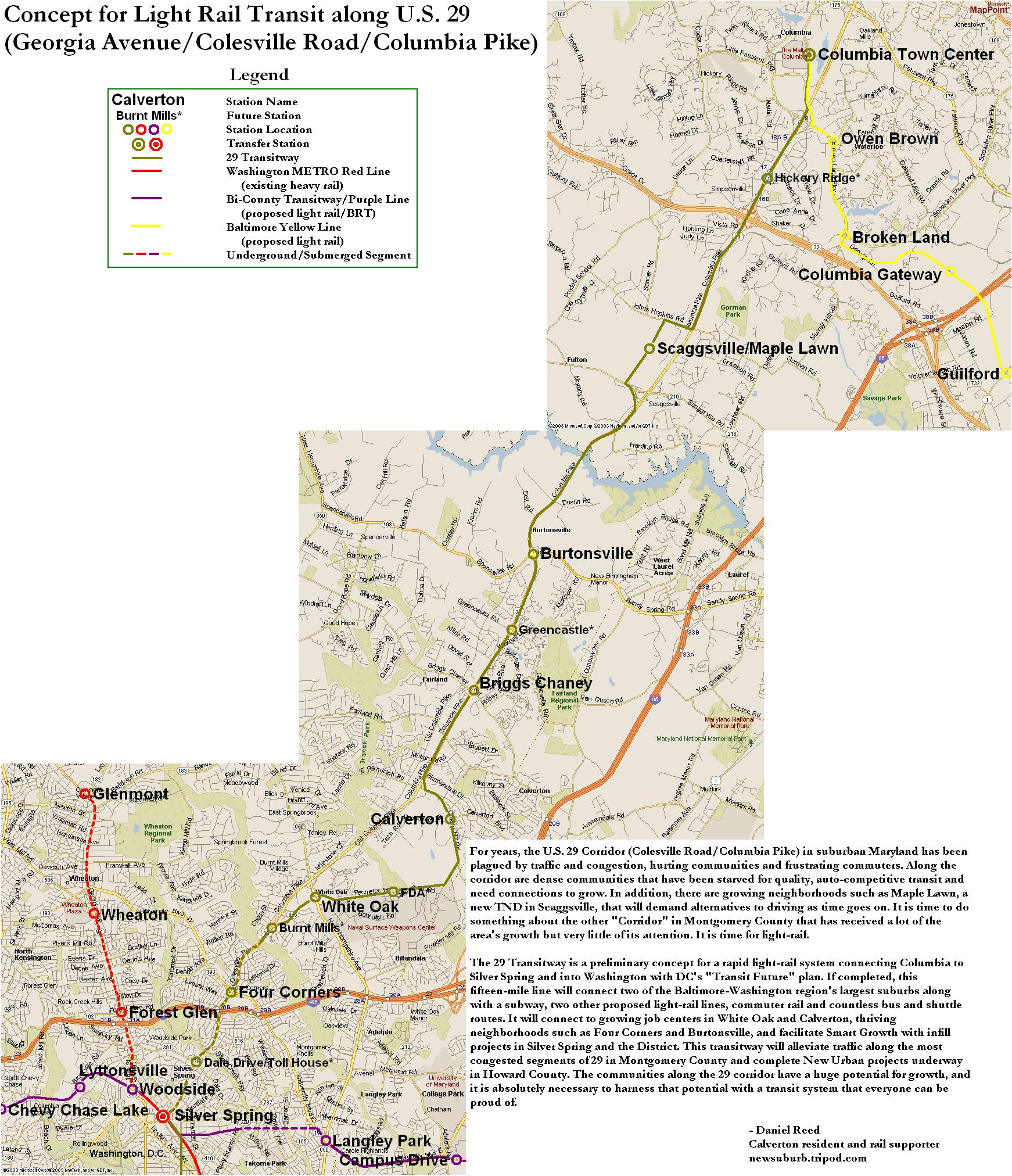
CMTA, if you want light rail connecting Columbia to the city, why not push for the US-29 light rail project that was once promised to run from Silver Spring to Columbia? A direct route to the city, not a circuitous one, that hits several established communities along the way is what Central Maryland Transit Alliance ought to be seeking. I don't know how long Dan Reed's alignment (linked above) would take to get from Columbia to downtown DC, but I bet it's faster than 69 minutes.
And if Maryland does decide to run light rail further away from Baltimore, can you at least make some effort to hit the 50,000+ job center at Fort Meade before it is completely choking the region with traffic? I bet you a rail right-of-way that a lot of those employees live in Columbia.
Thursday, June 25, 2009
Imagine A Seperate Green and Yellow Line
Naturally, there has been much written about the terrible Metro crash on the Red Line earlier this week. Had this been a nasty pile-up on the Beltway, we might have heard about it by by this point, we probably would have stopped talking about it by now, and it certainly never would have been international news. It is out of the ordinary, tragic, and was a failure of public infrastructure, unlike traffic accidents, which are usually the failures of individual drivers (we'll forgo the argument that fault may lie in road design). The fact that service disruptions continue on the Red Line is another reminder of this horrible accident. After all, these disruptions have a far greater impact on Metro than a bad traffic accident has on area highways.
If there is an accident on US-29 in Montgomery County, I can drive on Georgia or New Hampshire Avenues. But the stations that were shut down the past couple days isolated eastern Montgomery County from the rest of the Metro System. Originally, I tinkered with a map showing a separated Yellow Line for the sake of greater capacity and more geographic coverage for the Metro System. This week's accident has shown that adding redundancy to the system can be just as valuable as adding capacity.
Realizing the need for more redundancy on the system in the wake of this tragic crash is not an original idea. The Purple Line would obviously create alternate routes throughout the system. The Purple Line is both necessary and long overdue, however separating the Yellow and Green Lines would add capacity to existing track, much like separating the Blue and Orange Lines. In the case of the Yellow Line, it would allow for increased capacity on its Potomac River Bridge. If separated, the entire Green Line and the Yellow Line north of Pentagon would have the same capacity as the Red Line.
Here's what I would do with a separate Yellow Line:
View Separate Yellow Line in a larger map
This alignment is not 100% original either. Bringing Metro to North Capitol Street and Georgia Avenue is in no way a new idea. In these cases, however, people seem to want it for the geographic coverage, and not the additional capacity or system redundancy. Coverage is good, it brings transit to a new area. Capacity and redundancy, however, improve the entire system.
Perhaps I added a few too many stations, but they are just suggestions. While this would add service to the North Capitol Street and Georgia Avenue corridors, it would add redundancy to both the Green and Red Lines via Silver Spring, Georgia Av/Petworth, Union Station, and L'Enfant Plaza.
If this line existed already, the station closures on the Red Line might only have meant an additional transfer for Montgomery County commuters instead of the shuttle services to which Metro resorted after the crash.
Thursday, March 12, 2009
Saturday, January 24, 2009
New on Google Maps
I noticed on Friday that Google Maps has updated its imagery for Washington, DC. How did I notice? Well, this wasn't there before:
View Larger Map
Other cool areas you can check out changes:
-NoMa
-Columbia Heights
-Silver Spring
I was disappointed to see that National Harbor hasn't been updated. Post any other cool areas where you've seen a change. I love watching the city evolve over time. And we're lucky to be living in a city that's changing for the better.
Subscribe to:
Posts (Atom)

 Posts