Search This Blog

Monday, March 16, 2009

A Big Box Tale

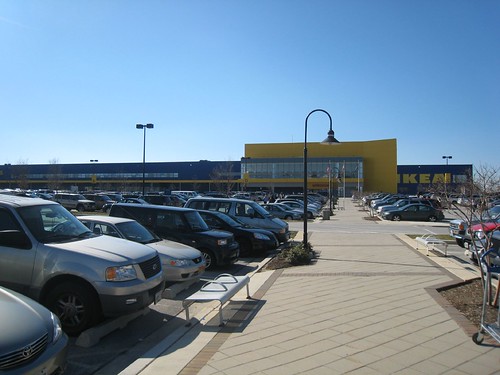
The massive parking lot of the College Park Ikea. Photo from Flickr by technotheory

When I moved into Laurel in late 2003, it seemed as if the city's primary industry was furniture sales. I found the jewel of the bunch, Carolina Furniture. I purchased the bulk of the furniture for my hew house at Carolina Furniture, then located on the corner of Main Street and Rt. 1. It was a small business, but had a very helpful staff and one of the best selections I have ever come across, especially impressive considering the modest size of the store. I loved it. I bought a couch and a love seat for half the price of what the Laurel Marlo (prominently located at Rt. 1 and Contee Road) was offering me for just the couch!

Then came the College Park Ikea. I'll admit, as far as big box stores go, I don't mind Ikea too much. But the College Park location was devastating to local businesses.

Carolina Furniture was the first to go. First it moved to an obviously cheaper site in an industrial park off Bowie Road. By early 2006, it had closed up shop. Galaxy Furniture, located on the site where Burtonsville's Dutch Country Farmers' Market was scheduled to move, fell shortly after. Another mile down Rt. 198 was Regency, a huge warehouse-like store located in a strip mall next to a Target. It closed up shop shortly after. Empire Furniture in Laurel Mall went next, followed by another smaller store that briefly opened in the mall. The tiny family-owned shop across from Galaxy closed just a few months ago. Several others have closed throughout the years in the industrial parks between Rt. 1 and the train tracks. Even the Peir One has closed its doors

Currently, Bargain Furniture is going out of business. This store sold scratched or irregular new furniture at a huge discount, and they offered delivery service only on a few select items. I thought this place would never close. It was always crowded with people looking for a deal on another store's rejected items. But today it is liquidating its stock, as you'll clearly see if you drive through the intersection of 197 and 198.

All in all, at least 9 furniture places have closed in Laurel in the last three years. The only furniture place left in Laurel is mega-chain Marlo, the only store in Laurel I've never recommended because of the poor service I recieved there when purchasing my furniture. All of them were either independent or small chains. I'm sure our recession has played a large part in shutting down these stores, but I can't help but think there were almost a dozen furniture stores before Ikea and now Laurel is down to one or two.

Ikea's iconic 200 foot sign visible from the Beltway for a mile in either direction draws people in to its acres and acres of parking. While the upper level features furniture, the lower level has all kinds of housewares, much like your average Wal-Mart (though of much better quality, generally). The store even features a Swedish cafeteria and a child day-care center. The furniture, however, is do-it-yourself. It is difficult at Ikea to find the country-style furniture I prefer. All the furniture is self-assembled. And no matter how friendly and courteous the staff at the store may be (they tend to be rather hard to pin down), you are one of thousands of shoppers. If you don't buy it, the next person will.

When I bought my living room and dining room sets at Carolina Furniture, everything was delivered and (if needed) assembled at my house at no extra charge. A year later, I took some Army buddies there who had just been stationed at Fort Meade. The sales rep recognized me immediately, even remembering my name and what I had bought. But in Laurel, it appears, those days are long gone. If I want to buy furniture locally, I have to stand in a long line at Ikea or get ripped off by Marlo.

Thursday, March 12, 2009

Light Posting Lately; The Metro Vision Update


Apologies for the light posting lately. I have been working a recession-induced second job, and much of my transit-nerd time has been devoted to poking around in Google Earth tweaking my Mass Transit Vision. I don't have much graphic design experience (read: I have none) and I'm slowly and painfully trying to learn how to use Inkscape, so it will be a while before I can post. it.

Shown right: a very early concept sketch.

Since I have gotten quite a few inquiries on this project, I thought I'd share some information. First of all, it won't be something we're likely to see in my grand-children's lifetime. It would probably cost a trillion or more to construct, and it would have far more capacity than this area could support with its current infrastructure and population. I haven't measured its current length, but I know it would be over 500 miles of track. I'll even go so far as to say it would be irresponsible to even study may of the proposed changes.

The concept I'm working has a core system with thirteen (!) lines, none of which share any track (i.e., separated the Green, Yellow, Blue, Orange and Silver lines from each other) so as to maximize capacity. There are six heavy rail and seven light rail/street car lines, a couple of the latter are spurred at the ends. I extended every single end of every existing and planned heavy rail line, though mostly only a station or two here and there. There are also several infill stations, particularly on the new separated routes. The light rails incorporate plans like the Anacostia Light Rail, the Columbia Pike transitways (both in VA and in MD), The Purple Line, and other DC streetcar proposals. There are two Purple Lines, in fact, both of which loop around the city (the Silver Spring-New Carrolton is the outer line). Much of it is completely unfeasible because it would require a fantastic amount of expensive tunnelling, right-of-way acquisition, engineering, and construction.

I expanded on MARC and VRE (but removed the Camden Line) and removed some of the smaller stations, treating them more like an integrated express service. Most of the smaller stops (like Riverdale and Clifton) were replaces with light rail stops. I put four Metro Lines at Union Station and likewise concentrated rail traffic to other MARC/VRE nodes like Silver Spring, L'Enfant Plaza, Rockville, New Carrollton, and King Street to emphasize their role as express lines.

Shown right: a later concept.

Also included in this plan are five supplemental services. In Maryland, the Corridor Cities Transitway, a series of light rail or BRT lines through Montgomery County (which I called Ride-On) and a light rail loop through Southern Maryland. In Virginia, I threw in a series of light rail/BRT lines for Fairfax and Prince William Counties, as well as an Aerotram along the "Techway" corridor from Shady Grove in Rockville to Dulles International Airport.

I have always felt like others' transit visions lack service in Prince Georges County and River East, so there is a concentration in those areas. I placed transit stops in close-in traditionally planned communities like Hyattsville's Arts District, Takoma Park, Old Town, and other places.

Denser areas that are poorly planned (Seven Corners, Tysons, Eastern MoCo, etc.) received lots of transit assuming they would be redeveloped into more transit oriented areas. Parts of the system are very far flung (Columbia, Fort Washington, South Riding, Woodbridge, Gaithersburg, Odenton, etc.)

I don't know if I'll include them initially, but I also have an integrated plan for Frederick, Annapolis, Baltimore, and the Atlantic Beaches.

Shown right: the current iteration of the project.

Basically, my goal was to visualize a Washington Metropolitan area that could support a population at least twice its current size, while allowing most of the city and closer-in region to comfortably live without a car. Hence its infeasibility. It has been a fun and interesting project so far, even if it has been overkill.

If anyone has the free time to teach me Inkscape, I would be much obliged, and would gladly provide a meal in exchange. Sadly I lack the graphic skills of the many other transit visions that have inspired me to embark on this project.

So please bear with me as I work my two jobs and attempt to get this into a nice readable map for everyone.

Map Nerdiness

Serious nerds only. Several of my friends have enjoyed this.

Sunday, March 8, 2009

Repurposing Urban Freeways

I have stated several times here that I believe urban freeways have their place in most cities, particularly in cities with lots of industrial and military activity. These are the purposes for which a federal highway system was created.

Unfortunately, these highways were not created for what they are most commonly used to accomplish: commuting. Most traffic congestion is caused by commuting. It occurs in the morning and evening rush hours. It costs trillions in wasted fuel, wasted time, and wasted environment.

What if commuting on highways was illegal?

This is a highly unlikely and rather radical approach to solve widescale congestion problems, and I have no reason to think it would take anywhere in the US right now. But what if urban freeways (like 295 and 395, for instance) were reserved only for transit, industrial (trucks), military, and emergency vehicles? Naturally this would have to come with an unrealistically large scale repurposing of our suburbs, which is why it is obviously not feasible. This hypothetical line of thought could argue a couple of advantages in the case of Washington, DC.

This would mean commuters would need to find alternative means of getting to DC. This would undoubtedly result in thousands of cars being taken off the road. the lack of cars commuting into or through the city would result in less space needed for commuter parking, which could allow more parks, residences, and businesses to be constructed throughout the city. It would likely result in a massive drop in car owners. This would increase the disposable income of area residents who no longer have need to own a car. (I have stated before that for me, this would be about 20% of my take home income). That would result in a higher tax base for the city, making it easier to invest in an expanded mass transit system, perpetuating a cycle that would reverse the negative effects of sprawl.

Industrial and military vehicles would be less likely to use the surface streets. In fact, they could even be outlawed from using surface streets, apart from approaches to the highways. though it might inconvenience some industrial traffic, I imagine that having an uncongested freeway would be an overall benefit for them. I am vehemently opposed to having military traffic running down city streets. To me this is something that they do in Tehran and Pyongyang, not Washington, DC.

Naturally, the drop in gas usage, exhaust, and vehicle miles traveled will be good for our environment. One could even go so far as to suggest that there would be an overall increase in walking, which could lead to better health. But more directly, the decrease in CO2 emissions will have an obvious and immediate impact on air quality.

Freeways are valuable tools of industry in America. They literally shaped the landscape and united the country in a way the world had never seen before. But they have been rendered near useless in much of the country becasue we allow them to be used for purposes which they were not originally intended. Perhaps rethinking the modality of freeways on some level could benefit a the local, municipal, regional, and national landscapes.