As scenic and wonderful as Laurel has been the past seven years, it looks like I'll finally be making my way back into the District. My humble abode will be going on the market this month.
I have a lot of history in the region here. I was born in Foggy Bottom. I grew up inside the Beltway in Silver Spring. I went to grade school just outside the Beltway, and high school in Wheaton. I attended Montgomery College, and I even lived in Rockville for a year. I joined the Army at 21 (pre-9/11, but just barely, if you were wondering) and resettled here after my basic and advanced training. I joined the Army to see the world, but they stationed me back in Maryland.
I purchased a house in Laurel in 2003 when I was 23 years old. I was a Specialist (E-4) in the Army at the time, making about $1,800 a month plus a housing allowance. It took a lot of scraping to stay in this house, but a couple of war zone deployments helped me pay the mortgage as my taxes skyrocketed during an unprecedented housing boom. After I got out of the Army, I languished in unemployment for about six months, during which I picked up odd jobs and took extreme measures to afford the mortgage until I managed to crack into a government job with an entry level wage suitable for allowing me to live somewhat comfortably while keeping my house.
I've come a long way since then, and so has the housing market, not to mention the city of Laurel and the DC Metro area. I know I am very fortunate to have survived the housing boom-and-bust and still have made money on my house. It was part determination, part luck, and part having smart people around me.
But as it goes, my current job sends me all over the DC area quite regularly and Laurel is no longer a suitable staging point. I'm moving back into the city of my birth, to a yet-to-be-determined neighborhood. Having grown up in the shadow of the Capitol and lived just about my entire life here and being a person who loves cities, it is a powerful notion for me to be moving back into a city that has overcome so much strife. In my youth, the mass exodus from DC was taking place. By the time I was in the sixth grade, DC was the murder capital of the US. While I was in high school, my mother fought with me every time I wanted to go to RFK or the 9:30 Club, citing my safety. And even as recently as 2004, the Army forbade me from going into the parts of the city where I am currently looking to purchase my next home.
But in November 2008, Election Day, I saw a celebration at 14th and U, an intersection that for the past forty years had been overcoming scars left by race riots, neglect, and construction of the Metro. It was a historic day for many reasons as Obama became the first African-American president in a critical period for the nation, but for me it was different, something that had nothing to do with politics. All kinds of people celebrated in the streets of a fully rejuvenated neighborhood. Washington had returned to being a great American city. It made me want to go back. And now it looks like I can finally do that.
So I'll be posting about that experience, schedule permitting. And if anyone is looking for a spot halfway between DC and Baltimore, I know of a cute little bungalow off of Route 1.
Showing posts with label DC. Show all posts
Showing posts with label DC. Show all posts
Tuesday, May 4, 2010

Sunday, January 3, 2010
Imagine a streetcar on Alabama Avenue
When DDOT unveiled its Streetcar vision in October, I was little disappointed by the amount of service in River East. Indeed, the area's reputation has been mired in negativity for quite some time, which has lead to, for better or worse, a very different kind of land and economic development in Wards 7 and 8. This is evident in the distribution of services proposed by DDOT.
River East has experienced a great deal of suburban style development. Wickedly suburban. Affordable housing is often not accessible to the six Metro stations that serve this third of the city. Isolated affordable housing can often turn out to be frighteningly similar to ill-fated housing projects. Requiring people of lower income to rely on automobile transport greatly increases their cost of living, further exacerbating the poverty. But shiny new developments in River East, for all their efforts at civic improvement, are still focused around the automobile.
What really disappointed me about DDOT's plan is that all the streetcar lines appear to run THROUGH River East. Along the Anacostia River, perhaps, but they fail to connect many of the neighborhoods to the system, including several that are not very accessible to Metro. This plan would lead me to infer that Congress Heights and Fairlawn are and will be for the foreseeable future dependent on the rest of the city to be a viable place to live. The lines connect River East to the rest of the city, but they don't connect River East to River East. Not as much as it could, at least.
With DC's population rocketing past 600,000 and developers running out of "River West" real estate to develop, Benning, Deanwood, Anacostia, Washington Highlands, Hillcrest, Fort Dupont, and the rest of River East's many neighborhoods will becoming increasingly attractive for development. But the same type of dense, walkable, transit-oriented, traditional neighborhood design is not possible if River East goes as underserved by streetcar as it is by Metro (6 stations versus 31 in the rest of DC and not transfer stations). So I conceived a line that would make it feasible to live in Congress Heights and work in Capitol Heights without taking Metro all the way to L'Enfant Plaza first. I give you a proposal for a ninth streetcar line, the Alabama Avenue line:
View River East Streetcars in a larger map
Blue indicates lines laid out in the DDOT plan, purple indicates possible future streetcar extension laid out in the plan, and red is the Alabama Avenue line. Obviously, significant portions of the line also run along Southern Avenue and Nannie Helen Burroughs Avenue. It connects prominent neighborhoods to Metro stations and other streetcar lines. It puts more of the rail transit infrastructure within walking distance for District residents who will benefit most from its service and economic development. It is intended to interact with the neighborhoods as places where a significant portion of the District now lives and could potentially work in the future.
Where the city will ultimately have a streetcar network, River East will only have lines. The Alabama Avenue line would create a network that would compliment the existing Metro stations and the already-planned streetcar lines. It may not generate enormous ridership projections right now, but it would certainly draw more walkable urban development to Alabama Avenue and the other proposed corridors. We plan roads in anticipation of future development. Why can't we make that same investment with our streetcar network?
Cross-posted on Imagine, DC
River East has experienced a great deal of suburban style development. Wickedly suburban. Affordable housing is often not accessible to the six Metro stations that serve this third of the city. Isolated affordable housing can often turn out to be frighteningly similar to ill-fated housing projects. Requiring people of lower income to rely on automobile transport greatly increases their cost of living, further exacerbating the poverty. But shiny new developments in River East, for all their efforts at civic improvement, are still focused around the automobile.
What really disappointed me about DDOT's plan is that all the streetcar lines appear to run THROUGH River East. Along the Anacostia River, perhaps, but they fail to connect many of the neighborhoods to the system, including several that are not very accessible to Metro. This plan would lead me to infer that Congress Heights and Fairlawn are and will be for the foreseeable future dependent on the rest of the city to be a viable place to live. The lines connect River East to the rest of the city, but they don't connect River East to River East. Not as much as it could, at least.
With DC's population rocketing past 600,000 and developers running out of "River West" real estate to develop, Benning, Deanwood, Anacostia, Washington Highlands, Hillcrest, Fort Dupont, and the rest of River East's many neighborhoods will becoming increasingly attractive for development. But the same type of dense, walkable, transit-oriented, traditional neighborhood design is not possible if River East goes as underserved by streetcar as it is by Metro (6 stations versus 31 in the rest of DC and not transfer stations). So I conceived a line that would make it feasible to live in Congress Heights and work in Capitol Heights without taking Metro all the way to L'Enfant Plaza first. I give you a proposal for a ninth streetcar line, the Alabama Avenue line:
View River East Streetcars in a larger map
Blue indicates lines laid out in the DDOT plan, purple indicates possible future streetcar extension laid out in the plan, and red is the Alabama Avenue line. Obviously, significant portions of the line also run along Southern Avenue and Nannie Helen Burroughs Avenue. It connects prominent neighborhoods to Metro stations and other streetcar lines. It puts more of the rail transit infrastructure within walking distance for District residents who will benefit most from its service and economic development. It is intended to interact with the neighborhoods as places where a significant portion of the District now lives and could potentially work in the future.
Where the city will ultimately have a streetcar network, River East will only have lines. The Alabama Avenue line would create a network that would compliment the existing Metro stations and the already-planned streetcar lines. It may not generate enormous ridership projections right now, but it would certainly draw more walkable urban development to Alabama Avenue and the other proposed corridors. We plan roads in anticipation of future development. Why can't we make that same investment with our streetcar network?
Cross-posted on Imagine, DC
Monday, September 7, 2009
Labor Day Quick Links
August and September are very busy months for me, so it's difficult to keep up with writing original articles regularly. But please, take a look at some of the links to the right, they are all interesting blogs. Here is a sampling.
DCMUD - More, better housing near a Metro station in a rapidly improving part of the city: Deanwood
GreaterGreaterWashington - Track Twenty-Nine's Matt Johnson has written three spectacular series on freight and passenger rail in DC, station motifs on Metro, and the naming conventions for streets in the District of Columbia
And Now, Anacostia - How soon before Anacostia has streetcars?
Southeast Socialite - Never mincing words, she comments on a critique of Marion Barry, and concern about Eleanor Holmes Norton's lack of responsiveness to public queries.
Bloomingdale (For Now) - Clarifies the location of a section of 7th Street being renamed in honor of the father of go-go
Fairfax Suburbanista - Fairfax City is suburbanizing its Old Town with suburban townhouses. I wonder why they don't just try a traditional plot of townhouses?
WalkLaurel - It's a new website that explains forthcoming pedestrian and traffic improvements in the city of Laurel
Just Up The Pike - Photographs of the ICC construction through an area where several people lost their homes for the sake of the project.
Baltimore Inner Space - Discusses the "low hanging fruit" plan for the Red Line
The Overhead Wire - Discusses the George W. Bush Presidential Library and its ironic proximity to transit
Extraordinary Observations - Are Whole Foods' high prices worth a boycott? Rob argues NO.
DC Sports Bog - While admitting to being on the wrong side of history, Dan Steinberg attempts to douse some of the fire over the Redskins ticket scandal.
Hope you check a few of these articles out. Hope everyone enjoys Labor Day in the seat of the free world.
DCMUD - More, better housing near a Metro station in a rapidly improving part of the city: Deanwood
GreaterGreaterWashington - Track Twenty-Nine's Matt Johnson has written three spectacular series on freight and passenger rail in DC, station motifs on Metro, and the naming conventions for streets in the District of Columbia
And Now, Anacostia - How soon before Anacostia has streetcars?
Southeast Socialite - Never mincing words, she comments on a critique of Marion Barry, and concern about Eleanor Holmes Norton's lack of responsiveness to public queries.
Bloomingdale (For Now) - Clarifies the location of a section of 7th Street being renamed in honor of the father of go-go
Fairfax Suburbanista - Fairfax City is suburbanizing its Old Town with suburban townhouses. I wonder why they don't just try a traditional plot of townhouses?
WalkLaurel - It's a new website that explains forthcoming pedestrian and traffic improvements in the city of Laurel
Just Up The Pike - Photographs of the ICC construction through an area where several people lost their homes for the sake of the project.
Baltimore Inner Space - Discusses the "low hanging fruit" plan for the Red Line
The Overhead Wire - Discusses the George W. Bush Presidential Library and its ironic proximity to transit
Extraordinary Observations - Are Whole Foods' high prices worth a boycott? Rob argues NO.
DC Sports Bog - While admitting to being on the wrong side of history, Dan Steinberg attempts to douse some of the fire over the Redskins ticket scandal.
Hope you check a few of these articles out. Hope everyone enjoys Labor Day in the seat of the free world.
Friday, September 4, 2009
Baltimore Yellow Line Boondoggle
GGW's breakfast links yesterday had a troubling article at the bottom. The Central Maryland Transit Alliance wants to prioritize extending Baltimore's Yellow Line light rail to Columbia over extending the Green Line subway to White Marsh. I can't even begin to express how dumb of an idea this is.
The Green Line extension will hit developed areas in a large city with a burgeoning centralized train system in place. This is smart. The Yellow Line extension will connect Columbia to downtown Baltimore on a very long, very circuitous route that by-passes Fort Meade, the largest employment center in the state of Maryland.
Baltimore City needs transit connections. It needs an expanded system. It needs a centralized system. A Yellow Line extension would bolster businesses in Columbia and Towson. These are decentralized locations. A Green Line extension would bolster more centralized business districts like the Belair Road and Harford Road corridors. These are centralized areas. Baltimore has been decentralizing for fifty years, and it's not working.
From Columbia, the Yellow Line would take 42 minutes to get to BWI Airport, and then another 27 to get to downtown Baltimore. An hour and nine minutes to get from Columbia to Baltimore. The northern section of the Yellow Line is actually a good idea, connecting several colleges along a main thoroughfare through the city proper. But the southern portion is as circuitous and useless as the current plan for the CCT in Gaithersburg.
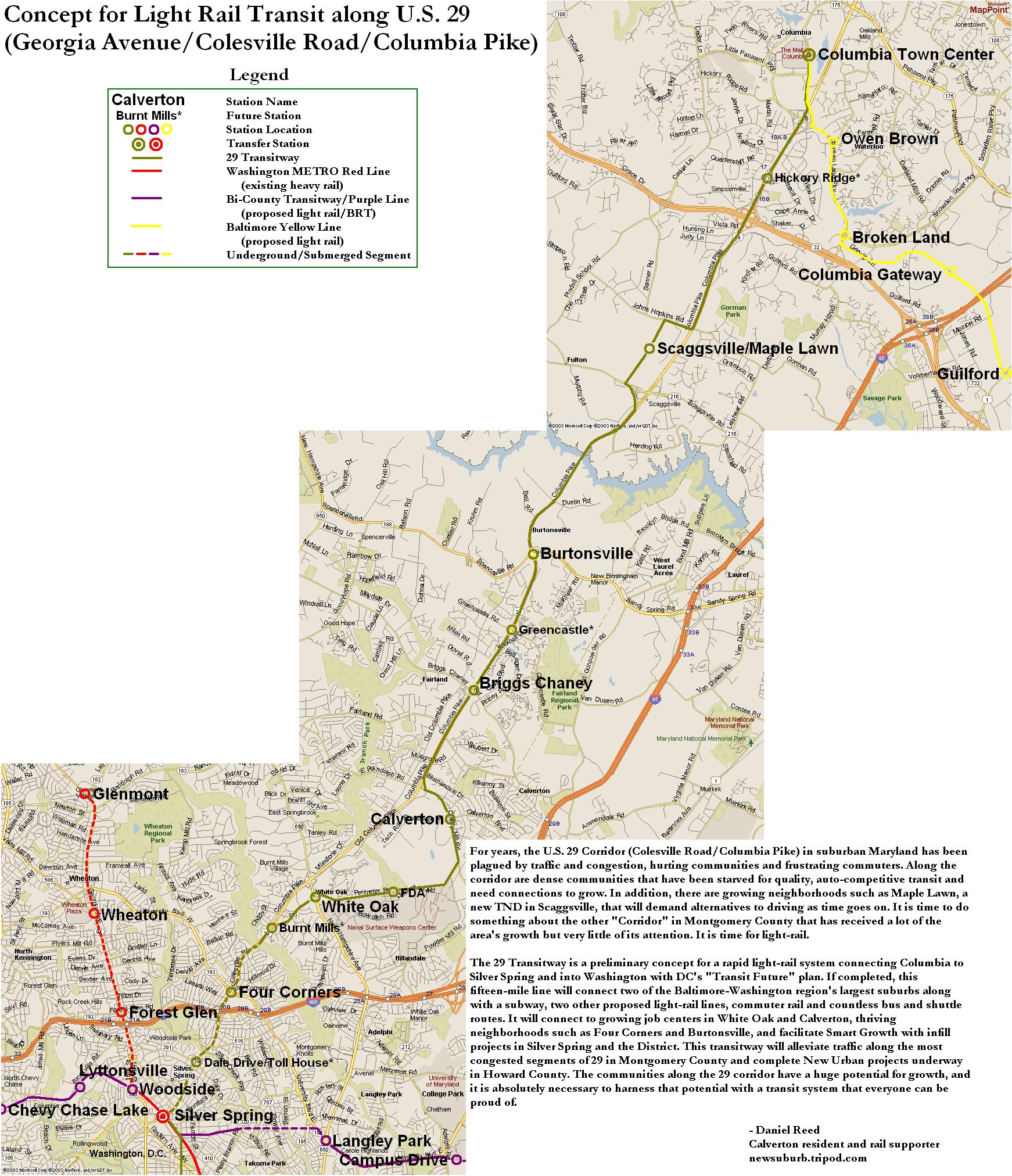
CMTA, if you want light rail connecting Columbia to the city, why not push for the US-29 light rail project that was once promised to run from Silver Spring to Columbia? A direct route to the city, not a circuitous one, that hits several established communities along the way is what Central Maryland Transit Alliance ought to be seeking. I don't know how long Dan Reed's alignment (linked above) would take to get from Columbia to downtown DC, but I bet it's faster than 69 minutes.
And if Maryland does decide to run light rail further away from Baltimore, can you at least make some effort to hit the 50,000+ job center at Fort Meade before it is completely choking the region with traffic? I bet you a rail right-of-way that a lot of those employees live in Columbia.
The Green Line extension will hit developed areas in a large city with a burgeoning centralized train system in place. This is smart. The Yellow Line extension will connect Columbia to downtown Baltimore on a very long, very circuitous route that by-passes Fort Meade, the largest employment center in the state of Maryland.
Baltimore City needs transit connections. It needs an expanded system. It needs a centralized system. A Yellow Line extension would bolster businesses in Columbia and Towson. These are decentralized locations. A Green Line extension would bolster more centralized business districts like the Belair Road and Harford Road corridors. These are centralized areas. Baltimore has been decentralizing for fifty years, and it's not working.
From Columbia, the Yellow Line would take 42 minutes to get to BWI Airport, and then another 27 to get to downtown Baltimore. An hour and nine minutes to get from Columbia to Baltimore. The northern section of the Yellow Line is actually a good idea, connecting several colleges along a main thoroughfare through the city proper. But the southern portion is as circuitous and useless as the current plan for the CCT in Gaithersburg.
CMTA, if you want light rail connecting Columbia to the city, why not push for the US-29 light rail project that was once promised to run from Silver Spring to Columbia? A direct route to the city, not a circuitous one, that hits several established communities along the way is what Central Maryland Transit Alliance ought to be seeking. I don't know how long Dan Reed's alignment (linked above) would take to get from Columbia to downtown DC, but I bet it's faster than 69 minutes.
And if Maryland does decide to run light rail further away from Baltimore, can you at least make some effort to hit the 50,000+ job center at Fort Meade before it is completely choking the region with traffic? I bet you a rail right-of-way that a lot of those employees live in Columbia.
Thursday, June 25, 2009
Imagine A Seperate Green and Yellow Line
Naturally, there has been much written about the terrible Metro crash on the Red Line earlier this week. Had this been a nasty pile-up on the Beltway, we might have heard about it by by this point, we probably would have stopped talking about it by now, and it certainly never would have been international news. It is out of the ordinary, tragic, and was a failure of public infrastructure, unlike traffic accidents, which are usually the failures of individual drivers (we'll forgo the argument that fault may lie in road design). The fact that service disruptions continue on the Red Line is another reminder of this horrible accident. After all, these disruptions have a far greater impact on Metro than a bad traffic accident has on area highways.
If there is an accident on US-29 in Montgomery County, I can drive on Georgia or New Hampshire Avenues. But the stations that were shut down the past couple days isolated eastern Montgomery County from the rest of the Metro System. Originally, I tinkered with a map showing a separated Yellow Line for the sake of greater capacity and more geographic coverage for the Metro System. This week's accident has shown that adding redundancy to the system can be just as valuable as adding capacity.
Realizing the need for more redundancy on the system in the wake of this tragic crash is not an original idea. The Purple Line would obviously create alternate routes throughout the system. The Purple Line is both necessary and long overdue, however separating the Yellow and Green Lines would add capacity to existing track, much like separating the Blue and Orange Lines. In the case of the Yellow Line, it would allow for increased capacity on its Potomac River Bridge. If separated, the entire Green Line and the Yellow Line north of Pentagon would have the same capacity as the Red Line.
Here's what I would do with a separate Yellow Line:
View Separate Yellow Line in a larger map
This alignment is not 100% original either. Bringing Metro to North Capitol Street and Georgia Avenue is in no way a new idea. In these cases, however, people seem to want it for the geographic coverage, and not the additional capacity or system redundancy. Coverage is good, it brings transit to a new area. Capacity and redundancy, however, improve the entire system.
Perhaps I added a few too many stations, but they are just suggestions. While this would add service to the North Capitol Street and Georgia Avenue corridors, it would add redundancy to both the Green and Red Lines via Silver Spring, Georgia Av/Petworth, Union Station, and L'Enfant Plaza.
If this line existed already, the station closures on the Red Line might only have meant an additional transfer for Montgomery County commuters instead of the shuttle services to which Metro resorted after the crash.
If there is an accident on US-29 in Montgomery County, I can drive on Georgia or New Hampshire Avenues. But the stations that were shut down the past couple days isolated eastern Montgomery County from the rest of the Metro System. Originally, I tinkered with a map showing a separated Yellow Line for the sake of greater capacity and more geographic coverage for the Metro System. This week's accident has shown that adding redundancy to the system can be just as valuable as adding capacity.
Realizing the need for more redundancy on the system in the wake of this tragic crash is not an original idea. The Purple Line would obviously create alternate routes throughout the system. The Purple Line is both necessary and long overdue, however separating the Yellow and Green Lines would add capacity to existing track, much like separating the Blue and Orange Lines. In the case of the Yellow Line, it would allow for increased capacity on its Potomac River Bridge. If separated, the entire Green Line and the Yellow Line north of Pentagon would have the same capacity as the Red Line.
Here's what I would do with a separate Yellow Line:
View Separate Yellow Line in a larger map
This alignment is not 100% original either. Bringing Metro to North Capitol Street and Georgia Avenue is in no way a new idea. In these cases, however, people seem to want it for the geographic coverage, and not the additional capacity or system redundancy. Coverage is good, it brings transit to a new area. Capacity and redundancy, however, improve the entire system.
Perhaps I added a few too many stations, but they are just suggestions. While this would add service to the North Capitol Street and Georgia Avenue corridors, it would add redundancy to both the Green and Red Lines via Silver Spring, Georgia Av/Petworth, Union Station, and L'Enfant Plaza.
If this line existed already, the station closures on the Red Line might only have meant an additional transfer for Montgomery County commuters instead of the shuttle services to which Metro resorted after the crash.
Saturday, February 21, 2009
Lady Bird Johnson Park
I have always thought Lady Bird Johnson Park was a little strange. Though closer to the Virginia shore, this island lies completely within the District, much like Roosevelt Island to the northwest. Although, unlike Roosevelt, this island is overrun with freeway spaghetti, most of it serving the Commonwealth and not the District. Also, this area is served by a Metro station, Arlington Cemetery. There is no residential, commercial, office, or industrial construction on the island, save a small marina on the south end. There are no park facilities. The entire area just seems like a serene setting to plop down a bunch of (confusing) highways.
Considering Lady Bird Johnson's efforts to beautify our nation's freeways, I suppose this is somewhat fitting (and probably intentional). though her Highway Beautification Act pertained mostly to interstates and ironically none of the highways on her island are interstates. Still, it seems like such a waste of a land. Why call it a "park" if there are no park facilities? It's not exactly the kind of place one can picnic or hike.
I would like to see the highway lanes consolidated, perhaps with some modest low rise apartments on the north side of the island oriented to the Metro station. And open the island up with some trails and waterside park facilities. Right now, the District seems to be allowing this land to be utilized only by the commuters in Arlington County.
Considering Lady Bird Johnson's efforts to beautify our nation's freeways, I suppose this is somewhat fitting (and probably intentional). though her Highway Beautification Act pertained mostly to interstates and ironically none of the highways on her island are interstates. Still, it seems like such a waste of a land. Why call it a "park" if there are no park facilities? It's not exactly the kind of place one can picnic or hike.
I would like to see the highway lanes consolidated, perhaps with some modest low rise apartments on the north side of the island oriented to the Metro station. And open the island up with some trails and waterside park facilities. Right now, the District seems to be allowing this land to be utilized only by the commuters in Arlington County.
Saturday, January 24, 2009
New on Google Maps
I noticed on Friday that Google Maps has updated its imagery for Washington, DC. How did I notice? Well, this wasn't there before:
View Larger Map
Other cool areas you can check out changes:
-NoMa
-Columbia Heights
-Silver Spring
I was disappointed to see that National Harbor hasn't been updated. Post any other cool areas where you've seen a change. I love watching the city evolve over time. And we're lucky to be living in a city that's changing for the better.
View Larger Map
Other cool areas you can check out changes:
-NoMa
-Columbia Heights
-Silver Spring
I was disappointed to see that National Harbor hasn't been updated. Post any other cool areas where you've seen a change. I love watching the city evolve over time. And we're lucky to be living in a city that's changing for the better.
Tuesday, January 13, 2009
How I'm Getting to the Inauguration
Hopefully I'll be over my cold by then, but I do plan on attending the Inauguration, which is now only a week away. But with massive transportation issues that day and estimates as high as 5 million people coming to town, getting there seems to be a scary proposition.
I'll have two out of town visitors that I'm putting up at my home in Laurel. My usual stations of choice are Greenbelt, College Park, Cheverly, and New Carrollton. But considering that the Green and Orange Lines are located on the Beltway, I think I'm going to try a different approach.
I'll be heading to Silver Spring Metro station. Here's why: first of all, the other stations on that end of the Red Line (Forest Glen, Wheaton, and Glenmont) will certainly see a great deal of volume, but I do not believe that the gobs of out-of-towners will be flooding them the way they will at Shady Grove, New Carrollton, and Greenbelt, considering the much more "ideal" locations of those stations being at major highway junctions. Forest Glen is right off the Beltway, but it is a tiny station, and it is not marked on the Beltway the way other stations are.
Second, Silver Spring has plenty of stuff to do. If for some reason I make it down there and there is good reason not to go into the city, there are dozens of places to go and watch history unfold on TV. I plan on catching dinner there after the festivities, and showing the area off to my cousin and his friend.
Third, ample parking. As a car-oriented person, I have to take this into account. Hopefully you won't have to do so. Silver Spring has ample garages, and there ought to be enough folks getting off work to make parking there a viable option. Also, I don't believe that tour buses will be flooding this station in the same manner that they will be flooding other outer stations.
My the first reason is my primary reason. I figure people coming from points south will flood the VA stations. From the northeast, they'll all head towards Greenbelt. From the northwest, Shady Grove, and from the east, New Carrollton. Perhaps Huntington and Branch Avenue might be decent options by that logic. Does anyone else have any good plan for getting down there? Are there major flaws in my logic? How are you getting down there?
I'll have two out of town visitors that I'm putting up at my home in Laurel. My usual stations of choice are Greenbelt, College Park, Cheverly, and New Carrollton. But considering that the Green and Orange Lines are located on the Beltway, I think I'm going to try a different approach.
I'll be heading to Silver Spring Metro station. Here's why: first of all, the other stations on that end of the Red Line (Forest Glen, Wheaton, and Glenmont) will certainly see a great deal of volume, but I do not believe that the gobs of out-of-towners will be flooding them the way they will at Shady Grove, New Carrollton, and Greenbelt, considering the much more "ideal" locations of those stations being at major highway junctions. Forest Glen is right off the Beltway, but it is a tiny station, and it is not marked on the Beltway the way other stations are.
Second, Silver Spring has plenty of stuff to do. If for some reason I make it down there and there is good reason not to go into the city, there are dozens of places to go and watch history unfold on TV. I plan on catching dinner there after the festivities, and showing the area off to my cousin and his friend.
Third, ample parking. As a car-oriented person, I have to take this into account. Hopefully you won't have to do so. Silver Spring has ample garages, and there ought to be enough folks getting off work to make parking there a viable option. Also, I don't believe that tour buses will be flooding this station in the same manner that they will be flooding other outer stations.
My the first reason is my primary reason. I figure people coming from points south will flood the VA stations. From the northeast, they'll all head towards Greenbelt. From the northwest, Shady Grove, and from the east, New Carrollton. Perhaps Huntington and Branch Avenue might be decent options by that logic. Does anyone else have any good plan for getting down there? Are there major flaws in my logic? How are you getting down there?
Saturday, December 27, 2008
Highways Schmighways
Last night, I was the designated driver, and me and my friends wound up out in down town Bethesda past Metro's closing time. So I drove my one buddy back to Rosslyn. At his request, I took Old Georgetown Road to the Beltway, then the GW Parkway to the US50 exit to get to his place.
On a whim, I decided to take the Key Bridge to M St and then Wisconsin Avenue back towards Bethesda to see how much longer it would have been. Now mind you, this was 3 a.m., but it took 8 minutes less to shoot up Wisconsin, and that's including a stop for gas.
Just thought it was interesting.
On a whim, I decided to take the Key Bridge to M St and then Wisconsin Avenue back towards Bethesda to see how much longer it would have been. Now mind you, this was 3 a.m., but it took 8 minutes less to shoot up Wisconsin, and that's including a stop for gas.
Just thought it was interesting.
Friday, December 26, 2008
Bus Parking for the Inauguration
The Washington Post put out a map of the charter bus parking plan for Inauguration Day. 10,000 buses are expected to flood the city with tourists, and it's a good idea to have a plan to deal with them. The map states that cars parked on the designated bus parking routes will be towed after midnight on the 20th. It also indicated that no buses will be parked on residential blocks.
The plan, however, is a little vague... according to the map, the neighborhoods between P, K, 12th and 21st Streets NW appear to be fair game. Same with NoMa, Near Southeast, and all of Southwest. Are these buses just going to park on the street? Did the area residents and businesses have any chance to chime in on this? Who exactly created this plan? (The Post's graphic is sourced to D.C. Homeland Security and Emergency Management Agency)
It appears that RFK's lots and perhaps the garage at Nationals Stadium will be used. This makes a lot of sense to me. But 10,000 is a lot of buses. I think if the city plans to park them on residential streets like the WaPo map suggests, the people who live and work in those neighborhoods ought to have a say.
The plan, however, is a little vague... according to the map, the neighborhoods between P, K, 12th and 21st Streets NW appear to be fair game. Same with NoMa, Near Southeast, and all of Southwest. Are these buses just going to park on the street? Did the area residents and businesses have any chance to chime in on this? Who exactly created this plan? (The Post's graphic is sourced to D.C. Homeland Security and Emergency Management Agency)
It appears that RFK's lots and perhaps the garage at Nationals Stadium will be used. This makes a lot of sense to me. But 10,000 is a lot of buses. I think if the city plans to park them on residential streets like the WaPo map suggests, the people who live and work in those neighborhoods ought to have a say.
Thursday, November 6, 2008
Rumination: 14th Street
I am not a political voice. I am a 29 year old Irish-Sicilian-American mid-level federal employee with just an associates degree. I have no political background other than growing up just outside the DC line. But I feel compelled to share my experiences on election day.
Politically, I liked both candidates. I am sorry John McCain will never get to be the president. I wish he had been 8 years ago, he would have been a much better president through 9/11. And as a war vet who served in Afghanistan and Iraq, I think he would have caught bin Laden and I don't think Iraq would have turned out how it did. But as he gave his very inspirational concession speech, it reinforced to me that now is not his time.
I then watched Barack Obama's victory speech, and for the first time in my adult life, I felt inspired watching a leader of this nation speak. I knew I would have an easy time getting behind whoever won the presidency (after working for W for 7 years, it wouldn't be that difficult to do) but President-Elect Obama's words left me with a sense of pride in serving the country.
But what really inspired me, really got me excited, was the people in the streets at 14th and U.
Growing up, we suburban kids threw around "14th Street" as a metonym for prostitution in DC. From the '68 riots until about 6 years ago, I was very wary about that part of town, which was blighted, crime ridden, and worn down. And for a "white boy" growing up in the suburbs, it represented a horrible racial stereotype, one that many were too ignorant to see past. The scars of the '68 riots were more than abandoned storefronts and crime, there was a psychological scar that was handed down to me and my generation, remnants of a different time where people saw something different and met it with fear and hate.
In 2002, I visited the African American Civil War Memorial for the first time, and I fell in love with the life that the Green Line brought to that part of the city. It was the DC I always wanted to see, the town my parents described to me, not the city that was abandoned and stereotyped from behind picket fences.
Last night, seeing this neighborhood once destroyed by race riots as an area where all types of people gathered to celebrate the election of the United States' first African-American Commander-in-Chief was a beautiful thing. It was a microcosm for the progress that makes this country so special, and it showcased the diversity and vibrancy that ought to be found in the capital of such a great country. I have always been proud to claim DC as the city of my birth, but never as proud as I was last night. It was a good night for DC.
Politically, I liked both candidates. I am sorry John McCain will never get to be the president. I wish he had been 8 years ago, he would have been a much better president through 9/11. And as a war vet who served in Afghanistan and Iraq, I think he would have caught bin Laden and I don't think Iraq would have turned out how it did. But as he gave his very inspirational concession speech, it reinforced to me that now is not his time.
I then watched Barack Obama's victory speech, and for the first time in my adult life, I felt inspired watching a leader of this nation speak. I knew I would have an easy time getting behind whoever won the presidency (after working for W for 7 years, it wouldn't be that difficult to do) but President-Elect Obama's words left me with a sense of pride in serving the country.
But what really inspired me, really got me excited, was the people in the streets at 14th and U.
Growing up, we suburban kids threw around "14th Street" as a metonym for prostitution in DC. From the '68 riots until about 6 years ago, I was very wary about that part of town, which was blighted, crime ridden, and worn down. And for a "white boy" growing up in the suburbs, it represented a horrible racial stereotype, one that many were too ignorant to see past. The scars of the '68 riots were more than abandoned storefronts and crime, there was a psychological scar that was handed down to me and my generation, remnants of a different time where people saw something different and met it with fear and hate.
In 2002, I visited the African American Civil War Memorial for the first time, and I fell in love with the life that the Green Line brought to that part of the city. It was the DC I always wanted to see, the town my parents described to me, not the city that was abandoned and stereotyped from behind picket fences.
Last night, seeing this neighborhood once destroyed by race riots as an area where all types of people gathered to celebrate the election of the United States' first African-American Commander-in-Chief was a beautiful thing. It was a microcosm for the progress that makes this country so special, and it showcased the diversity and vibrancy that ought to be found in the capital of such a great country. I have always been proud to claim DC as the city of my birth, but never as proud as I was last night. It was a good night for DC.
Tuesday, November 4, 2008
Election Updates (Before the Polls Open)
This is the third presidential election I will be enjoying my constitutionally granted right to vote, And I plan to make the most of it. I encourage everyone out there to do the same, on both the local and national levels. A couple of election day-related tidbits I wanted to put out there:
- I said gas would bottom out on election day. The Exxon at Rt. 1 and Cherry Lane is at $2.13, and it's $2.09 at the BP down the road if you get a car wash. It didn't drop below $2 around here as far as I can tell, but apparently it has in other parts of the country.
-Good news for Barack fans: In the Redskins last 17 pre-presidential election games, the incumbent party shares the same fate as the Redskins. In other words, if the Redskins win, the party in office wins. If the Redskins lose, the party in office loses. The Redskins lost to the Steelers on Monday Night Football, so your forecast is full of Hope with a chance of Change.
-If you live in DC, GreaterGreaterWashington has some helpful posts on local candidates which I find relatively objective and very informative.
-Virginia is a swing state this year, so get out and vote, Old Dominion!
-I don't generally spout off political views in this forum, but I encourage everyone to vote for candidates who will ultimately give more of a voice to the residents of the District of Columbia.
Hope everyone has a fulfilling day at the ballots. I'm hoping for a smooth democratic process and looking forward to an end to campaign ads.

- I said gas would bottom out on election day. The Exxon at Rt. 1 and Cherry Lane is at $2.13, and it's $2.09 at the BP down the road if you get a car wash. It didn't drop below $2 around here as far as I can tell, but apparently it has in other parts of the country.
-Good news for Barack fans: In the Redskins last 17 pre-presidential election games, the incumbent party shares the same fate as the Redskins. In other words, if the Redskins win, the party in office wins. If the Redskins lose, the party in office loses. The Redskins lost to the Steelers on Monday Night Football, so your forecast is full of Hope with a chance of Change.
-If you live in DC, GreaterGreaterWashington has some helpful posts on local candidates which I find relatively objective and very informative.
-Virginia is a swing state this year, so get out and vote, Old Dominion!
-I don't generally spout off political views in this forum, but I encourage everyone to vote for candidates who will ultimately give more of a voice to the residents of the District of Columbia.
Hope everyone has a fulfilling day at the ballots. I'm hoping for a smooth democratic process and looking forward to an end to campaign ads.
Friday, October 24, 2008
Crime Rides the Train
I have seen a million things like this since I started reading about mass transit expansion. Ryan Avent pointed me towards this article complaining about crime rising in a shopping center once a transit connection was made in East St. Louis. Mass transit will connect ruffians to places decent people like to shop. Reminds me of the Purple Line. I've established a modest readership of decent people, so I'll subdue my urge to curse like I did back in my Army days.
I'll admit, mass transit can get groups of people to visit areas they might not otherwise visit. Silver Spring is a good example, with its Red Line and ample bus line service, clientele from Northeast DC flocks to the area regularly. Are we to view this as a bad thing?
Fact of the matter is, kids from Northeast flock to down town Silver Spring because there is nothing to do in a good sized chunk of Northeast. Fortunately, Silver Spring is a very diverse area, and only a minority take issue with "bad city people" impacting their quality of life.
This xenophobic and often racist attitude is, in my opinion, largely counter productive. First of all, transit access does not increase crime. It may relocate some of it, but the fact of the matter is that right now, roads could just as easily connect criminals with whatever hangouts much easier than trains do.
Now, what do we do if crime moves into our lovely Christian suburb? You stand up to it, and make it known that it is not tolerated in Bethesda or Silver Spring or Falls Church. Then perhaps that mentality will follow the would-be thugs back to Hillcrest Heights or Deanwood, where perhaps they will be that much less tolerant of crime in their own neighborhood. Perhaps allowing people to take advantage of these wonderful amenities will inspire them to go back to Trinidad or Chillum and demand those amenities in their neighborhood, which might give the kids there something to do, and keep them off of crime. Who knows, maybe one day you'll leave your little upper-middle class bubble in Great Falls or Olney or Potomac and visit the shops at Langley Park or a new restaurant in Benning Ridge.
The change is going on right now in Anacostia, Hyattsville, and Capitol Heights.
But if we as a society are going to quarantine "undesirable" people to the "undesirable" parts of town, we are only guaranteeing that they will remain undesirable.
Besides, who gets to decide what is "undesirable"? Perhaps it is undesirable for lower income residents in parts of the region to be required to spend a good portion of their paycheck on an automobile to get to their job. Perhaps it is undesirable for University of Maryland students to trek a mile to the Metro station because the same type of xenophobia kept the train far from the campus.
I've lived in this area my entire life. Let me assure you that as recent as 20 years ago, there were parts of Georgetown that most well intentioned suburbanites wouldn't dream of visiting. While I was in high school in the mid 1990's, Columbia Heights was considered unsafe, and there were was practically nothing to do there. As recent as five years ago, the US Army banned soldiers at Fort Meade to go to Near Southeast unless they had some kind of official business there.
Without transit, U Street probably never would have recovered from the 1968 riots. NoMa would be just a bunch of empty parking lots. The Rosslyn-Ballston corridor would just be a bunch of derelict garages and warehouses. Rockville Pike would look more like Route 1 in Howard County.
So to Saint Louis, I say stand up to the crime there. Force that agenda on anyone wishing to visit the nicer parts of your town. force them to bring that back to East Saint Louis, and eventually it will be a place you might want to go visit. That's what we do here in DC.

I'll admit, mass transit can get groups of people to visit areas they might not otherwise visit. Silver Spring is a good example, with its Red Line and ample bus line service, clientele from Northeast DC flocks to the area regularly. Are we to view this as a bad thing?
Fact of the matter is, kids from Northeast flock to down town Silver Spring because there is nothing to do in a good sized chunk of Northeast. Fortunately, Silver Spring is a very diverse area, and only a minority take issue with "bad city people" impacting their quality of life.
This xenophobic and often racist attitude is, in my opinion, largely counter productive. First of all, transit access does not increase crime. It may relocate some of it, but the fact of the matter is that right now, roads could just as easily connect criminals with whatever hangouts much easier than trains do.
Now, what do we do if crime moves into our lovely Christian
The change is going on right now in Anacostia, Hyattsville, and Capitol Heights.
But if we as a society are going to quarantine "undesirable" people to the "undesirable" parts of town, we are only guaranteeing that they will remain undesirable.
Besides, who gets to decide what is "undesirable"? Perhaps it is undesirable for lower income residents in parts of the region to be required to spend a good portion of their paycheck on an automobile to get to their job. Perhaps it is undesirable for University of Maryland students to trek a mile to the Metro station because the same type of xenophobia kept the train far from the campus.
I've lived in this area my entire life. Let me assure you that as recent as 20 years ago, there were parts of Georgetown that most well intentioned suburbanites wouldn't dream of visiting. While I was in high school in the mid 1990's, Columbia Heights was considered unsafe, and there were was practically nothing to do there. As recent as five years ago, the US Army banned soldiers at Fort Meade to go to Near Southeast unless they had some kind of official business there.
Without transit, U Street probably never would have recovered from the 1968 riots. NoMa would be just a bunch of empty parking lots. The Rosslyn-Ballston corridor would just be a bunch of derelict garages and warehouses. Rockville Pike would look more like Route 1 in Howard County.
So to Saint Louis, I say stand up to the crime there. Force that agenda on anyone wishing to visit the nicer parts of your town. force them to bring that back to East Saint Louis, and eventually it will be a place you might want to go visit. That's what we do here in DC.
Friday, October 3, 2008
MARC =/= Metro
A lot of people criticize me for not liking MARC. I do like MARC, but I don't think it is a viable service to be integrated with Metro, and I think it only truly serves people who live and work along one of the corridors. Since it is not fully integrated with Metro, switching between the two services is an expensive inter-modal shift that deters people from using the system.
MARC's availability is another problem. Right now the system is wildly overcrowded. It only runs during the work week, during the day. The trains are overcrowded, and the availability to add more daily service is hampered by the fact that much of the system shares tracks with CSX and AMTRAK.
What really bothers me about the system is the fact that in the DC Metro area, MARC does not appear to influence transit-oriented development. Sure, some stations have good development, or at least plans for such development: Rockville, Silver Spring, Greenbelt, New Carrollton... of course, those stations all have Metro stations as well.
An excellent example of this would be the Kensington station. Kensington is on the Brunswick Line between Silver Spring and Rockville. Kensington is an incorporated town with a business district adjacent to the train station, but this station has done little to influence pedestrianism like in Rockville and Silver Spring, which have Metro stations. Kensington is merely a confluence of three rivers of cars, with a few office buildings and restaurants surrounded by parking.
View Larger Map of Kensington Lots of Parking fronting traffic gutters
I live on the Camden Line, perhaps the most useless fixed rail line in the region. I'm about halfway between the Laurel and Muirkirk stations. Muirkirk is a middle-of-nowhere station useful only to commuters who drive there from Beltsville. It serves no one. The Konterra development will be just across Rt 1, but it has seemingly little connectivity to the MARC station. It has been implied that Konterra's town center location along I-95 would support a new Metro station along I-95. Laurel is in the blossoming downtown of Laurel, a city of 30,000 people, but the station has little impact on development plans in the city. It seems that more of the development (such as Laurel Commons) has been more in anticipation for a future Metro station a mile or so south on an expanded Green Line.
View Larger Map of Muirkirk Station Office parks and no sidewalks
To make MARC a more viable system, it would require additional tracks along pretty much the entire system. Why not, then, build Metro tracks along the DC, PG, and MoCo portions of the system and connect those areas to the rest of the system with seamless transfers? Leave MARC as it is, a REGIONAL system that gets people between Baltimore, Washington, and Frederick. Heck, add another MARC line to Annapolis. We need MARC, but we can't treat it like a system that integrates areas into the greater transit system of the DC Metropolitan area.
MARC is not a suitable compliment to Metro. It may connect DC and Baltimore, but it doesn't connect Laurel, Bowie, Kensington, and other DC suburbs to the urban fabric of the metropolitan area.
My thoughts on replacing the stations on the lower portion of MARC with Metro:
Brunswick Line: Use the Yellow Line, build a spur at Ft. Totten and run along the Red Line to Silver Spring (Or better yet, run it under Georgia Avenue from Petworth Station to Silver Spring) and then along the Brunswick Line to Rockville.
Penn Line: Instead of terminating the Silver Line at Stadium-Armory, run the Silver Line along the Orange Line to New Carrollton and then extend it up to the BWI stop on the Penn Line. The Silver Line would then connect two major regional airports.
Camden Line: Bring the Green Line up to Laurel. Route One can support the TOD.
Of course this doesn't appear feasible, but as I have mentioned before, I believe our rail initiatives ought to be at least as ambitious as the Freeway Plan of the 1960's. Leave MARC. It is a great redundancy system for traveling between Baltimore and Washington. But instead of giving MARC more tracks, build tracks for a system that is going to effectively enhance the region's ability to develop more environmentally friendly transit-oriented suburbs with convenient transit access.

MARC's availability is another problem. Right now the system is wildly overcrowded. It only runs during the work week, during the day. The trains are overcrowded, and the availability to add more daily service is hampered by the fact that much of the system shares tracks with CSX and AMTRAK.
What really bothers me about the system is the fact that in the DC Metro area, MARC does not appear to influence transit-oriented development. Sure, some stations have good development, or at least plans for such development: Rockville, Silver Spring, Greenbelt, New Carrollton... of course, those stations all have Metro stations as well.
An excellent example of this would be the Kensington station. Kensington is on the Brunswick Line between Silver Spring and Rockville. Kensington is an incorporated town with a business district adjacent to the train station, but this station has done little to influence pedestrianism like in Rockville and Silver Spring, which have Metro stations. Kensington is merely a confluence of three rivers of cars, with a few office buildings and restaurants surrounded by parking.
View Larger Map of Kensington Lots of Parking fronting traffic gutters
I live on the Camden Line, perhaps the most useless fixed rail line in the region. I'm about halfway between the Laurel and Muirkirk stations. Muirkirk is a middle-of-nowhere station useful only to commuters who drive there from Beltsville. It serves no one. The Konterra development will be just across Rt 1, but it has seemingly little connectivity to the MARC station. It has been implied that Konterra's town center location along I-95 would support a new Metro station along I-95. Laurel is in the blossoming downtown of Laurel, a city of 30,000 people, but the station has little impact on development plans in the city. It seems that more of the development (such as Laurel Commons) has been more in anticipation for a future Metro station a mile or so south on an expanded Green Line.
View Larger Map of Muirkirk Station Office parks and no sidewalks
To make MARC a more viable system, it would require additional tracks along pretty much the entire system. Why not, then, build Metro tracks along the DC, PG, and MoCo portions of the system and connect those areas to the rest of the system with seamless transfers? Leave MARC as it is, a REGIONAL system that gets people between Baltimore, Washington, and Frederick. Heck, add another MARC line to Annapolis. We need MARC, but we can't treat it like a system that integrates areas into the greater transit system of the DC Metropolitan area.
MARC is not a suitable compliment to Metro. It may connect DC and Baltimore, but it doesn't connect Laurel, Bowie, Kensington, and other DC suburbs to the urban fabric of the metropolitan area.
My thoughts on replacing the stations on the lower portion of MARC with Metro:
Brunswick Line: Use the Yellow Line, build a spur at Ft. Totten and run along the Red Line to Silver Spring (Or better yet, run it under Georgia Avenue from Petworth Station to Silver Spring) and then along the Brunswick Line to Rockville.
Penn Line: Instead of terminating the Silver Line at Stadium-Armory, run the Silver Line along the Orange Line to New Carrollton and then extend it up to the BWI stop on the Penn Line. The Silver Line would then connect two major regional airports.
Camden Line: Bring the Green Line up to Laurel. Route One can support the TOD.
Of course this doesn't appear feasible, but as I have mentioned before, I believe our rail initiatives ought to be at least as ambitious as the Freeway Plan of the 1960's. Leave MARC. It is a great redundancy system for traveling between Baltimore and Washington. But instead of giving MARC more tracks, build tracks for a system that is going to effectively enhance the region's ability to develop more environmentally friendly transit-oriented suburbs with convenient transit access.
Wednesday, October 1, 2008
An I-95 Train?
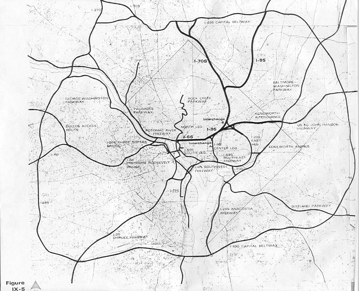
I've always wonder what DC would have looked like if they had built all the freeways that had been proposed in the '60s. I'm glad they didn't, but I do have fun driving on urban freeways like the BQE in New York, the Mass Pike in Boston, or the Southeast-Southwest Freeway here in DC. I gripe about how in DC (and Baltimore, for that matter) Freeways basically dead end in the city, dumping ridiculous volumes of automobile traffic in concentrated areas that ought to be more geared toward pedestrians. Either connect them, or get rid of them.
What is now I-395 was supposed to have connected along the Metropolitan Branch train line and connected to the stub at the I-95 interchange in College Park. Instead, it dead ends on New York Avenue, dumping thousands of cars onto what was intended to be a grand boulevard with vistas to the White House. Many of the funds from those abandoned highway projects were ultimately diverted to Metro. But the highway system proposed was far more in-depth than Metro today. Why didn't we match that ambition with trains?
Frankly, I don't care if the Shirley Highway is backed up. That highway is about six lanes wider than it ought to be anyway. I say, get rid of all those HOV lanes in the middle and add another Metro line, perhaps a light rail. Make it useful. Start it in Dale City, and have it run all along 95 and then 395 in the center lanes, all the way up toDC where it can connect underground to L'Enfant Plaza. Virginia commuters would then have the option to eschew the traffic on the freeway with a different kind of high occupancy vehicle: transit. Those giant empty spaces in the middle of highway exits? Throw parking garages in there. Giant park and rides taking tens of thousands of cars off the road every day.
I am curious to see what a study would say might happen if those HOV lanes were replaced with perhaps a light rail track with seamless connectivity to Metro stations (Franconia, Pentagon, and L'Enfant, perhaps).
Maybe this new line could even fight its way through the city and connect to I-95 in College Park, then head on up to Columbia. Sure it would be a long line, but it would do what ambitious freeway planners wanted I-95 to do: connect the region. Only this would be a far more responsible way of doing so.
Normally, I don't believe transit lines should run completely on freeways. I think freeways stifle the ability to place transit-oriented development around stations. I think a rail running along Rt. 1 in Maryland is far superior to one running along I-95, a parallel freeway a few miles west with no chance for promoting the same kind of good urbanism. But the Virginia portion of the above proposal would ostensibly replace a freeway, the one-way HOV lanes from Woodbridge to DC. Could trans move the same number of people during rush hour? They certainly would move people faster, considering they wouldn't have to suffer through Mixing Bowl traffic... they'd just speed right past it.
I wonder, has this proposal ever been thrown out there? Have such studies been conducted? Could a light rail move as many people as the HOV lanes, or would it have to be Metro, or something of even higher capacity?
Moving on from highways is going to take a plan as ambitious and extensive as the plan that put them here in the first place; a plan that can equal or best the largest public works project in human history. Why not start with superfluous lanes on a highway bringing thousands of people into the city every day?
What is now I-395 was supposed to have connected along the Metropolitan Branch train line and connected to the stub at the I-95 interchange in College Park. Instead, it dead ends on New York Avenue, dumping thousands of cars onto what was intended to be a grand boulevard with vistas to the White House. Many of the funds from those abandoned highway projects were ultimately diverted to Metro. But the highway system proposed was far more in-depth than Metro today. Why didn't we match that ambition with trains?
Frankly, I don't care if the Shirley Highway is backed up. That highway is about six lanes wider than it ought to be anyway. I say, get rid of all those HOV lanes in the middle and add another Metro line, perhaps a light rail. Make it useful. Start it in Dale City, and have it run all along 95 and then 395 in the center lanes, all the way up toDC where it can connect underground to L'Enfant Plaza. Virginia commuters would then have the option to eschew the traffic on the freeway with a different kind of high occupancy vehicle: transit. Those giant empty spaces in the middle of highway exits? Throw parking garages in there. Giant park and rides taking tens of thousands of cars off the road every day.
I am curious to see what a study would say might happen if those HOV lanes were replaced with perhaps a light rail track with seamless connectivity to Metro stations (Franconia, Pentagon, and L'Enfant, perhaps).
Maybe this new line could even fight its way through the city and connect to I-95 in College Park, then head on up to Columbia. Sure it would be a long line, but it would do what ambitious freeway planners wanted I-95 to do: connect the region. Only this would be a far more responsible way of doing so.
Normally, I don't believe transit lines should run completely on freeways. I think freeways stifle the ability to place transit-oriented development around stations. I think a rail running along Rt. 1 in Maryland is far superior to one running along I-95, a parallel freeway a few miles west with no chance for promoting the same kind of good urbanism. But the Virginia portion of the above proposal would ostensibly replace a freeway, the one-way HOV lanes from Woodbridge to DC. Could trans move the same number of people during rush hour? They certainly would move people faster, considering they wouldn't have to suffer through Mixing Bowl traffic... they'd just speed right past it.
I wonder, has this proposal ever been thrown out there? Have such studies been conducted? Could a light rail move as many people as the HOV lanes, or would it have to be Metro, or something of even higher capacity?
Moving on from highways is going to take a plan as ambitious and extensive as the plan that put them here in the first place; a plan that can equal or best the largest public works project in human history. Why not start with superfluous lanes on a highway bringing thousands of people into the city every day?
Tuesday, September 16, 2008
Top 10 Infill Sites Under the Radar
Poplar Point. The Soldiers Home. Near Southeast. Columbia Heights. The Kennedy Center. Anacostia. NoMa. Southwest Waterfront. It's no secret that DC is in the process of getting a makeover, and several prominent locations are seeing a major influx of infrastructure development that will bring new amenities to the city. the 50 year trend of exodus from DC is over.
There are a bunch areas that could probably use some urban infill, but I never hear about them. Perhaps this is because I'm not looking in the right places, perhaps it's because there are no plans, and perhaps it is because some of these places are wholly impractical for development. But I chose the 10 spots, all within the District, that I thought would be the best candidates for urban infill development that don't seem to be getting the attention they ought to deserve.
10. Buzzard Point
Southwest, between Potomac Avenue, South Capitol Street, and the Potomac River
With all the work being done around Nationals Park and Navy Yard, You don't hear too much about that nice little piece of riverfront real estate on the other side of South Capitol Street. On this map by the Capitol Riverfront BID, not much improvement is shown. This summer when I was down there exploring, it was still largely industrial wasteland north of V Street and parking lots and wasted riverfront vista south of V Street. That industrial stone plant at Half and R Streets HAS to go some times, doesn't it? I haven't heard anything about it yet.
9. Benning Power Plant
Northeast, Benning Rd between the Anacostia River and the Orange Line tracks
I talked about this last week. What is currently an antiquated and pollution creating coal power plant that blankets this neighborhood and adjacent estuary with heavy pollution could potentially be one of the top mixed-use locations on the Anacostia.
8. Fort Lincoln
Northeast, between New York, South Dakota, Bladensburg Rd, and the state line
Something looks like it is being built here, but I have no idea what. The wide roads are indicitive of future development, but I haven't been able to dig anything up on how whatever it is will fit into the urban fabric of Northeast or the surrounding historic communities in Prince George's County.
7. Lamond-Riggs
Northeast, Kansas Avenue at Blair Road
This area would be a great spot for an infill station on the Red Line. About halfway between the Fort Totten and Takoma stations, this area has seen its commercial areas blighted over the last few decades. A Metro station and a little investment could pay big dividends in this neighborhood.
6. RFK Stadium Site
Northeast and Southeast, along west bank of Anacostia River
Dan Snyder is jealous of the Dallas Cowboys planned stadium which, when completed, will be the largest stadium in the NFL. He also doesn't like the fact that FedEx field is outside the District. If he builds a new stadium at the RFK site (or anywhere else, for that matter), it will be a dome with a capacity approaching 110,000. This will attract a Super Bowl to the city. I'm all in favor of a venue of that size located in the district on a couple of Metro lines. But something needs to be done about that horrible surface parking. I love to tailgate, but I'll modify my gameday plans if it means less pavement along the river.
5. Saint Elizabeth's Hospital
Southeast, along MLK Avenue between Malcolm X Avenue and Suitland Parkway
I am aware of Department of Homeland Security's plans to relocate to some of the western portion of the campus, but currently most of the campus sits in disrepair while only the tiny portion on John Marr Circle is still used as a hospital. This area is full of historic buildings with spectacular vistas to the rivers, the Capitol, and other prominent DC landmarks. There's a ramp to an interstate and a Metro station. But over 30 years of disrepair has left this campus as a chunk of blight partitioning an area of the city in dire need of connectivity and economic development. And Now, Anacostia says the east campus looks like an Ivy League school. Well, why not put a university there? ANA hopes that a campus of UDC is located there when renovation begins. Current plans to break ground in 2012 will bring a mixed-use community.
4. Theodore Roosavelt Island
Northwest, in the Potomac River
I like to think that perhaps a Metro station could be built on the north end of the island, and a pedestrians-only colony might spring up on the island, which is currently only accessible via a footbridge from Rosslyn. A pipe dream. But who knows, when we run out of good real estate in the city, it may happen.
3. Fort Totten
Northeast, south of South Dakota Avenue and Riggs Road
This stop is served by three lines. It is the only such station in the system outside of downtown. But there's nothing there. This is completely unacceptable. I understand that there is not currently the road network to support very high density, nor would I call for such a network to be built. But can we manage some decent retail along South Dakota or Hamilton? Perhaps some better pedestrian access to the station? Perhaps it is just par for the curse for the Green Line, which is notoriously disconnected from its surrounding communities.
2. Ivy City
Northeast, between New York, Florida, and Mount Olivet Road
I would love to see a metro line built along New York Avenue out to Mount Rainier, Hyattsville, and ultimately College Park. But even without one, Ivy City sits along a favored corridor but remains mostly industrial and auto-oriented retail space. I would like to see New York Avenue become a grand boulevard leading downtown, and a makeover for Ivy city would be a nice start. I don't know of any plans to make this happen at this time.
1. McMillian Slow Sand Filter Plant
Northwest, between North Capitol and 1st Streets near the McMillian Reservoir
It took some research for me to figure out what was going on on this site. It seems like a prominent site for a park, a library, some condos, a marketplace, or just about anything over an abandoned water filtration plant. Alas, the filtration system below was built of unreinforced concrete, meaning significant and expensive retrofitting would have to be done of structures were to be built atop the site. To complicate matters, in 1991 it was deemed a historic landmark by the city. The fact that this eyesore sits deteriorating along North Capitol Street in a prominent part of the city is criminal. It sits between Howard and Catholic Universities, adjacent to the Hospital Center, with somewhat scenic views of the McMillian reservoir. isn't this important enough for someone to do something on this site, which has sat useless for over 20 yeas?
By all means, if you know of something I failed to mention on one of these sites, leave a comment. If you feel I left somewhere out, let me know.
50 years ago, race riots and highway construction gutted the Capitol City, but finally this trend is reversing, and Washington is a highly desirable city worthy of building up. Now is the time to invest in the blighted or underutilized spots in the city. We can't let areas like these be ignored.

There are a bunch areas that could probably use some urban infill, but I never hear about them. Perhaps this is because I'm not looking in the right places, perhaps it's because there are no plans, and perhaps it is because some of these places are wholly impractical for development. But I chose the 10 spots, all within the District, that I thought would be the best candidates for urban infill development that don't seem to be getting the attention they ought to deserve.
10. Buzzard Point
Southwest, between Potomac Avenue, South Capitol Street, and the Potomac River
With all the work being done around Nationals Park and Navy Yard, You don't hear too much about that nice little piece of riverfront real estate on the other side of South Capitol Street. On this map by the Capitol Riverfront BID, not much improvement is shown. This summer when I was down there exploring, it was still largely industrial wasteland north of V Street and parking lots and wasted riverfront vista south of V Street. That industrial stone plant at Half and R Streets HAS to go some times, doesn't it? I haven't heard anything about it yet.
9. Benning Power Plant
Northeast, Benning Rd between the Anacostia River and the Orange Line tracks
I talked about this last week. What is currently an antiquated and pollution creating coal power plant that blankets this neighborhood and adjacent estuary with heavy pollution could potentially be one of the top mixed-use locations on the Anacostia.
8. Fort Lincoln
Northeast, between New York, South Dakota, Bladensburg Rd, and the state line
Something looks like it is being built here, but I have no idea what. The wide roads are indicitive of future development, but I haven't been able to dig anything up on how whatever it is will fit into the urban fabric of Northeast or the surrounding historic communities in Prince George's County.
7. Lamond-Riggs
Northeast, Kansas Avenue at Blair Road
This area would be a great spot for an infill station on the Red Line. About halfway between the Fort Totten and Takoma stations, this area has seen its commercial areas blighted over the last few decades. A Metro station and a little investment could pay big dividends in this neighborhood.
6. RFK Stadium Site
Northeast and Southeast, along west bank of Anacostia River
Dan Snyder is jealous of the Dallas Cowboys planned stadium which, when completed, will be the largest stadium in the NFL. He also doesn't like the fact that FedEx field is outside the District. If he builds a new stadium at the RFK site (or anywhere else, for that matter), it will be a dome with a capacity approaching 110,000. This will attract a Super Bowl to the city. I'm all in favor of a venue of that size located in the district on a couple of Metro lines. But something needs to be done about that horrible surface parking. I love to tailgate, but I'll modify my gameday plans if it means less pavement along the river.
5. Saint Elizabeth's Hospital
Southeast, along MLK Avenue between Malcolm X Avenue and Suitland Parkway
I am aware of Department of Homeland Security's plans to relocate to some of the western portion of the campus, but currently most of the campus sits in disrepair while only the tiny portion on John Marr Circle is still used as a hospital. This area is full of historic buildings with spectacular vistas to the rivers, the Capitol, and other prominent DC landmarks. There's a ramp to an interstate and a Metro station. But over 30 years of disrepair has left this campus as a chunk of blight partitioning an area of the city in dire need of connectivity and economic development. And Now, Anacostia says the east campus looks like an Ivy League school. Well, why not put a university there? ANA hopes that a campus of UDC is located there when renovation begins. Current plans to break ground in 2012 will bring a mixed-use community.
4. Theodore Roosavelt Island
Northwest, in the Potomac River
I like to think that perhaps a Metro station could be built on the north end of the island, and a pedestrians-only colony might spring up on the island, which is currently only accessible via a footbridge from Rosslyn. A pipe dream. But who knows, when we run out of good real estate in the city, it may happen.
3. Fort Totten
Northeast, south of South Dakota Avenue and Riggs Road
This stop is served by three lines. It is the only such station in the system outside of downtown. But there's nothing there. This is completely unacceptable. I understand that there is not currently the road network to support very high density, nor would I call for such a network to be built. But can we manage some decent retail along South Dakota or Hamilton? Perhaps some better pedestrian access to the station? Perhaps it is just par for the curse for the Green Line, which is notoriously disconnected from its surrounding communities.
2. Ivy City
Northeast, between New York, Florida, and Mount Olivet Road
I would love to see a metro line built along New York Avenue out to Mount Rainier, Hyattsville, and ultimately College Park. But even without one, Ivy City sits along a favored corridor but remains mostly industrial and auto-oriented retail space. I would like to see New York Avenue become a grand boulevard leading downtown, and a makeover for Ivy city would be a nice start. I don't know of any plans to make this happen at this time.
1. McMillian Slow Sand Filter Plant
Northwest, between North Capitol and 1st Streets near the McMillian Reservoir
It took some research for me to figure out what was going on on this site. It seems like a prominent site for a park, a library, some condos, a marketplace, or just about anything over an abandoned water filtration plant. Alas, the filtration system below was built of unreinforced concrete, meaning significant and expensive retrofitting would have to be done of structures were to be built atop the site. To complicate matters, in 1991 it was deemed a historic landmark by the city. The fact that this eyesore sits deteriorating along North Capitol Street in a prominent part of the city is criminal. It sits between Howard and Catholic Universities, adjacent to the Hospital Center, with somewhat scenic views of the McMillian reservoir. isn't this important enough for someone to do something on this site, which has sat useless for over 20 yeas?
By all means, if you know of something I failed to mention on one of these sites, leave a comment. If you feel I left somewhere out, let me know.
50 years ago, race riots and highway construction gutted the Capitol City, but finally this trend is reversing, and Washington is a highly desirable city worthy of building up. Now is the time to invest in the blighted or underutilized spots in the city. We can't let areas like these be ignored.
Sunday, September 7, 2008
Imagine River Terrace
GreaterGreaterWashington thinks there should be a Metro station there. So does BeyondDC. Track Twenty-Nine envisions four Metro lines going right through that area. It's a little over two miles from the Capitol, on top of a freeway and an existing Metro station, scenically located next to the Anacostia River and the Arboretum, and a walk across the bridge to RFK Stadium. River Terrace a prime piece of real estate in the world's most powerful city. Why then, is it so blighted?
How about a coal power plant? And not one of the new, waste-recovery coal power plants. This one dates back to 1906. Though it only runs on the hottest and coldest of days when the city burns more energy, it blankets the surrounding communities with an average of 1,000 pounds of carbon smog a day, causing neighborhood residents to be 3 to 5 times more likely to have cancer, asthma or bronchitis than any other group of people in the city.
Maybe it's the housing projects. The Great Society-era Mayfair projects were home to Marvin Gaye, but I submit that their location and orientation do little to empower low income residents on the eastern bank of the Anacostia. At the very least, they do less than they could. Though close to Minnesota Avenue Metro Station, they are isolated from amenities and their surrounding communities. Affordable housing in this case is a sentence to a blighted campus of garden apartments disconnected from the rest of the city.
What if Goerge Gurley and the African American Environmental Association succeeded in having this plant shut down? What if the housing projects were redeveloped into a walkable neighborhood with ample connections to the surrounding neighborhoods? What if mixed-income and mixed-use came together on top of a new Metro station? Construct a marina and other local amenities, offer modest leases for local businesses, and tax breaks for minority and veteran business owners, and then you have my vision of a new River Terrace and Mayfair:
 Red - Residential
Blue - Commercial
Yellow - Civic
Green - Parkland
Orange - Transit
As always, the disclaimer
The orange on the left would be the River Terrace Metro Station, Blue and Orange Lines, perhaps a street car or two. A station with multiple lines on the east side of the Anacostia River, what a novel idea. To the north of it, a classical transit-oriented development with office over retail inside of residential units of gradually decreasing density.
Mayfair would (almost) completely torn down and redeveloped into an actual community rather than a dumping ground of cheap housing. I'm picturing townhouses and walk-up apartments, perhaps some street level retail. Yes, we should actually put jobs near cheap housing. Mayfair would be more oriented towards the Minnesota Avenue station, however good street connectivity would allow a variety of transit options.
The bit of commercial along the riverfront would include a marina and perhaps a fishing pier. This could be the primary attraction/amenity for the development. It would certainly be a lot more eco-friendly than a coal burning power plant.
Most importantly, if something like this is to happen to a neighborhood, it has to happen without displacing the current residents. Give the folks in Mayfair first crack at the moderatly priced River Terrace development, then redevelop Mayfair, keeping the area available to nearby residents of DC. Businesses should be heavily favored toward River Terrace, Mayfair, and Deanwood residents.
Now, what about the displaced power supply? Perhaps this could be supplemented by new nuclear plants in more remote Maryland and Virginia locations. Perhaps throw some windmills down at the Blue Plains Water Treatment Plant further down the river. But whether or not this part of town is developed, that power plant has to go. I'm all for coal power over other fossil fuels, but certainly not in the middle of the Capital City, and definitely not in a neighborhood where its presence purports a sense of inequality for the predominantly black neighborhoods east of the Anacostia.
Possible? Likely? Does anyone know of any plans to develop this power plant? Or to replace it? I'd love to see more info on it.
How about a coal power plant? And not one of the new, waste-recovery coal power plants. This one dates back to 1906. Though it only runs on the hottest and coldest of days when the city burns more energy, it blankets the surrounding communities with an average of 1,000 pounds of carbon smog a day, causing neighborhood residents to be 3 to 5 times more likely to have cancer, asthma or bronchitis than any other group of people in the city.
Maybe it's the housing projects. The Great Society-era Mayfair projects were home to Marvin Gaye, but I submit that their location and orientation do little to empower low income residents on the eastern bank of the Anacostia. At the very least, they do less than they could. Though close to Minnesota Avenue Metro Station, they are isolated from amenities and their surrounding communities. Affordable housing in this case is a sentence to a blighted campus of garden apartments disconnected from the rest of the city.
What if Goerge Gurley and the African American Environmental Association succeeded in having this plant shut down? What if the housing projects were redeveloped into a walkable neighborhood with ample connections to the surrounding neighborhoods? What if mixed-income and mixed-use came together on top of a new Metro station? Construct a marina and other local amenities, offer modest leases for local businesses, and tax breaks for minority and veteran business owners, and then you have my vision of a new River Terrace and Mayfair:
 Red - Residential
Blue - Commercial
Yellow - Civic
Green - Parkland
Orange - Transit
As always, the disclaimer
The orange on the left would be the River Terrace Metro Station, Blue and Orange Lines, perhaps a street car or two. A station with multiple lines on the east side of the Anacostia River, what a novel idea. To the north of it, a classical transit-oriented development with office over retail inside of residential units of gradually decreasing density.
Mayfair would (almost) completely torn down and redeveloped into an actual community rather than a dumping ground of cheap housing. I'm picturing townhouses and walk-up apartments, perhaps some street level retail. Yes, we should actually put jobs near cheap housing. Mayfair would be more oriented towards the Minnesota Avenue station, however good street connectivity would allow a variety of transit options.
The bit of commercial along the riverfront would include a marina and perhaps a fishing pier. This could be the primary attraction/amenity for the development. It would certainly be a lot more eco-friendly than a coal burning power plant.
Most importantly, if something like this is to happen to a neighborhood, it has to happen without displacing the current residents. Give the folks in Mayfair first crack at the moderatly priced River Terrace development, then redevelop Mayfair, keeping the area available to nearby residents of DC. Businesses should be heavily favored toward River Terrace, Mayfair, and Deanwood residents.
Now, what about the displaced power supply? Perhaps this could be supplemented by new nuclear plants in more remote Maryland and Virginia locations. Perhaps throw some windmills down at the Blue Plains Water Treatment Plant further down the river. But whether or not this part of town is developed, that power plant has to go. I'm all for coal power over other fossil fuels, but certainly not in the middle of the Capital City, and definitely not in a neighborhood where its presence purports a sense of inequality for the predominantly black neighborhoods east of the Anacostia.
Possible? Likely? Does anyone know of any plans to develop this power plant? Or to replace it? I'd love to see more info on it.
Friday, July 25, 2008
Top 10: Schools that Need Train Stations
Catholic University, Gallaudet University, and University of DC sit atop Red Line stations. Tiny Southeastern University is right outside Waterfront station on the Green Line. Bowie State has its own dedicated MARC station. What's great about this is that it connects these students to a city that can offer experiences and opportunities that add value to any type of education. It creates a higher standard of living for the students, and it makes the campuses more accessible to people who want to learn. It connects communities to the cultural exchanges that occur on college campuses: the concerts, the plays, the sports, the festivals. It better prepares students for the real world, and to some degree, it prepares the real world for them.
Unfortunately, it's a lot easier to go to college around here if you have a car, particularly if it is a school where you can't live in the dorms. We all know a forced bus-to-train transfer automatically decreases the likelihood of ridership, so I compiled my list of colleges and universities that most need train stations.
All figures are from Wikipedia unless otherwise noted.
10. Columbia Union College
This is basically just a commentary on how Takoma Park needs a trolley or something running through that town. Adventist Hospital, the shops at Carroll and Philadelphia Avenues, and the dense-ish areas of the town are a tad isolated from the rail infrastructure. Columbia Union College has only about 1100 students, but I believe the community could benefit from connecting this school to the outside world.
9. University of Maryland, College Park
Hopefully soon this will not be an issue. Flagship University of the State of Maryland, largest employer in Prince George's County, and educating over 36,000 students, This school is underserved by a Metro station miles away from the campus center. The forgotten factor: UMCP also houses University of Maryland University College, which has over 90,000 students. Most of these are online, but several classes are taught on the campus, and plenty of jobs are located at its headquarters near the proposed Purple Line West Campus station.
8. United States Naval Academy
Considering its proximity to the Nation's Capital, the Naval Academy's 4,400 midshipmen do not have a single rail line connecting it with DC. Since it's also part of a military base, there would be dual purpose to have the option to connect it to facilities located around the district.
7. Howard University
Supposedly served by the Shaw station on the Green and Yellow lines, Howard ought to have better rail access. The current station serves the medical center well, however another station on/under Georgia Avenue could also serve the campus a bit better.
6. American University
Similarly to Howard, American is "served" by the Tenleytown station. In practice, it's almost a mile from campus center to Tenleytown station. With over a thousand full-time and adjunct faculty and nearly 10,000 students, and a popular venue like the Bender Arena, transit ought to evenutally be able to come a little closer to this prestigious institution.
5. Prince George's Community College, Largo (no dorms)
The flagship campus of PGCC, the Largo campus could feasibly be served by a Purple Line that connected from New Carrollton through Largo Town Center. 37,000 students attend PGCC, mostly at the Largo campus. As PG County begins its renaissance, educating the community is of utmost importance. Rail access to the community college will make this happen.
4. George Mason
I have no idea how this campus got it's name on the Vienna Metro station. It has to be two to three miles away. The Fairfax Campus is home to the majority of the school's 30,000 undergrad and graduate students, as well as the Patriot Center, a popular concert and sports venue. But don't take the Metro unless you are wearing your hiking boots. It's a pedestrian-unfriendly trek.
3. Northern Virginia Community College, Annandale (no dorms)
Serving over 63,000 credit and a quarter of a million non-credit students, NVCC is the second largest multi-campus community college in the nation, and the largest educational institution in Virginia. Unfortunately the headquarters is in Annandale, with nary a train station to be found. The Annandale campus serves the most of the eight campuses, 23,000 students according to NVCC's website. One look at the giant parking lot on the campus and you can guess the preferred method of reaching the campus.
2. Georgetown University
Here's a campus where the students don't even have a fixed transit service to watch their beloved Hoyas basketball team play at the Verizon Center! Set in a very walkable part of town, the closest Metro station is across the Potomac in Rosslyn. Perhaps the city's most prestigious institution of higher learning, Georgetown holds over 6,800 undergrads and almost 7,300 graduate students, as well as a hospital. The Blue Line may eventually be diverted from Rosslyn to run under M Street, which would serve the school and the hospital. Right now, students and faculty will have to settle for the walk across the Key Bridge.
1. Montgomery College, Rockville (no dorms)
Nearly 60,000 students from all 50 states and 170+ countries (more than any Ivy League school) attend what is certainly amongst the world's most diverse institutions of higher learning. Over half of them attend the Rockville Campus, which, like the other MC campuses, has no housing. The critical flaw is that the campus is situated in the middle of a three mile dead zone along the Red Line between Rockville and Shady Grove stations. An infill station at Montgomery College would likely have high ridership, and make the Rockville Campus more accessible to the Takoma Park Campus (the second largest campus, Germantown is the smallest of the three Montgomery College campuses.) Considering the array of demographics that attend Montgomery College, this would greatly assist in educating the lower socio-economic groups, which is good for them and great for the region as a whole. And all we have to do is build a station on the existing track right across the street.
Educating the region is important. Educated people are good for the economy. They are less likely to commit crimes. They are more likely to embrace the abundance of diversity that this region boasts. Unfortunately, school is expensive. It's even worse if you have to own a car to get there. Additionally, college campuses are a great place to breed a culture that releases itself from car ownership. People are walking everywhere; to school, to work, to leisure activities. With a transit connection, we're not only linking students to opportunities to learn, we're teaching them the value of getting out of their cars. What could be better for the urban environment?
Did I leave anyone out?
Unfortunately, it's a lot easier to go to college around here if you have a car, particularly if it is a school where you can't live in the dorms. We all know a forced bus-to-train transfer automatically decreases the likelihood of ridership, so I compiled my list of colleges and universities that most need train stations.
All figures are from Wikipedia unless otherwise noted.
10. Columbia Union College
This is basically just a commentary on how Takoma Park needs a trolley or something running through that town. Adventist Hospital, the shops at Carroll and Philadelphia Avenues, and the dense-ish areas of the town are a tad isolated from the rail infrastructure. Columbia Union College has only about 1100 students, but I believe the community could benefit from connecting this school to the outside world.
9. University of Maryland, College Park
Hopefully soon this will not be an issue. Flagship University of the State of Maryland, largest employer in Prince George's County, and educating over 36,000 students, This school is underserved by a Metro station miles away from the campus center. The forgotten factor: UMCP also houses University of Maryland University College, which has over 90,000 students. Most of these are online, but several classes are taught on the campus, and plenty of jobs are located at its headquarters near the proposed Purple Line West Campus station.
8. United States Naval Academy
Considering its proximity to the Nation's Capital, the Naval Academy's 4,400 midshipmen do not have a single rail line connecting it with DC. Since it's also part of a military base, there would be dual purpose to have the option to connect it to facilities located around the district.
7. Howard University
Supposedly served by the Shaw station on the Green and Yellow lines, Howard ought to have better rail access. The current station serves the medical center well, however another station on/under Georgia Avenue could also serve the campus a bit better.
6. American University
Similarly to Howard, American is "served" by the Tenleytown station. In practice, it's almost a mile from campus center to Tenleytown station. With over a thousand full-time and adjunct faculty and nearly 10,000 students, and a popular venue like the Bender Arena, transit ought to evenutally be able to come a little closer to this prestigious institution.
5. Prince George's Community College, Largo (no dorms)
The flagship campus of PGCC, the Largo campus could feasibly be served by a Purple Line that connected from New Carrollton through Largo Town Center. 37,000 students attend PGCC, mostly at the Largo campus. As PG County begins its renaissance, educating the community is of utmost importance. Rail access to the community college will make this happen.
4. George Mason
I have no idea how this campus got it's name on the Vienna Metro station. It has to be two to three miles away. The Fairfax Campus is home to the majority of the school's 30,000 undergrad and graduate students, as well as the Patriot Center, a popular concert and sports venue. But don't take the Metro unless you are wearing your hiking boots. It's a pedestrian-unfriendly trek.
3. Northern Virginia Community College, Annandale (no dorms)
Serving over 63,000 credit and a quarter of a million non-credit students, NVCC is the second largest multi-campus community college in the nation, and the largest educational institution in Virginia. Unfortunately the headquarters is in Annandale, with nary a train station to be found. The Annandale campus serves the most of the eight campuses, 23,000 students according to NVCC's website. One look at the giant parking lot on the campus and you can guess the preferred method of reaching the campus.
2. Georgetown University
Here's a campus where the students don't even have a fixed transit service to watch their beloved Hoyas basketball team play at the Verizon Center! Set in a very walkable part of town, the closest Metro station is across the Potomac in Rosslyn. Perhaps the city's most prestigious institution of higher learning, Georgetown holds over 6,800 undergrads and almost 7,300 graduate students, as well as a hospital. The Blue Line may eventually be diverted from Rosslyn to run under M Street, which would serve the school and the hospital. Right now, students and faculty will have to settle for the walk across the Key Bridge.
1. Montgomery College, Rockville (no dorms)
Nearly 60,000 students from all 50 states and 170+ countries (more than any Ivy League school) attend what is certainly amongst the world's most diverse institutions of higher learning. Over half of them attend the Rockville Campus, which, like the other MC campuses, has no housing. The critical flaw is that the campus is situated in the middle of a three mile dead zone along the Red Line between Rockville and Shady Grove stations. An infill station at Montgomery College would likely have high ridership, and make the Rockville Campus more accessible to the Takoma Park Campus (the second largest campus, Germantown is the smallest of the three Montgomery College campuses.) Considering the array of demographics that attend Montgomery College, this would greatly assist in educating the lower socio-economic groups, which is good for them and great for the region as a whole. And all we have to do is build a station on the existing track right across the street.
Educating the region is important. Educated people are good for the economy. They are less likely to commit crimes. They are more likely to embrace the abundance of diversity that this region boasts. Unfortunately, school is expensive. It's even worse if you have to own a car to get there. Additionally, college campuses are a great place to breed a culture that releases itself from car ownership. People are walking everywhere; to school, to work, to leisure activities. With a transit connection, we're not only linking students to opportunities to learn, we're teaching them the value of getting out of their cars. What could be better for the urban environment?
Did I leave anyone out?
Thursday, July 24, 2008
Fixing the Freeway
Last night I attended a DC United game. I'm not a big soccer fan, but that team is just so much fun to cheer. I did my usual when attending events at RFK: drive to Cheverly Metro station and train it in from there. After the game, I went back to a friend's house near Waterfront to dry off (the rain was intense!) and then the plan was to give me a ride back to Cheverly, as Metro had stopped running. My chosen route was Southeast Freeway to PA Av, over the Sousa Bridge and then 295 to 50. but halfway up 295, we hit traffic. At 1 am. Apparently, 295 was flooded so bad they closed it. Same with Canal Road and Rock Creek Parkway.
I understand that there is construction on 295, but closed for flooding? This road is a primary evacuation route in case of emergency! That bodes poorly.
Furthermore, it's bad for the argument I am about to make. I have a real problem with the freeways within the District. We don't have too many, we don't need more... we just did them very, very wrong.
A route running north-south through the city is a good idea, as long as it is relatively unobtrusive. 395 in Southwest isn't nearly as bad as freeways in other cities. There are connections relatively close to each other. It needs a lot of work between South Capitol Street and Pennsylvania Avenue, but I believe it can be an asset to the city. I don't mean as a commuter route; more for the reasons Eisenhower pushed the Interstate System in the first place.
My idea would be to boulevardize two routes in favor of building one new freeway connection:

Green: Boulevardized roads
Yellow Improved functionality of Freeways/interchanges
Red: New freeways alignment.
The upper green area is New York Avenue. Let's turn that back into a city street. Get rid of the interchange at Brentwood Parkway. Downplay the connectivity to the two freeways (50 and 295) at Fort Lincoln. Put some mixed use housing/retail along the route, bikeways, and maybe a nice median with some trees. If it is possible to engineer, I'd say its worth investing in a giant deck over the rail yards. This road leads to the Capitol Building, not an office park in Loudon County. Let's make it look and function like a grand avenue and not a traffic gutter.
The lower green is the Anacostia Freeway between the Douglass Bridge and the proposed bridge. Open it up, return the river to the residents of Anacostia. This road- I'll call it Anacostia Avenue- ought to invite people to cross it and engage the riverfront. The current Anacostia Drive could become a bike path. The new Anacostia Avenue could offer street level retail with river view condos above them.
The bottom of the yellow line is the existing Southeast Freeway. This road needs work. It cuts Near Southeast in half, which destroys much of the area's character. Could this be a cut-and-cover freeway under Virginia Avenue? I think it would help if we got rid of the connection to the 3rd Street Tunnel. If all the traffic goes up the new portion, the need for a connection to New York Avenue is greatly decreased. Take GreaterGreaterWashington's suggestion and use it as a Metro tunnel.
Now the red, the part I'm sure many would deplore. I believe it is necessary for a contiguous freeway to serve every city. A four lane bridge from Barney Circle paralleling the freight train tracks and connecting to 295 would do the trick. Remove most of New York Avenue's connectivity with the B-W Parkway and the John Hanson Highway, keeping commuters off New York and other neighborhood streets and charge congestion pricing for anyone opting to drive their commute into the city. It would shake up the status quo for driving, but it could improve life in the city quite a bit. So I'm saying build a highway connection. Cue the barrage of tomatoes.
Why don't we just get rid of all the highways?
In my opinion, we can't yet. DC is a city that probably can't ever. These roads serve as evacuation routes (when they're not flooded). They also carry some types of traffic that shouldn't be on a regular DC street, such as military vehicles and various motorcades. This isn't Pyongyang. I never want to see Hum-Vees on New York Avenue unless it's a Veteran's Day parade.
We can utilize a mostly-existing freeway infrastructure as a means to trade two routes for what will ultimately amount to just a bridge. And we can charge people to drive on a continuous highway a lot easier than three fragmented highways that basically dead-end in various places. Going from Hywattsville to Lincolnia? drive all the way around or pay a couple bucks and save time. It will encourage a third option too: transit.
What transit infrastructure would we need with this?
I always caveat that I'm not an engineer, my degree is in general geography (engineers, feel free to set me straight!) But to help this, I would start by suggesting residential-focused transit-oriented development on the Orange line from Minnesota Avenue to New Carrollton. These five stations are greatly underutilized, and my experience is that they are best reached by car if you're in the suburbs (like my trip to the United game from Cheverly). Perhaps something along the heavy rail route from Deanwood to Hyattsville and onto College Park as well, as Matt at Track Twenty-Nine suggested a while back. And TOD the heck out of that region of PG county.
Also, better MARC service. And by better, I mean more frequent, dedicated tracks better service. If our regional system is only running during rush hour and sharing tracks with freight trains and AMTRAK, driving will look like a much more palatable option. I'd even suggest another MARC line in the median of US 50 with stops in Bowie and Annapolis (and who knows? Maybe one day fulfill my dream of taking MARC to Ocean City for vacation.)
Transit along New York Avenue would help redevelop the stretch as well. Perhaps a line connecting Union Station to College Park or New Carrollton along the existing freight/MARC rail with a few stops along the way (versus the existing MARC line). Of course, most of these suggestions would be a good idea anyway, and virtually nothing I've proposed for the trains is a wildly original idea. But these changes in particular would be a good compliment to the freeway realignment.
Eisenhower's original plan for freeways was for national security, not for commuting. I say keep one freeway and use it as a reason to get rid of the rest of them. Make sense to anyone else?
I understand that there is construction on 295, but closed for flooding? This road is a primary evacuation route in case of emergency! That bodes poorly.
Furthermore, it's bad for the argument I am about to make. I have a real problem with the freeways within the District. We don't have too many, we don't need more... we just did them very, very wrong.
A route running north-south through the city is a good idea, as long as it is relatively unobtrusive. 395 in Southwest isn't nearly as bad as freeways in other cities. There are connections relatively close to each other. It needs a lot of work between South Capitol Street and Pennsylvania Avenue, but I believe it can be an asset to the city. I don't mean as a commuter route; more for the reasons Eisenhower pushed the Interstate System in the first place.
My idea would be to boulevardize two routes in favor of building one new freeway connection:

Green: Boulevardized roads
Yellow Improved functionality of Freeways/interchanges
Red: New freeways alignment.
The upper green area is New York Avenue. Let's turn that back into a city street. Get rid of the interchange at Brentwood Parkway. Downplay the connectivity to the two freeways (50 and 295) at Fort Lincoln. Put some mixed use housing/retail along the route, bikeways, and maybe a nice median with some trees. If it is possible to engineer, I'd say its worth investing in a giant deck over the rail yards. This road leads to the Capitol Building, not an office park in Loudon County. Let's make it look and function like a grand avenue and not a traffic gutter.
The lower green is the Anacostia Freeway between the Douglass Bridge and the proposed bridge. Open it up, return the river to the residents of Anacostia. This road- I'll call it Anacostia Avenue- ought to invite people to cross it and engage the riverfront. The current Anacostia Drive could become a bike path. The new Anacostia Avenue could offer street level retail with river view condos above them.
The bottom of the yellow line is the existing Southeast Freeway. This road needs work. It cuts Near Southeast in half, which destroys much of the area's character. Could this be a cut-and-cover freeway under Virginia Avenue? I think it would help if we got rid of the connection to the 3rd Street Tunnel. If all the traffic goes up the new portion, the need for a connection to New York Avenue is greatly decreased. Take GreaterGreaterWashington's suggestion and use it as a Metro tunnel.
Now the red, the part I'm sure many would deplore. I believe it is necessary for a contiguous freeway to serve every city. A four lane bridge from Barney Circle paralleling the freight train tracks and connecting to 295 would do the trick. Remove most of New York Avenue's connectivity with the B-W Parkway and the John Hanson Highway, keeping commuters off New York and other neighborhood streets and charge congestion pricing for anyone opting to drive their commute into the city. It would shake up the status quo for driving, but it could improve life in the city quite a bit. So I'm saying build a highway connection. Cue the barrage of tomatoes.
Why don't we just get rid of all the highways?
In my opinion, we can't yet. DC is a city that probably can't ever. These roads serve as evacuation routes (when they're not flooded). They also carry some types of traffic that shouldn't be on a regular DC street, such as military vehicles and various motorcades. This isn't Pyongyang. I never want to see Hum-Vees on New York Avenue unless it's a Veteran's Day parade.
We can utilize a mostly-existing freeway infrastructure as a means to trade two routes for what will ultimately amount to just a bridge. And we can charge people to drive on a continuous highway a lot easier than three fragmented highways that basically dead-end in various places. Going from Hywattsville to Lincolnia? drive all the way around or pay a couple bucks and save time. It will encourage a third option too: transit.
What transit infrastructure would we need with this?
I always caveat that I'm not an engineer, my degree is in general geography (engineers, feel free to set me straight!) But to help this, I would start by suggesting residential-focused transit-oriented development on the Orange line from Minnesota Avenue to New Carrollton. These five stations are greatly underutilized, and my experience is that they are best reached by car if you're in the suburbs (like my trip to the United game from Cheverly). Perhaps something along the heavy rail route from Deanwood to Hyattsville and onto College Park as well, as Matt at Track Twenty-Nine suggested a while back. And TOD the heck out of that region of PG county.
Also, better MARC service. And by better, I mean more frequent, dedicated tracks better service. If our regional system is only running during rush hour and sharing tracks with freight trains and AMTRAK, driving will look like a much more palatable option. I'd even suggest another MARC line in the median of US 50 with stops in Bowie and Annapolis (and who knows? Maybe one day fulfill my dream of taking MARC to Ocean City for vacation.)
Transit along New York Avenue would help redevelop the stretch as well. Perhaps a line connecting Union Station to College Park or New Carrollton along the existing freight/MARC rail with a few stops along the way (versus the existing MARC line). Of course, most of these suggestions would be a good idea anyway, and virtually nothing I've proposed for the trains is a wildly original idea. But these changes in particular would be a good compliment to the freeway realignment.
Eisenhower's original plan for freeways was for national security, not for commuting. I say keep one freeway and use it as a reason to get rid of the rest of them. Make sense to anyone else?
Wednesday, June 25, 2008
New Blog
If I have any readers yet, welcome to the new page. Go DC Go was discontinued because it turns out that www.godcgo.com is DDoT's help-you-get-around-the-city page. I have no affiliation with DDoT, and I don't want them to harass me about it in the future. So considering that this blog is going to be about fantasizing over what the DC metro area could look like, I've decided on Imagine, DC.
Imagine walkable city streets with large parks, open boulevards leading to town centers, ample transit for anyone not willing to pay $5 for a gallon of gas, accessible civic features, and friendly places to live, work and relax. Sounds like an advertisement for a new community way out in the exurbs somewhere. But it's not, it's just my fantasy for what I think DC should look like, and hopefully what it will in the future. It's just me imagining DC and the metro area.
Imagine walkable city streets with large parks, open boulevards leading to town centers, ample transit for anyone not willing to pay $5 for a gallon of gas, accessible civic features, and friendly places to live, work and relax. Sounds like an advertisement for a new community way out in the exurbs somewhere. But it's not, it's just my fantasy for what I think DC should look like, and hopefully what it will in the future. It's just me imagining DC and the metro area.
Subscribe to:
Posts (Atom)

 Posts
Posts