A historic campus. An idyllic untouched corner of real estate in close proximity to the seat of federal government for a great nation. The headquarters of an esteemed branch of the military and an a department headquarters for a government agency. No nation on earth could improve on a venture like that. But in the United States, we throw in a 1900 space garage.
The United States Coast Guard Headquarters design has been approved. I'm not an architect nor am I capable of eloquently stating my disgust at a coast guard headquarters that looks like a spa retreat off in the woods despite the nearby convergence of two navigable rivers, but I will openly take issue with the 1,973 space garage. It is definitely better than surface parking, but this is a historic site, virgin land with views of the convergence of the rivers, the Capitol, and the monuments. Real estate in America doesn't get more prime than this. And DHS is dropping a greenified Tyson's Corner transplant with a huge garage in the middle of it, complete with a sexed up drainage pond and ample parking.
I've advocated that a campus like this ought to house an institution of higher learning, particularly UDC. To me, that would be the ideal way to dignify that site (Although I don't know what your average UDC student would think about moving into dorms that formerly housed mental patients... but one would think the good people hat DHS and the Coast Guard would have similar concerns!)
I'll admit my reaction is perhaps a bit pessimistic considering that I have not seen an illustration or elevation that contextualizes the complex amongst the St. E's buildings, but with streetcars imminent, location near two Metro stations, and traffic congestion already problematic, a huge parking garage has me worried that this is just going to be another office park like those in Columbia, Gaithersburg, or Tyson's Corner.
The garage is built into a slope visible from Haines Point. Several measures were put in place to minimize the visual impact of the structure, such as putting more of it underground and a green wall system on the northern facade, however on an important site like this with available transit alternatives, I would expect better planning and land use than a green-guilt version of the same disposable crap office box we have all come to know and hate.
Students of architecture, I beg your input on this one. I am at a loss for words. If the Army built something that ugly, I would be even more embarrassed as a veteran than I am when West Point gets annihilated by the Naval Academy in football every December.
Showing posts with label freeways. Show all posts
Showing posts with label freeways. Show all posts
Thursday, January 7, 2010
Thursday, July 30, 2009
Imagine the Beltway at New Hampshire Avenue
The Beltway is a dangerous road full of daunting lane shifts and bottlenecks that bring the ire of even the most seasoned drivers. The area around its junction with I-95 receives a lot of attention, but the problems on its northern counterpart often go ignored.
Westbound 495/95 is four lanes until the interchange with US-1. Both ramps from US-1 to The Beltway create additional westbound lanes, making it six lanes wide at the 95/495 split. Four lanes continue westbound. The ramps from Southbound 1-95 swell the roadway back to six westbound lanes. One lane splits off as an exit for northbound New Hampshire Avenue. A flyover ramp replaces it, creating a weave-style merge for cars entering the westbound Beltway from NH northbound and exiting the Beltway southbound. After the interchange, the highway quickly bottlenecks from 6 lanes back to four. Sound confusing? Try diving it.
A driver who wants to exit the Beltway at New Hampshire Avenue northbound must cross two lanes of traffic even if they were in the far right lane before the I-95 merger. For drivers wishing to head southbound on New Hampshire, they must still cross an extra lane of traffic and then contend with merging across the cars entering the Beltway.
View NH Av Interchange in a larger map
My idea would be to remove one westbound lane where northbound 1-95 splits off to the north, making the stretch between northbound I-95 and southbound I-95 three lanes. When the two southbound lanes join the Beltway, it will be five lanes wide.
Next, remove the exit to southbound New Hampshire Avenue, eliminating a dangerous merge area. Instead, direct that traffic down the northbound exit to a left turn, much like the Georgia Avenue, Connecticut Avenue, and University Boulevard exits off the westbound Beltway. The intersection at the end of the northbound exit is already signaled, it would only need provisions for left turning (southbound) vehicles.
In addition to making this interchange safer for Beltway drivers, it creates a safer environment for pedestrians on New Hampshire Avenue. Not by much, but it would be a start. But just for kicks, I threw in a small street grid, in hopes that Hillandale may one day be a little more pedestrian friendly. They already have a LEED Gold building, perhaps more positive change is on the way.
Westbound 495/95 is four lanes until the interchange with US-1. Both ramps from US-1 to The Beltway create additional westbound lanes, making it six lanes wide at the 95/495 split. Four lanes continue westbound. The ramps from Southbound 1-95 swell the roadway back to six westbound lanes. One lane splits off as an exit for northbound New Hampshire Avenue. A flyover ramp replaces it, creating a weave-style merge for cars entering the westbound Beltway from NH northbound and exiting the Beltway southbound. After the interchange, the highway quickly bottlenecks from 6 lanes back to four. Sound confusing? Try diving it.
A driver who wants to exit the Beltway at New Hampshire Avenue northbound must cross two lanes of traffic even if they were in the far right lane before the I-95 merger. For drivers wishing to head southbound on New Hampshire, they must still cross an extra lane of traffic and then contend with merging across the cars entering the Beltway.
View NH Av Interchange in a larger map
My idea would be to remove one westbound lane where northbound 1-95 splits off to the north, making the stretch between northbound I-95 and southbound I-95 three lanes. When the two southbound lanes join the Beltway, it will be five lanes wide.
Next, remove the exit to southbound New Hampshire Avenue, eliminating a dangerous merge area. Instead, direct that traffic down the northbound exit to a left turn, much like the Georgia Avenue, Connecticut Avenue, and University Boulevard exits off the westbound Beltway. The intersection at the end of the northbound exit is already signaled, it would only need provisions for left turning (southbound) vehicles.
In addition to making this interchange safer for Beltway drivers, it creates a safer environment for pedestrians on New Hampshire Avenue. Not by much, but it would be a start. But just for kicks, I threw in a small street grid, in hopes that Hillandale may one day be a little more pedestrian friendly. They already have a LEED Gold building, perhaps more positive change is on the way.
Friday, July 3, 2009
Imagine a Better Rail Link to Frederick
I have always hated Interstate 270. Always. It is a little confusing with the local and HOV lanes. It is much, much wider than it ought to be, creating huge bottlenecks in northern Montgomery County and at the Beltway. It is preposterously ugly, unbearably congested, and I feel particularly unsafe driving it. It is, in my humble opinion, very poorly planned. The last thing we need is more of it. But that is what they want to give us.
Lots of people travel this corridor in both directions every day. Frederick County has a population of a quarter million and growing. The Bethesda-Gaithersburg-Frederick corridor has a population encroaching on five times that number, or roughly 20% of the Metropolitan area population. Downtown DC and Frederick are about 40 miles apart from each other. So this is a long corridor with a lot of people on it. A transportation solution must be found.
Obviously MARC's Brunswick Line is not getting it done. Its circuitous route through Brunswick adds several additional miles to the trip. Stops at small stations like Garrett Park, Washington Grove, Boyds, Barnesville, and Dickerson. Only 7000 people are riding this line daily (warning: pdf), and it is pushing its capacity. Even MARC's 2035 plan (pdf) only raise the capacity 26,000 per day (pdf). Meanwhile, between 75,000 and 108,000 vehicles clog I-270 every day. Imagine if we were talking about a solution that was faster than an expanded freeway or an improved MARC.
Widening I-270 is a colossal failure of an idea. Creating a bigger bottleneck at the Beltway for commuters from Frederick is just going to increase the number of cars that will sit on the parking lot that is 270 southbound in the morning. Here is my vision for a rail solution:
View Frederick Line in a larger map
If local transit (light rail, buses, etc.) ferried these commuters to a few stations, the trains could make fewer stops and travel at higher speeds. A system like this, I envision an average speed of 90 mph. Eight stops along the way, that's it. Stops at major transit centers and major suburbs along I-270.
There is nothing on the books for a direct high speed service between DC and Frederick. There are plenty of other transit priorities at this time. And I understand that some people have no choice but to drive to their jobs. I am one of them. But I live six miles from my job. If I am going to subsidize someone else's extra-long commute, I want to do it with a system that will work, not one that will only increase the number of cars that are wasting fuel while sitting idly on a congested freeway.
Lots of people travel this corridor in both directions every day. Frederick County has a population of a quarter million and growing. The Bethesda-Gaithersburg-Frederick corridor has a population encroaching on five times that number, or roughly 20% of the Metropolitan area population. Downtown DC and Frederick are about 40 miles apart from each other. So this is a long corridor with a lot of people on it. A transportation solution must be found.
Obviously MARC's Brunswick Line is not getting it done. Its circuitous route through Brunswick adds several additional miles to the trip. Stops at small stations like Garrett Park, Washington Grove, Boyds, Barnesville, and Dickerson. Only 7000 people are riding this line daily (warning: pdf), and it is pushing its capacity. Even MARC's 2035 plan (pdf) only raise the capacity 26,000 per day (pdf). Meanwhile, between 75,000 and 108,000 vehicles clog I-270 every day. Imagine if we were talking about a solution that was faster than an expanded freeway or an improved MARC.
Widening I-270 is a colossal failure of an idea. Creating a bigger bottleneck at the Beltway for commuters from Frederick is just going to increase the number of cars that will sit on the parking lot that is 270 southbound in the morning. Here is my vision for a rail solution:
View Frederick Line in a larger map
If local transit (light rail, buses, etc.) ferried these commuters to a few stations, the trains could make fewer stops and travel at higher speeds. A system like this, I envision an average speed of 90 mph. Eight stops along the way, that's it. Stops at major transit centers and major suburbs along I-270.
There is nothing on the books for a direct high speed service between DC and Frederick. There are plenty of other transit priorities at this time. And I understand that some people have no choice but to drive to their jobs. I am one of them. But I live six miles from my job. If I am going to subsidize someone else's extra-long commute, I want to do it with a system that will work, not one that will only increase the number of cars that are wasting fuel while sitting idly on a congested freeway.
Thursday, July 2, 2009
Do American Highways Make the Grade?
 During my recent travels to Germany, I was surprised and impressed by how much I enjoyed driving on the freeways. This past weekend, I realized exactly what it was that was so enjoyable about them. I drove a giant square from Laurel to Bethesda to Frederick and back to Laurel, on Interstates 95, 495, 270, and 70. I never thought I would say this, but our highways are under-engineered.
The A-6 in Germany above grade with an exit to an arterial road running at grade. Photo copyright David Murphy.
I drove through five different Western European countries on my recent business trip to Germany. The highways in all of them were straighter and flatter than our highways. Because of this, their footprints were much smaller, the lanes were not as wide, and their speed limits were much higher, if there was a limit at all. This placed much of the highway on bridges and in cuts, allowing for far less impact on the local road networks (which was already minimal because European freeways rarely run through cities like our interstates). The terrain of Germany, France, and the low countries is at least as hilly as Maryland's, so it was a very notable comparison between the grading of their freeways and ours.
Interstate 270 to Frederick is one of the straightest highways around DC, but after driving on the Autobahn it was very obvious that there are many more minor curves, and the road tightly hugs every elevation change along the way. The A-6 in Germany, by contrast, tended to remain flat through the dips and rises of the terrain. The sight lines were far greater; I could probably see at least a mile ahead at most points on the freeway. Speed limits were generally 100-130 km/h (62-81 mph) and most of Germany had no speed limit except around major interchanges. (Where Germany has speed limits, they are strictly enforced). Combined with laws prohibiting passing on the right and requiring slower cars to make way for faster cars coming up behind them, I saw little congestion on European highways, even during rush hour, even through construction sites.
On Sunday while driving down I-270 just south of Frederick, traffic slowed to about 20 mph for no apparent reason. Perhaps if this road had been properly graded when it was constructed, they would not be considering widening this stretch (pdf). Adding lanes will only generate more traffic (pdf) and make the bottleneck at the Beltway even bigger. Does this mean we should completely regrade I-270? Of course not. But it does mean that perhaps lack of lanes is not what is making traffic so annoying on 270.
Obviously, grading a highway this way is much more expensive. However, if it facilitates better traffic flow, in the long term it pays off. It pays off even faster when considering that the footprint of the highway will be significantly smaller. More even grading and straighter carriageways will also save fuel. Over time, this will add up to quite a bit of fuel. Perhaps it would help lower our per capita road deaths a little more. Right now the only thing decreasing our highway fatalities is the rising fuel costs. Instead, we allow new sub-par meandering freeways like the ICC wind their way through our rural landscapes without putting the structure into the infrastructure. It is no wonder traffic projections predict that the road will not alleviate traffic on any other area highways.
Am I saying we should tear up and rebuild all of our freeways in America? Absolutely not. But love them or hate them, freeways are the most important part of America's transportation infrastructure right now. Before the inevitable new highway is approved, it should be facing scrutiny over curves and small elevation changes like the ones on existing area highways. It could allow for better connectivity, more efficient land use, and it might even save fuel, money, and lives.
Sunday, March 8, 2009
Repurposing Urban Freeways
I have stated several times here that I believe urban freeways have their place in most cities, particularly in cities with lots of industrial and military activity. These are the purposes for which a federal highway system was created.
Unfortunately, these highways were not created for what they are most commonly used to accomplish: commuting. Most traffic congestion is caused by commuting. It occurs in the morning and evening rush hours. It costs trillions in wasted fuel, wasted time, and wasted environment.
What if commuting on highways was illegal?
This is a highly unlikely and rather radical approach to solve widescale congestion problems, and I have no reason to think it would take anywhere in the US right now. But what if urban freeways (like 295 and 395, for instance) were reserved only for transit, industrial (trucks), military, and emergency vehicles? Naturally this would have to come with an unrealistically large scale repurposing of our suburbs, which is why it is obviously not feasible. This hypothetical line of thought could argue a couple of advantages in the case of Washington, DC.
This would mean commuters would need to find alternative means of getting to DC. This would undoubtedly result in thousands of cars being taken off the road. the lack of cars commuting into or through the city would result in less space needed for commuter parking, which could allow more parks, residences, and businesses to be constructed throughout the city. It would likely result in a massive drop in car owners. This would increase the disposable income of area residents who no longer have need to own a car. (I have stated before that for me, this would be about 20% of my take home income). That would result in a higher tax base for the city, making it easier to invest in an expanded mass transit system, perpetuating a cycle that would reverse the negative effects of sprawl.
Industrial and military vehicles would be less likely to use the surface streets. In fact, they could even be outlawed from using surface streets, apart from approaches to the highways. though it might inconvenience some industrial traffic, I imagine that having an uncongested freeway would be an overall benefit for them. I am vehemently opposed to having military traffic running down city streets. To me this is something that they do in Tehran and Pyongyang, not Washington, DC.
Naturally, the drop in gas usage, exhaust, and vehicle miles traveled will be good for our environment. One could even go so far as to suggest that there would be an overall increase in walking, which could lead to better health. But more directly, the decrease in CO2 emissions will have an obvious and immediate impact on air quality.
Freeways are valuable tools of industry in America. They literally shaped the landscape and united the country in a way the world had never seen before. But they have been rendered near useless in much of the country becasue we allow them to be used for purposes which they were not originally intended. Perhaps rethinking the modality of freeways on some level could benefit a the local, municipal, regional, and national landscapes.
Unfortunately, these highways were not created for what they are most commonly used to accomplish: commuting. Most traffic congestion is caused by commuting. It occurs in the morning and evening rush hours. It costs trillions in wasted fuel, wasted time, and wasted environment.
What if commuting on highways was illegal?
This is a highly unlikely and rather radical approach to solve widescale congestion problems, and I have no reason to think it would take anywhere in the US right now. But what if urban freeways (like 295 and 395, for instance) were reserved only for transit, industrial (trucks), military, and emergency vehicles? Naturally this would have to come with an unrealistically large scale repurposing of our suburbs, which is why it is obviously not feasible. This hypothetical line of thought could argue a couple of advantages in the case of Washington, DC.
This would mean commuters would need to find alternative means of getting to DC. This would undoubtedly result in thousands of cars being taken off the road. the lack of cars commuting into or through the city would result in less space needed for commuter parking, which could allow more parks, residences, and businesses to be constructed throughout the city. It would likely result in a massive drop in car owners. This would increase the disposable income of area residents who no longer have need to own a car. (I have stated before that for me, this would be about 20% of my take home income). That would result in a higher tax base for the city, making it easier to invest in an expanded mass transit system, perpetuating a cycle that would reverse the negative effects of sprawl.
Industrial and military vehicles would be less likely to use the surface streets. In fact, they could even be outlawed from using surface streets, apart from approaches to the highways. though it might inconvenience some industrial traffic, I imagine that having an uncongested freeway would be an overall benefit for them. I am vehemently opposed to having military traffic running down city streets. To me this is something that they do in Tehran and Pyongyang, not Washington, DC.
Naturally, the drop in gas usage, exhaust, and vehicle miles traveled will be good for our environment. One could even go so far as to suggest that there would be an overall increase in walking, which could lead to better health. But more directly, the decrease in CO2 emissions will have an obvious and immediate impact on air quality.
Freeways are valuable tools of industry in America. They literally shaped the landscape and united the country in a way the world had never seen before. But they have been rendered near useless in much of the country becasue we allow them to be used for purposes which they were not originally intended. Perhaps rethinking the modality of freeways on some level could benefit a the local, municipal, regional, and national landscapes.
Saturday, February 28, 2009
Highway Prejudice
I was reading this WaPo Roads and Rails Q&A session and I noticed a disturbingly high number of people commenting that HOV lanes and congestion pricing was unconstitutional because they discriminate against people who can't find another person to ride with them, and it is unconstitutional to discriminate on public infrastructure.
Oh Really?
I can't take my bike on the Shirley Highway. Are they discriminating against me? I can't even take a mo-ped out there. I sure as hell can't walk along the shoulder. You can't take your car on the Metro. Is that discrimination? Is it discriminatory for trail users to yeild to cars when they cross roads? I'd like them to tell me where controlled usage becomes discrimination, and why.
Now, I'm not endorsing HOV and HOT lanes (and certainly not any new construction of such roads) as any sort of a cure for our traffic problems here in Washington. But this is a very poignant reminder of how entitled we believe are cars should be.
Oh Really?
I can't take my bike on the Shirley Highway. Are they discriminating against me? I can't even take a mo-ped out there. I sure as hell can't walk along the shoulder. You can't take your car on the Metro. Is that discrimination? Is it discriminatory for trail users to yeild to cars when they cross roads? I'd like them to tell me where controlled usage becomes discrimination, and why.
Now, I'm not endorsing HOV and HOT lanes (and certainly not any new construction of such roads) as any sort of a cure for our traffic problems here in Washington. But this is a very poignant reminder of how entitled we believe are cars should be.

Saturday, February 21, 2009
Lady Bird Johnson Park
I have always thought Lady Bird Johnson Park was a little strange. Though closer to the Virginia shore, this island lies completely within the District, much like Roosevelt Island to the northwest. Although, unlike Roosevelt, this island is overrun with freeway spaghetti, most of it serving the Commonwealth and not the District. Also, this area is served by a Metro station, Arlington Cemetery. There is no residential, commercial, office, or industrial construction on the island, save a small marina on the south end. There are no park facilities. The entire area just seems like a serene setting to plop down a bunch of (confusing) highways.
Considering Lady Bird Johnson's efforts to beautify our nation's freeways, I suppose this is somewhat fitting (and probably intentional). though her Highway Beautification Act pertained mostly to interstates and ironically none of the highways on her island are interstates. Still, it seems like such a waste of a land. Why call it a "park" if there are no park facilities? It's not exactly the kind of place one can picnic or hike.
I would like to see the highway lanes consolidated, perhaps with some modest low rise apartments on the north side of the island oriented to the Metro station. And open the island up with some trails and waterside park facilities. Right now, the District seems to be allowing this land to be utilized only by the commuters in Arlington County.
Considering Lady Bird Johnson's efforts to beautify our nation's freeways, I suppose this is somewhat fitting (and probably intentional). though her Highway Beautification Act pertained mostly to interstates and ironically none of the highways on her island are interstates. Still, it seems like such a waste of a land. Why call it a "park" if there are no park facilities? It's not exactly the kind of place one can picnic or hike.
I would like to see the highway lanes consolidated, perhaps with some modest low rise apartments on the north side of the island oriented to the Metro station. And open the island up with some trails and waterside park facilities. Right now, the District seems to be allowing this land to be utilized only by the commuters in Arlington County.
Tuesday, December 30, 2008
Car Oriented
I chose to live close to my work at Fort Meade thinking I would drive less. I live close to the base on which I work, and since there's bubkes for transit options to the base, I figure it is best to shorten my commute. It will save money. I'll drive less.
But instead I drive more, since I can't go anywhere from my Laurel neighborhood without driving... not even the grocery store two blocks away, as no sane person would attempt to cross Route 1 while carrying something. And considering that I'm a single 29 year old with an active social life, I like to venture out of Laurel as often as possible. I have a part-time night job in Bethesda, volunteer with a youth program in Silver Spring, I have a ton of friends that live in places like Capitol Hill, Rosslyn, and Dupont, my familiy lives mostly in Silver Spring, and I like to attend sporting events in DC and Landover. All of those locations have one distinct advantage over Laurel: Metro stations.
The buses on Route 1 is painfully slow even during off-peak hours. It doesn't run past 8pm, which is generally when I get off work, and is less reliable on the weekends. Greenbelt and Cheverly Metro stations are where I usually hop on the Metro if I'm going into DC or Virginia, but even those are 15 minute drives in light traffic.
I won't shy away from the fact that I enjoy a good glass of scotch or two from time to time, but I have to plan carefully if I want to go meet friends in Bethesda, Old Town, or H Street for a couple of drinks. Fact is, 100% of drunk drivers are driving at the time. I wonder how many DUI's Metro has prevented over the years.
I try to combine trips as often as possible, but walking anywhere from my house is laborious. There are no sidewalks in my neighborhood. Route 1, where every road in my neighborhood empties, has few sidewalks on my stretch and even fewer crosswalks. Most retail near me is hidden behind a sea of paking lots, including the moribund Laurel Mall, where I only shop when I am absolutely desperate (although here's a great secret: the Macy's there is always fully stocked because no one shops there).
For someone who hates paperwork as much as I do, driving is a nightmare. There is insurance, an expensive necessary evil to legally drive in most of the US. If you live anywhere near a city, the price goes up significantly. MVA (which is Marylandese for DMV) registration, tags, and drivers license are relatively cheap, but minor oversights are costly. Should insurance, tags, license, or registration lapse, there are heavy penalties. Then there is the occaisional parking ticket (I have had plenty at work when parking was particularly bad and I chanced it in a reserve space) and if you're really not paying attention, speed camera ($50 for 36 mph on Minnesota Avenue at 3 a.m. last month... I'm not complaining about speed cameras, but ouch).
The real cost of my car oriented lifestyle is huge. I make a decent living on a federal salary. I'm certainly not loaded, but I make a decent wage by most standards. My car is a modest American sedan that gets 30 mpg that I purchased used on a 5 year loan. My car payment, insurance, scheduled maintenance, and gas (to and from work ONLY, assuming $2/gal) eats up over 20% of my take home salary, which includes my federal salary, my VA disability, and my night job. I don't care how much anyone makes. 20% of any living wage is ludicrous. And that 20% doesn't include emergency repairs (like a new set of tires that wasn't covered by my insurance, $600), tickets, MVA fees, or gas to get anywhere besides work. And to add insult to injury, my tax dollars are now going to bail out the automakers. I already gave them my money when I purchased my car. Rest assured that when I purchase another one, it will not be a GM, Ford, or Chrysler.
That's 20% I can't spend on improving my house. If it comes down to it, an emergency repair on my car takes precedence over one for my house, because I can't get to work without my car. The irrational prioritization I am forced to uphold for my automobile is absurd, but it is a simple fact that most Americans take in stride. Supposedly offering the freedom of mobility, many Americans are in my position, and I consider myself a slave to my car.
Why did I take this in stride most of my life? I was raised in a car-oriented suburb in Silver Spring, a quarter mile from a Beltway exit. The only thing I could walk to from my house without a very long trek involving significant distance along a six lane highway was the community swimming pool, which of course was only open three months a year. I attended high school four miles from my house at a private school with no bus service. I would take Metrobus home from school often, however the school has since relocated far away from the a Metro station and I would not have that option today.
Furthermore, as Rob at Extraordinary Observations points out, previous generations (i.e., the parents who raised us) venerate automobiles. Cars were status symbols and not necessary evils. Where our parents dreamt of moving out to the suburbs, today's young adults are flocking back to the cities. To the Cold War generation, riding transit could be compared to people today who use Walkmans instead of iPods... it spurned progress while at the same time it was a sign of weakness. He also points out that young adults enter the work force from college with enormous debt, which most of our parents did not face. Six figure debt at age 23 is not uncommon in our society, as medical costs and especially college tuition increase have greatly outpaced income increases.
After high school I attended Montgomery College in Rockville, to which I drove, and worked at a store in Cleveland Park, to which I took Metro when feasible. After college, I joined the Army. I have repeatedly stated that it is nearly impossible to get by in the US Army without an automobile, an overpowering irony for the service that prides itself on "beating feet". So when I purchased my house five years ago, I thought I was doing the responsible thing living close to work. And perhaps, to a degree, I was. But living far from transit has cost me a great deal, even if I can't take transit to work.
Don't get me wrong, I love driving. I find it cathartic to be on an open road. For liesure, I used to drive out to northwestern Montgomery County and take in the sights. I always offer to drive on road trips. I love that I can hop in the car on a whim and go just about anywhere in America I choose. But there is a distinct difference between chosing to drive and being wholly dependent on an automobile. There is a difference between driving for leisure and driving because you are forced to drive.
Currently, the extra money that goes into driving is ironically prohibiting me from improving my location by moving somewhere more transit accessible. I probably will never give up driving, but I am committed to driving less. More importantly, I will continue to remind myself and those around me how expensive it can be when you lead a car-oriented lifestyle.
But instead I drive more, since I can't go anywhere from my Laurel neighborhood without driving... not even the grocery store two blocks away, as no sane person would attempt to cross Route 1 while carrying something. And considering that I'm a single 29 year old with an active social life, I like to venture out of Laurel as often as possible. I have a part-time night job in Bethesda, volunteer with a youth program in Silver Spring, I have a ton of friends that live in places like Capitol Hill, Rosslyn, and Dupont, my familiy lives mostly in Silver Spring, and I like to attend sporting events in DC and Landover. All of those locations have one distinct advantage over Laurel: Metro stations.
The buses on Route 1 is painfully slow even during off-peak hours. It doesn't run past 8pm, which is generally when I get off work, and is less reliable on the weekends. Greenbelt and Cheverly Metro stations are where I usually hop on the Metro if I'm going into DC or Virginia, but even those are 15 minute drives in light traffic.
I won't shy away from the fact that I enjoy a good glass of scotch or two from time to time, but I have to plan carefully if I want to go meet friends in Bethesda, Old Town, or H Street for a couple of drinks. Fact is, 100% of drunk drivers are driving at the time. I wonder how many DUI's Metro has prevented over the years.
I try to combine trips as often as possible, but walking anywhere from my house is laborious. There are no sidewalks in my neighborhood. Route 1, where every road in my neighborhood empties, has few sidewalks on my stretch and even fewer crosswalks. Most retail near me is hidden behind a sea of paking lots, including the moribund Laurel Mall, where I only shop when I am absolutely desperate (although here's a great secret: the Macy's there is always fully stocked because no one shops there).
For someone who hates paperwork as much as I do, driving is a nightmare. There is insurance, an expensive necessary evil to legally drive in most of the US. If you live anywhere near a city, the price goes up significantly. MVA (which is Marylandese for DMV) registration, tags, and drivers license are relatively cheap, but minor oversights are costly. Should insurance, tags, license, or registration lapse, there are heavy penalties. Then there is the occaisional parking ticket (I have had plenty at work when parking was particularly bad and I chanced it in a reserve space) and if you're really not paying attention, speed camera ($50 for 36 mph on Minnesota Avenue at 3 a.m. last month... I'm not complaining about speed cameras, but ouch).
The real cost of my car oriented lifestyle is huge. I make a decent living on a federal salary. I'm certainly not loaded, but I make a decent wage by most standards. My car is a modest American sedan that gets 30 mpg that I purchased used on a 5 year loan. My car payment, insurance, scheduled maintenance, and gas (to and from work ONLY, assuming $2/gal) eats up over 20% of my take home salary, which includes my federal salary, my VA disability, and my night job. I don't care how much anyone makes. 20% of any living wage is ludicrous. And that 20% doesn't include emergency repairs (like a new set of tires that wasn't covered by my insurance, $600), tickets, MVA fees, or gas to get anywhere besides work. And to add insult to injury, my tax dollars are now going to bail out the automakers. I already gave them my money when I purchased my car. Rest assured that when I purchase another one, it will not be a GM, Ford, or Chrysler.
That's 20% I can't spend on improving my house. If it comes down to it, an emergency repair on my car takes precedence over one for my house, because I can't get to work without my car. The irrational prioritization I am forced to uphold for my automobile is absurd, but it is a simple fact that most Americans take in stride. Supposedly offering the freedom of mobility, many Americans are in my position, and I consider myself a slave to my car.
Why did I take this in stride most of my life? I was raised in a car-oriented suburb in Silver Spring, a quarter mile from a Beltway exit. The only thing I could walk to from my house without a very long trek involving significant distance along a six lane highway was the community swimming pool, which of course was only open three months a year. I attended high school four miles from my house at a private school with no bus service. I would take Metrobus home from school often, however the school has since relocated far away from the a Metro station and I would not have that option today.
Furthermore, as Rob at Extraordinary Observations points out, previous generations (i.e., the parents who raised us) venerate automobiles. Cars were status symbols and not necessary evils. Where our parents dreamt of moving out to the suburbs, today's young adults are flocking back to the cities. To the Cold War generation, riding transit could be compared to people today who use Walkmans instead of iPods... it spurned progress while at the same time it was a sign of weakness. He also points out that young adults enter the work force from college with enormous debt, which most of our parents did not face. Six figure debt at age 23 is not uncommon in our society, as medical costs and especially college tuition increase have greatly outpaced income increases.
After high school I attended Montgomery College in Rockville, to which I drove, and worked at a store in Cleveland Park, to which I took Metro when feasible. After college, I joined the Army. I have repeatedly stated that it is nearly impossible to get by in the US Army without an automobile, an overpowering irony for the service that prides itself on "beating feet". So when I purchased my house five years ago, I thought I was doing the responsible thing living close to work. And perhaps, to a degree, I was. But living far from transit has cost me a great deal, even if I can't take transit to work.
Don't get me wrong, I love driving. I find it cathartic to be on an open road. For liesure, I used to drive out to northwestern Montgomery County and take in the sights. I always offer to drive on road trips. I love that I can hop in the car on a whim and go just about anywhere in America I choose. But there is a distinct difference between chosing to drive and being wholly dependent on an automobile. There is a difference between driving for leisure and driving because you are forced to drive.
Currently, the extra money that goes into driving is ironically prohibiting me from improving my location by moving somewhere more transit accessible. I probably will never give up driving, but I am committed to driving less. More importantly, I will continue to remind myself and those around me how expensive it can be when you lead a car-oriented lifestyle.
Monday, December 29, 2008
More Freeways = Worse Urbanism
An ironic fact about freeways is that while they are designed to connect towns, they effectively partition them as well. A look at the south suburbs of Baltimore tell the story. The area between I-95, MD-100, and the Chesapeake Bay is criss-crossed with eight interstate-standard freeways. Interstates 95, 195, 695, 895, and 97, along with Maryland routes 10, 100, and 295.
View Larger Map
The area is served by MARC and the MTA Light Rail, however the stations in this area are predominantly park-and-ride. Home prices in these neighborhoods are significantly lower than in other parts of Howard and Anne Arundel Counties. And crime is not uncommon in these suburbs.
Further south, 95 and 295 cut through DC suburbs in Prince George's, but are currently only crossed by the Capital Beltway. Though this area is of similar size and similar geography, the population is much higher than northern Anne Arundel and eastern Howard counties. House prices are comparable, but they have been rising lately, particularly around the Metro stations.
I blame much of this on street connectivity. When the landscape is drawn and quartered like it has been in Baltimore's southern suburbs, it naturally has a negative effect on street connectivity. Lack of street connectivity can lead to higher incidence of traffic accidents, longer response times for emergency vehicles, and greater traffic jams.
Of course, this is a very unscientific and opinion based overview of how lots of highways can ruin an area. I'm sure there are lots of people who think Glen Burnie is a much better town than Hyattsville, so I encourage comments here.
View Larger Map
The area is served by MARC and the MTA Light Rail, however the stations in this area are predominantly park-and-ride. Home prices in these neighborhoods are significantly lower than in other parts of Howard and Anne Arundel Counties. And crime is not uncommon in these suburbs.
Further south, 95 and 295 cut through DC suburbs in Prince George's, but are currently only crossed by the Capital Beltway. Though this area is of similar size and similar geography, the population is much higher than northern Anne Arundel and eastern Howard counties. House prices are comparable, but they have been rising lately, particularly around the Metro stations.
I blame much of this on street connectivity. When the landscape is drawn and quartered like it has been in Baltimore's southern suburbs, it naturally has a negative effect on street connectivity. Lack of street connectivity can lead to higher incidence of traffic accidents, longer response times for emergency vehicles, and greater traffic jams.
Of course, this is a very unscientific and opinion based overview of how lots of highways can ruin an area. I'm sure there are lots of people who think Glen Burnie is a much better town than Hyattsville, so I encourage comments here.
Saturday, December 27, 2008
Highways Schmighways
Last night, I was the designated driver, and me and my friends wound up out in down town Bethesda past Metro's closing time. So I drove my one buddy back to Rosslyn. At his request, I took Old Georgetown Road to the Beltway, then the GW Parkway to the US50 exit to get to his place.
On a whim, I decided to take the Key Bridge to M St and then Wisconsin Avenue back towards Bethesda to see how much longer it would have been. Now mind you, this was 3 a.m., but it took 8 minutes less to shoot up Wisconsin, and that's including a stop for gas.
Just thought it was interesting.
On a whim, I decided to take the Key Bridge to M St and then Wisconsin Avenue back towards Bethesda to see how much longer it would have been. Now mind you, this was 3 a.m., but it took 8 minutes less to shoot up Wisconsin, and that's including a stop for gas.
Just thought it was interesting.
Wednesday, December 17, 2008
High(way) Speed Rail
Beyond DC has a great post about the Department of Transportation soliciting proposals for high speed rail corridors. This is a great development, one step closer to catching up to the rest of the civilized world with a real train network.
As these corridors are planned, I really hope there is a serious effort to build the HSR lines along interstate highways. This minimizes the need for right-of-way acquisition, and it makes our interstate corridors multi-modal. I imagine in some areas it may drive up the cost of construction, but as long as we have these corridors already built and engineered for high speeds, I believe it makes the most sense to put the trains there too.
In any event, I'm very excited about the prospect of being able to hop a train to Chicago and get there in less than 20 hours. With any luck, I'll be able to do that before I retire.
As these corridors are planned, I really hope there is a serious effort to build the HSR lines along interstate highways. This minimizes the need for right-of-way acquisition, and it makes our interstate corridors multi-modal. I imagine in some areas it may drive up the cost of construction, but as long as we have these corridors already built and engineered for high speeds, I believe it makes the most sense to put the trains there too.
In any event, I'm very excited about the prospect of being able to hop a train to Chicago and get there in less than 20 hours. With any luck, I'll be able to do that before I retire.
Monday, December 15, 2008
The Little Freeway That Couldn't
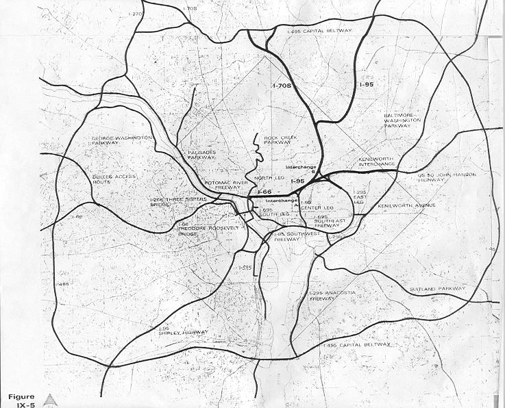
The Anacostia River could be one of the most iconic urban waterways in the US, but instead it is blockaded on both shores by freeways. DC/Interstate 295 cuts off the east bank virtually the entire length of the river in the District, and the Southeast Freeway blocks of Boathouse Row on the west bank.
One of my chief complaints about the use of land in the District of Columbia is the gross underutilization of river frontage. And something must be done to make the river more accessible. Removing the highways, however, would raise strong concerns over dumping what might otherwise be freeway through traffic onto city streets, which, as we've seen on New York Avenue between the 395 tunnel and 295, can turn a city boulevard into a traffic sewer.
Removing highways diminishes induced demand, thus reducing vehicular traffic through the area. For the most part, I don't believe this to be an excuse for the wholesale removal of all the freeways through the District. The District does not have too many highways, but rather a horribly inefficient highway system that dumps dead-end freeway traffic onto city streets. What needs to be removed are the dead end highways, and what remains should be logically and thoroughly connected to the rest of the city's highway system in a manner that minimizes the highway's physical impact on the cityscape.
Douglas Willinger of A Trip Within the Beltway would be decking over our freeways, which in theory may be the best way to diminish a highway's impact on urban landscape. The obvious downside is, of course, cost. Would it be worth it to deck over the Southeast Freeway between Barney Circle and the 11th Street Bridge? Only if the plan included extending the Southeast Freeway past Barney Circle, conducive to the original plan for freeways in the District of Columbia. That full plan, for the record, was not exactly in line with city's current movement toward smart growth (to say the least). Otherwise, we are decking over a largely useless stretch of freeway that ultimately dead ends, dumping freeway traffic on Pennsylvania Avenue.
Another option would be one that I had suggested back over the summer, building the Barney Circle Bridge. This plan, which also called for boulevardization of part of the Anacostia Freeway, might be a good alternative, but it would be cumbersome and expensive to implement. I also foresee this plan going through but without the boulevardization of the Anacostia Freeway, which would go against the notion of making the river more accessible.
The 1.39 mile section of the Southeast Freeway east of the 11th Street Bridge (unsigned but designated Interstate 695) is six lane freeway becomes a two lane access road to RFK Stadium as it passes under Pennsylvania Avenue, and the only purpose this route currently serves is getting traffic to the Sousa Bridge. I use it regularly to get to northbound 295 when I am driving out of the city (there is currently no access from the southbound 11th Street Bridge to northbound 295). JD Land offers insight to the fate of this route. In the plan, the virtually useless ramps from the Bridge to the RFK access road will be completely removed, and that portion of freeway will be replaced by a boulevard.
What about the aforementioned problem of inefficient freeways lacking logical connectivity? Removal of this section of highway could ostensibly be completely mitigated with a couple of ramps which, in my opinion, should have been built decades ago. Ramps between the 11th Street Bridge and the northern route DC 295, along with a ramp from southbound 295 to westbound Pennsylvania Avenue would create a more functional, logical, and efficient highway network, making the undesirable section of the Southeast Freeway virtually obsolete, as it would have all the same functionality of the freeway it parallels on the east bank of the river. Below shows the three new ramps in pink, and the obsolete (ready for boulevardization) stretch of freeway in green.
View Larger Map
I don't have statistics, but I imagine that construction and upkeep for three new ramps would be more than offset by the economic development that highway removal could ostensibly bring to that stretch. The result: less through traffic on city streets like Pennsylvania Avenue and South Capitol Street, no induced traffic, and an overall reduction in vehicle miles traveled.
And Boathouse Row on M St. SE is now accessible to the rest of the adjacent neighborhood, right? Well, no, not exactly.
There is still another bulwark: the CSX line. Certainly, it is much easier to build an at-grade crossing for these railroad tracks which parallel the highway before going underground at the 11th Street Bridge. However the physical and psychological barrier between the river and the neighborhood will remain an impact of developing this area to its full potential as premier riverfront destination.
So is removal of this stretch of freeway worth it? Absolutely. But better connectivity between the remaining freeways is constructed and plans to remove, deck, or realign the CSX track must be devised. Removing an urban freeway is often very good for a city, but the plan must go far beyond simply the physical removal of the roadway. In Near Southeast, simply removing the highway will not be enough for the neighborhood to achieve its full urban potential.
One of my chief complaints about the use of land in the District of Columbia is the gross underutilization of river frontage. And something must be done to make the river more accessible. Removing the highways, however, would raise strong concerns over dumping what might otherwise be freeway through traffic onto city streets, which, as we've seen on New York Avenue between the 395 tunnel and 295, can turn a city boulevard into a traffic sewer.
Removing highways diminishes induced demand, thus reducing vehicular traffic through the area. For the most part, I don't believe this to be an excuse for the wholesale removal of all the freeways through the District. The District does not have too many highways, but rather a horribly inefficient highway system that dumps dead-end freeway traffic onto city streets. What needs to be removed are the dead end highways, and what remains should be logically and thoroughly connected to the rest of the city's highway system in a manner that minimizes the highway's physical impact on the cityscape.
Douglas Willinger of A Trip Within the Beltway would be decking over our freeways, which in theory may be the best way to diminish a highway's impact on urban landscape. The obvious downside is, of course, cost. Would it be worth it to deck over the Southeast Freeway between Barney Circle and the 11th Street Bridge? Only if the plan included extending the Southeast Freeway past Barney Circle, conducive to the original plan for freeways in the District of Columbia. That full plan, for the record, was not exactly in line with city's current movement toward smart growth (to say the least). Otherwise, we are decking over a largely useless stretch of freeway that ultimately dead ends, dumping freeway traffic on Pennsylvania Avenue.
Another option would be one that I had suggested back over the summer, building the Barney Circle Bridge. This plan, which also called for boulevardization of part of the Anacostia Freeway, might be a good alternative, but it would be cumbersome and expensive to implement. I also foresee this plan going through but without the boulevardization of the Anacostia Freeway, which would go against the notion of making the river more accessible.
The 1.39 mile section of the Southeast Freeway east of the 11th Street Bridge (unsigned but designated Interstate 695) is six lane freeway becomes a two lane access road to RFK Stadium as it passes under Pennsylvania Avenue, and the only purpose this route currently serves is getting traffic to the Sousa Bridge. I use it regularly to get to northbound 295 when I am driving out of the city (there is currently no access from the southbound 11th Street Bridge to northbound 295). JD Land offers insight to the fate of this route. In the plan, the virtually useless ramps from the Bridge to the RFK access road will be completely removed, and that portion of freeway will be replaced by a boulevard.
What about the aforementioned problem of inefficient freeways lacking logical connectivity? Removal of this section of highway could ostensibly be completely mitigated with a couple of ramps which, in my opinion, should have been built decades ago. Ramps between the 11th Street Bridge and the northern route DC 295, along with a ramp from southbound 295 to westbound Pennsylvania Avenue would create a more functional, logical, and efficient highway network, making the undesirable section of the Southeast Freeway virtually obsolete, as it would have all the same functionality of the freeway it parallels on the east bank of the river. Below shows the three new ramps in pink, and the obsolete (ready for boulevardization) stretch of freeway in green.
View Larger Map
I don't have statistics, but I imagine that construction and upkeep for three new ramps would be more than offset by the economic development that highway removal could ostensibly bring to that stretch. The result: less through traffic on city streets like Pennsylvania Avenue and South Capitol Street, no induced traffic, and an overall reduction in vehicle miles traveled.
And Boathouse Row on M St. SE is now accessible to the rest of the adjacent neighborhood, right? Well, no, not exactly.
There is still another bulwark: the CSX line. Certainly, it is much easier to build an at-grade crossing for these railroad tracks which parallel the highway before going underground at the 11th Street Bridge. However the physical and psychological barrier between the river and the neighborhood will remain an impact of developing this area to its full potential as premier riverfront destination.
So is removal of this stretch of freeway worth it? Absolutely. But better connectivity between the remaining freeways is constructed and plans to remove, deck, or realign the CSX track must be devised. Removing an urban freeway is often very good for a city, but the plan must go far beyond simply the physical removal of the roadway. In Near Southeast, simply removing the highway will not be enough for the neighborhood to achieve its full urban potential.
Tuesday, November 18, 2008
Casual Observation
If you're taking the freeway that runs between the Douglass and Sousa Bridges, it's the Anacostia Freeway. But if you keep driving north, people will refer to what ultimately becomes the Baltimore Washington Parkway as simply "295". In Bethesda, it's Wisconsin Avenue, then it becomes Rockville Pike, but further north nobody calls it Hungerford Drive or Frederick Road... simply "355".
This has always bugged me. It seems that the further away from good urbanism you get, the more major roads are called by their route number instead of their name. I have often thought of this strange fact to be a symptom of bad urbanism. Close in freeways and arterials have common street names by which they are referred, like the Southeast Freeway, New York Avenue, Shirley Highway, and the Beltway. But sprawl areas tend to latch on to the rural custom of referring to just the route, like 198, 28, or 97, referring to the Maryland routes. But this even happens with routes that came with the sprawl, and weren't there when the areas were rural, like I-97, MD-100, and VA-28, which on large portions aren't even given another name.
Why do I think about crazy things like this? I live off of Route 1 (which fits this pattern for the most part). Even I never say "Baltimore Avenue". I have even incorrectly referred to it as Baltimore Boulevard when trying to remember the actual street name!
I wonder if encouraging colloquial street names might have a positive impact on good urbanism? If "East-West Highway" were renamed, say, Hyatt Avenue (i.e. after the founder of Hyattsville) perhaps it would have a psychological effect on what sort of growth developers would push there. East-West Highway sounds like a great place for a Wal-Mart and an office park, whereas Hyatt Avenue sounds more like sidewalk cafes and brick walk-ups. Okay, that's pushing it a bit, but I'm just trying to think outside the box here.
Traditionally, urban streets have odonyms like "Avenue" and "Street". Should we promote these in our inner suburbs over "Highway" and "Road"? I think it has the potential to add to sense of place. Anyone have thoughts on how we ought to name our streets?
This has always bugged me. It seems that the further away from good urbanism you get, the more major roads are called by their route number instead of their name. I have often thought of this strange fact to be a symptom of bad urbanism. Close in freeways and arterials have common street names by which they are referred, like the Southeast Freeway, New York Avenue, Shirley Highway, and the Beltway. But sprawl areas tend to latch on to the rural custom of referring to just the route, like 198, 28, or 97, referring to the Maryland routes. But this even happens with routes that came with the sprawl, and weren't there when the areas were rural, like I-97, MD-100, and VA-28, which on large portions aren't even given another name.
Why do I think about crazy things like this? I live off of Route 1 (which fits this pattern for the most part). Even I never say "Baltimore Avenue". I have even incorrectly referred to it as Baltimore Boulevard when trying to remember the actual street name!
I wonder if encouraging colloquial street names might have a positive impact on good urbanism? If "East-West Highway" were renamed, say, Hyatt Avenue (i.e. after the founder of Hyattsville) perhaps it would have a psychological effect on what sort of growth developers would push there. East-West Highway sounds like a great place for a Wal-Mart and an office park, whereas Hyatt Avenue sounds more like sidewalk cafes and brick walk-ups. Okay, that's pushing it a bit, but I'm just trying to think outside the box here.
Traditionally, urban streets have odonyms like "Avenue" and "Street". Should we promote these in our inner suburbs over "Highway" and "Road"? I think it has the potential to add to sense of place. Anyone have thoughts on how we ought to name our streets?
I Thought Crime Took Transit?
Last month, the ridiculous argument that transit brings crime into the innocent little suburbs was revisited in response to this article in Freakonomics. More recently, Just Up the Pike followed a shooting that occurred on a Silver Spring bus recently, prompting more discussion on the possibility that mass transit has an effect on crime.
I eventually had to defend this argument to a good friend of mine who happens to be a Baltimore City police officer. His anecdotal claim: the subway in Baltimore has done absolutely nothing to positively impact the safety of the surrounding areas, and if anything has made them worse.
I argue that it has more to do with the bad urbanism for which the Baltimore Metro is now notorious. I believe even bad transit can positively impact crime rates in many cases, if for no other reason than by potentially lowering the cost of living. But perhaps the fact of the presence of transit has no impact on crime whatsoever, perhaps the onus lies entirely on the good urbanism that ought to come with transit. Maybe large, spread out parking lots are what really draw crime. Many transit stations have those, and it's bad urbanism. I certainly feel much safer getting off at Gallery Place late at night versus Greenbelt for that reason.
Recently, some federal employees at Fort Meade received an email alert cautioning them to stay away from Arundel Mills Mall after dark. Think about that: stay away from the largest shopping center in Central Maryland while the holiday shopping rush looms upon us. Why? Inside Charm City points toward this Baltimore Sun article that tells of a woman and her young child being robbed at gunpoint in the parking lot. Most disturbing is the fact that police believe that this crime is unrelated to two other robberies that took place around the giant oasis of auto-oriented commerce near the MD-100 interchange with the Baltimore-Washington Parkway. I did some further pecking and found another Sun article published just Thursday. There have been five robberies in the Arundel Mills parking lot in just the last month. Concerns over the robberies were echoed on MyFoxDC.
Urbanism doesn't get much worse than at Arundel Mills:
View Larger Map
But in most of the robberies reported there, did the criminals hop on the light rail back to Baltimore city? No, they hopped into a car and then disappeared into traffic. But no one ever says "That new highway is going to bring more crime!"
I eventually had to defend this argument to a good friend of mine who happens to be a Baltimore City police officer. His anecdotal claim: the subway in Baltimore has done absolutely nothing to positively impact the safety of the surrounding areas, and if anything has made them worse.
I argue that it has more to do with the bad urbanism for which the Baltimore Metro is now notorious. I believe even bad transit can positively impact crime rates in many cases, if for no other reason than by potentially lowering the cost of living. But perhaps the fact of the presence of transit has no impact on crime whatsoever, perhaps the onus lies entirely on the good urbanism that ought to come with transit. Maybe large, spread out parking lots are what really draw crime. Many transit stations have those, and it's bad urbanism. I certainly feel much safer getting off at Gallery Place late at night versus Greenbelt for that reason.
Recently, some federal employees at Fort Meade received an email alert cautioning them to stay away from Arundel Mills Mall after dark. Think about that: stay away from the largest shopping center in Central Maryland while the holiday shopping rush looms upon us. Why? Inside Charm City points toward this Baltimore Sun article that tells of a woman and her young child being robbed at gunpoint in the parking lot. Most disturbing is the fact that police believe that this crime is unrelated to two other robberies that took place around the giant oasis of auto-oriented commerce near the MD-100 interchange with the Baltimore-Washington Parkway. I did some further pecking and found another Sun article published just Thursday. There have been five robberies in the Arundel Mills parking lot in just the last month. Concerns over the robberies were echoed on MyFoxDC.
Urbanism doesn't get much worse than at Arundel Mills:
View Larger Map
But in most of the robberies reported there, did the criminals hop on the light rail back to Baltimore city? No, they hopped into a car and then disappeared into traffic. But no one ever says "That new highway is going to bring more crime!"
Tuesday, November 11, 2008
Thank Your Veterans by Lobbying for Better Bases
Today is Veteran's Day, and I encourage all of you to thank your veterans for serving. We live in an area rich with military tradition, and it is important to remember the millions of men and women who have served our country either voluntarily or as conscripts. They fought wars so we wouldn't have to fight them on our own soil, and they continue to serve selflessly today. No matter what your opinions on the current wars may be, I believe we should all be thankful for the soldiers we have willing to fight them.
I'll also take this opportunity to encourage lobbying the Federal Government and the Department of Defense for more economical use of their lands. As I have mentioned in the past, some of America's most deleterious use of land happens in and around military bases. Particularly in our region, places like Andrews AFB, Bolling AFB, Fort Meade, Fort Belvoir, Quantico MCB, NAS Anacostia, and of course the Pentagon have some of the most uneconomical, pollution-causing land use policies.
As I continue my fight from the inside to improve transit, pedestrian, and environmental policies on Fort Meade, I ask anyone who works at any of the other military bases to fight for them at their locations. When bases are set up in suburban-style sprawl, a great deal of the cost associated with that is passed on to the taxpayers: utilities, fuel for civil service vehicles, land acquisition, parking lots, road widening, traffic, and pollution, to name a few. The best thing we can do for our veterans is to give them better living and training facilities, help them not need to own a car, and clean up their natural environment by demanding better planning for military bases.
***
In other news, I would like to let everyone know that I am now writing semi-regularly for GreaterGreaterWashington, and a couple of my recent posts have been cross-posted there. Since I'm sure I have very few readers that don't read GGW, I'm sure you already knew that. But in case you've never read GGW, I highly recommend it as a source for information, links, and analysis about urban planning and local issues for the DC metropolitan area, and I'm grateful to be a part of it.
I'll also take this opportunity to encourage lobbying the Federal Government and the Department of Defense for more economical use of their lands. As I have mentioned in the past, some of America's most deleterious use of land happens in and around military bases. Particularly in our region, places like Andrews AFB, Bolling AFB, Fort Meade, Fort Belvoir, Quantico MCB, NAS Anacostia, and of course the Pentagon have some of the most uneconomical, pollution-causing land use policies.
As I continue my fight from the inside to improve transit, pedestrian, and environmental policies on Fort Meade, I ask anyone who works at any of the other military bases to fight for them at their locations. When bases are set up in suburban-style sprawl, a great deal of the cost associated with that is passed on to the taxpayers: utilities, fuel for civil service vehicles, land acquisition, parking lots, road widening, traffic, and pollution, to name a few. The best thing we can do for our veterans is to give them better living and training facilities, help them not need to own a car, and clean up their natural environment by demanding better planning for military bases.
***
In other news, I would like to let everyone know that I am now writing semi-regularly for GreaterGreaterWashington, and a couple of my recent posts have been cross-posted there. Since I'm sure I have very few readers that don't read GGW, I'm sure you already knew that. But in case you've never read GGW, I highly recommend it as a source for information, links, and analysis about urban planning and local issues for the DC metropolitan area, and I'm grateful to be a part of it.
Monday, November 3, 2008
Are You Ready For Some Metro
 Monday Night Football, the NFL's major prime time network(-cum-basic-cable) broadcast has come to FedEx Field once again. Even more exciting than the normal hyperbole of MNF game is the fact that the 6-2 Redskins are playing the 5-2 Pittsburgh Steelers, a game that lots of people are actually going to care about for a change. Redskins Nation is buzzing.
If you commute on the eastern half of the Beltway, however, your afternoon drive will probably be much slower, as FedEx Field opens the lots four hours before the 9 pm kickoff and tailgaters will likely be jamming exits 15, 16, and 17 during the evening rush, as happens for every weeknight home game at FedEx Field. But Metro is pulling their weight, just like they did for the last Monday Night game at FedEx, the 2006 season opener. The system will be staying open until 1 a.m., with additional personnel at Morgan Boulevard and Largo stations.
Considering that FedEx Field opened in 1997 but Morgan Boulevard and Largo stations did not open until 2004, Metro use during mega-events at the stadium does not make headlines like Nationals Park did when it opened atop a Green Line station this spring. People took notice that Nationals games were not choking the Metro system, even when Nationals games were getting high attendance at the beginning of the season (interest naturally waned by the middle of their dismal 59-102 season).
Of course, FedEx Field has over twice the capacity of Nationals Park. Then again, FedEx Field is suburban, fed by highways, and surrounded by acres of surface parking. Where Navy Yard station is a block from Nats Park, FedEx Field lies almost a mile from Morgan Boulevard. Even if one were to envision a future Purple Line station at FedEx Field, it wouldn't be much closer, and would likely augment rather than replace Morgan Boulevard as the primary stop for the venue. In any event, an awful lot of people would have to give up driving before Metro started to have major issues on game day, even when games impacted the weekday rush hour. For now, the Blue Line is a viable alternative to driving. I'll take walking a four fifths of a mile for free from the Metro over walking two fifths of a mile from a $30 parking space. And it never hurts to take a car off the Beltway, while you're at it.
Tuesday, October 28, 2008
Stupid Growth: The CCC
When the Arc and the Dove landed on the shores of the lower Potomac in 1634, Southern Maryland was as pristine as it had ever been. Beautiful estuaries, diverse flora and fauna,
and verdant landscapes have always highlighted the area, and they no doubt helped contribute to the success of the first European colony in Maryland.
Most recently, parts of Charles, Calvert, and Saint Mary's County have come to look more like the off-the-highway towns I came to know in the remote parts of the Midwest back in my Army days. Car culture, big boxes, and inefficient land use has taken its toll in places like Waldorf and Dunkirk, and the effects are spreading. Vital wetlands in the Potomac and Patuxent watersheds are bearing the brunt of the ecological damage.
And now a new highway is moving forward.
The Charles County Connector. Consider it the baby brother of the ICC. And thanks to the big brother, you're not likely to hear anything about it. I myself have had a difficult time finding up-to-date information on this highway, but I managed to dig up an old National Environmental Policy Act report (warning: PDF).
 I first heard of this freeway through a colleague of mine who is a member of the Maryland Ornithological Society. The group is of course concerned about the outright destruction the vital wetlands of the Mattawoman Creek as well as increasing impervious surfaces that will feed polluted water into the wetlands, home to scores of species of Maryland birds. These concerns are shared directly by the Mattawoman Watershed Society, who is urging people to write the governor in opposition of the plan. In all, the four-mile, $60m highway would require the destruction of 74 acres of forest and 7.5 acres of wetland. Much of the surrounding area is slated for development upon completion of the new road.
Tim Wheeler at the Baltimore Sun's Bay and Environment blog points out that this deleterious construction would be carried out under the guise of the Maryland Smart Growth initiatives. This to me is incredibly bizarre and most frustrating. Obviously, keeping development in the northern portion of Charles County makes sense for a number of reasons. It is closer to DC, there are larger towns (Waldorf, LaPlata) that are already somewhat developed, and there are ample road and utility connections already present. But smart growth by definition would dictate that development would take place in and around those towns, not in brand new developments around them. Smart growth implies LESS use of the automobile, quite contrary to the notion of constructing a highway.
Granted I have only skimmed the NEPA report, but nowhere have I seen any plans for sidewalks, trails, or transit along the highway. Of course, If they are there, they may get canceled for "environmental impact" reasons like the ironic fate of the ICC bike trail.
For those that argue that they need the highway to alleviate traffic in the area, consider the following analogy: building highways to alleviate traffic is like scratching poison Ivy to get rid of the irritation. It will be better for a short while, but ultimately you are only spreading the problem. Perhaps before Charles County partitions and destroys its most valuable resource, denser construction and transit around Waldorf ought to be considered. That's real smart growth. And if they do, perhaps Southern Maryland will keep a bit more of its idyllic charm from getting eaten up by cul-de-sacs and parking lots. And perhaps my friend from work will be able to spot a common snipe on the Mattawoman for years to come.
and verdant landscapes have always highlighted the area, and they no doubt helped contribute to the success of the first European colony in Maryland.
Most recently, parts of Charles, Calvert, and Saint Mary's County have come to look more like the off-the-highway towns I came to know in the remote parts of the Midwest back in my Army days. Car culture, big boxes, and inefficient land use has taken its toll in places like Waldorf and Dunkirk, and the effects are spreading. Vital wetlands in the Potomac and Patuxent watersheds are bearing the brunt of the ecological damage.
And now a new highway is moving forward.
The Charles County Connector. Consider it the baby brother of the ICC. And thanks to the big brother, you're not likely to hear anything about it. I myself have had a difficult time finding up-to-date information on this highway, but I managed to dig up an old National Environmental Policy Act report (warning: PDF).
 I first heard of this freeway through a colleague of mine who is a member of the Maryland Ornithological Society. The group is of course concerned about the outright destruction the vital wetlands of the Mattawoman Creek as well as increasing impervious surfaces that will feed polluted water into the wetlands, home to scores of species of Maryland birds. These concerns are shared directly by the Mattawoman Watershed Society, who is urging people to write the governor in opposition of the plan. In all, the four-mile, $60m highway would require the destruction of 74 acres of forest and 7.5 acres of wetland. Much of the surrounding area is slated for development upon completion of the new road.
Tim Wheeler at the Baltimore Sun's Bay and Environment blog points out that this deleterious construction would be carried out under the guise of the Maryland Smart Growth initiatives. This to me is incredibly bizarre and most frustrating. Obviously, keeping development in the northern portion of Charles County makes sense for a number of reasons. It is closer to DC, there are larger towns (Waldorf, LaPlata) that are already somewhat developed, and there are ample road and utility connections already present. But smart growth by definition would dictate that development would take place in and around those towns, not in brand new developments around them. Smart growth implies LESS use of the automobile, quite contrary to the notion of constructing a highway.
Granted I have only skimmed the NEPA report, but nowhere have I seen any plans for sidewalks, trails, or transit along the highway. Of course, If they are there, they may get canceled for "environmental impact" reasons like the ironic fate of the ICC bike trail.
For those that argue that they need the highway to alleviate traffic in the area, consider the following analogy: building highways to alleviate traffic is like scratching poison Ivy to get rid of the irritation. It will be better for a short while, but ultimately you are only spreading the problem. Perhaps before Charles County partitions and destroys its most valuable resource, denser construction and transit around Waldorf ought to be considered. That's real smart growth. And if they do, perhaps Southern Maryland will keep a bit more of its idyllic charm from getting eaten up by cul-de-sacs and parking lots. And perhaps my friend from work will be able to spot a common snipe on the Mattawoman for years to come.
Tuesday, October 14, 2008
Fairfax County In the Red
58.2 million dollars is the total. Huge cuts are being made. Huge budget cuts are being made. Plummeting home values are exacerbating the problem by severely reducing the county's tax base. It's a scary prospect. WTOP reported that the school system is making drastic cuts. NBC's 11 o'clock news said that the county is going to nix new vehicles for county fire, police, and ambulance services.
Fairfax County is one of the wealthiest jurisdictions in the United States.
Something that draws me to the study of urban planning is the way the landscape can affect every other facet of the human existence. I wonder how much more stable property values would be if Tysons Corner already had its master plan realized. I wonder how much cheaper emergency services would be if the county was organized into concise, navigable, interconnected neighborhoods. I wonder how much extra money the average Fairfax resident would have if they didn't need to own a car to make their ends meet.
I will not claim to have anything beyond a very rudimentary rudimentary understanding of economics, nor have I ever lived in Fairfax County, but hearing news like this is somewhat disconcerting, particularly when I find myself being hit by uncertain financial times. I see my state burning money on infrastructural projects that will further encourage a region of people to accept poor choices in land use as the status quo.
Fairfax County is one of the wealthiest jurisdictions in the United States.
Something that draws me to the study of urban planning is the way the landscape can affect every other facet of the human existence. I wonder how much more stable property values would be if Tysons Corner already had its master plan realized. I wonder how much cheaper emergency services would be if the county was organized into concise, navigable, interconnected neighborhoods. I wonder how much extra money the average Fairfax resident would have if they didn't need to own a car to make their ends meet.
I will not claim to have anything beyond a very rudimentary rudimentary understanding of economics, nor have I ever lived in Fairfax County, but hearing news like this is somewhat disconcerting, particularly when I find myself being hit by uncertain financial times. I see my state burning money on infrastructural projects that will further encourage a region of people to accept poor choices in land use as the status quo.
Monday, October 6, 2008
Ambitious Transit Advocacy
I really liked a point Ryan Avent made this week:
This is an excellent point, and one that ought to be further explored within the DC metropolitan region. We can build roads to support future development, but rails? Forget it. Furthering this point, Richard Layman had a good post on the sort of fundamental paradigm shifts we will to need to undergo in order to take the economic and environmental burden out of transit provision.
But if we could build rails anticipating future developments, I believe areas such as incorporated, close-in, traditionally-built suburban towns ought to be among the to speculate transit expansions. Incorporated towns because the local government may have a shorter route to approving smarter development around transit, close in so that they are relevant to the heart of the transit system, and traditionally-built neighborhoods because the open connectivity is conducive to residents reaching the transit station. Places like Hyattsville, Takoma Park, Kensington, Falls Church, and Forest Heights ought to be considered for such speculation.
 I have been toying around in Google Earth trying to imagine a transit system for the DC area that would make it easy to live anywhere in the region without a car, much like Manhattan. It is probably not a very feasible system, with 14 lines and 550+ miles of heavy and light rail track, plus the fact that my quasi-scientific formulas for designing my system have no way of predicting ridership or optimal routes. But I'm kind of curious as to why the DC metropolitan area and other cities aren't advocating for such a system that takes cars off the roads.
The extremely ambitious highway plan of half a century ago makes such a system of passenger trains seem rather small. Freeway revolts nixed much of the more detrimental inner city freeways, however much of the freeway infrastructure in our region has come to fruition. Remember, freeways don't necessarily have to be interstates (much like Metro doesn't necessarily have to be heavy rail, it can be light rail)
Below, I've listed the limited access divided freeways of our region (DC, plus Montgomery, Prince George's, Arlington, Fairfax and northeastern Prince William County and Alexandria City) Lengths approximate:
Mostly or completely pure freeway:
I-95 Maryland (College Park to Howard County) 8 miles
MD/DC-295, Balt-Wash Parkway (Anacostia to Fort Meade) 21 miles
I-495, Capital Beltway (loop around the city) 66 miles
I-270 (Bethesda to Frederick) 33 miles
I-95/395, Shirley Highway (Dale City to Downtown) 26 miles
I-295, Anacostia/Southeast Freeway (Oxon Hill to Downtown) 8 miles
Suitland Parkway (Anacostia to Andrews AFB) 10 miles
US-50, John Hanson Highway (Cheverly to Annapolis) 25 miles
US-50, Arlington Boulevard (Merrifield to The Mall) 11 miles
I-66 Custis Memorial Freeway (Gainesville to The Mall) 32 miles
Clara Barton Parkway (Georgetown to Potomac, MD) 10 miles
I-370/MD-200, Intercounty Connector (Gaithersburg to Laurel, under construction) 18 miles
George Washington Memorial Parkway (Alexandria to Great Falls) 15 miles
Dulles Toll Road/Greenway (Arlington to Loudon County) 16 miles
Key Br/Whitehurst Fwy/Potomac River Fwy (Rosslyn to The Mall) 2 miles
US-29, Columbia Pike (Silver Spring to Howard County) 11 miles
MD-4 Pennsylvania Avenue (Suitland to Anne Arundel County) 11 miles
MD-5 Branch Avenue (Suitland to Brandywine) 12 miles
VA-28 Sully Road (Manassas to Dulles International Airport) 21 miles
Montrose Parkway (Rockville) 4 Miles
Rock Creek Parkway (Woodley Park to The Mall) 3 miles
Rapidly becoming pure freeways:
US-301, Blue Star Memorial Highway (Bowie to Waldorf) 26 miles
MD-210, Indian Head Highway (Forest Heights to Accokeek) 11 miles
VA-7100, Fairfax County Parkway (Herndon to Springfield) 35 miles
VA-3000, Prince William Parkway (Woodbridge to Manassas) 16 miles
451 miles of freeway in Washington DC and adjacent counties. Sure makes the downtown sections that didn't get built seem like small apples. This doesn't include "mini freeways" embedded into the traffic system. It does not include the express tunnels on North Capitol, South Capitol, Connecticut Avenue, Massachusetts Avenue, or K Street. Nor do they include spur freeways like the Cabin John Parkway, 270 spur, Spout Run Parkway, or the E Street Expressway. Nor does it include roads that become freeways for short stretches, like Central Avenue in Largo, Military Road west of 14th Street, North Capitol Street north of the Hospitals, or Franconia Road in Springfield. Nor does it include interchanges at non-freeways, like Tyson's Corner, Glenmont, University Boulevard at Route 1, or Kingle Road. Nor does it take into account express lanes, HOV lanes, or exit ramps. I figure all of this combined ought to add up to at least 100 miles.
I'm curious about the percentage of area residents that live within walking distance to fixed transit versus the percentage of area residents that live within walking distance to a freeway or an interchange. I'd be willing to bet that the latter is the larger number. If highways can have their 550 miles of coverage, why not rails?
Perhaps highway advocates threw a bunch of ideas at the wall to see what stuck. Perhaps it was the relentless lobbying. But whatever it is, it is the highway lobby had more ambition than our current transit advocacy currently exudes. If we can emulate one thing from the freeway lobby of the mid-20th Century, it is the ambitious fortitude with which they lobbied for what ultimately became the largest public works project in world history.
I'm not going to settle for a transit system that doesn't allow most of the metropolitan area to survive without an automobile. I'm going to keep pushing for my 550 miles of fixed rail.
The point that highways are built speculatively all the time while transit is not is a very good one, and one which never fails to get my goat. But I think it’s worth emphasizing that speculative transit isn’t really about building lines into the wilderness. It’s about building lines into places people already live in order to take better advantage of valuable land there.
For instance, if we imagine a sunbelt boomtown, it’s easy to see an exurban ring road being built to accommodate “future development.” At the same time, a rail transit system through the downtown area would be nixed in a heartbeat because that area lacked an appropriate density for transit. But transportation linkages shape development whether they’re road or rail. When you fail to use the same speculative criteria for one mode that you do for another, you are making a judgment about what kind of development is appropriate. For decades, government has essentially said that in the overwhelming majority of cases, auto-oriented development is appropriate and nothing else. Considering the effects of that decision, it must be one of the most momentous government interventions of all time.
This is an excellent point, and one that ought to be further explored within the DC metropolitan region. We can build roads to support future development, but rails? Forget it. Furthering this point, Richard Layman had a good post on the sort of fundamental paradigm shifts we will to need to undergo in order to take the economic and environmental burden out of transit provision.
But if we could build rails anticipating future developments, I believe areas such as incorporated, close-in, traditionally-built suburban towns ought to be among the to speculate transit expansions. Incorporated towns because the local government may have a shorter route to approving smarter development around transit, close in so that they are relevant to the heart of the transit system, and traditionally-built neighborhoods because the open connectivity is conducive to residents reaching the transit station. Places like Hyattsville, Takoma Park, Kensington, Falls Church, and Forest Heights ought to be considered for such speculation.
 I have been toying around in Google Earth trying to imagine a transit system for the DC area that would make it easy to live anywhere in the region without a car, much like Manhattan. It is probably not a very feasible system, with 14 lines and 550+ miles of heavy and light rail track, plus the fact that my quasi-scientific formulas for designing my system have no way of predicting ridership or optimal routes. But I'm kind of curious as to why the DC metropolitan area and other cities aren't advocating for such a system that takes cars off the roads.
The extremely ambitious highway plan of half a century ago makes such a system of passenger trains seem rather small. Freeway revolts nixed much of the more detrimental inner city freeways, however much of the freeway infrastructure in our region has come to fruition. Remember, freeways don't necessarily have to be interstates (much like Metro doesn't necessarily have to be heavy rail, it can be light rail)
Below, I've listed the limited access divided freeways of our region (DC, plus Montgomery, Prince George's, Arlington, Fairfax and northeastern Prince William County and Alexandria City) Lengths approximate:
Mostly or completely pure freeway:
I-95 Maryland (College Park to Howard County) 8 miles
MD/DC-295, Balt-Wash Parkway (Anacostia to Fort Meade) 21 miles
I-495, Capital Beltway (loop around the city) 66 miles
I-270 (Bethesda to Frederick) 33 miles
I-95/395, Shirley Highway (Dale City to Downtown) 26 miles
I-295, Anacostia/Southeast Freeway (Oxon Hill to Downtown) 8 miles
Suitland Parkway (Anacostia to Andrews AFB) 10 miles
US-50, John Hanson Highway (Cheverly to Annapolis) 25 miles
US-50, Arlington Boulevard (Merrifield to The Mall) 11 miles
I-66 Custis Memorial Freeway (Gainesville to The Mall) 32 miles
Clara Barton Parkway (Georgetown to Potomac, MD) 10 miles
I-370/MD-200, Intercounty Connector (Gaithersburg to Laurel, under construction) 18 miles
George Washington Memorial Parkway (Alexandria to Great Falls) 15 miles
Dulles Toll Road/Greenway (Arlington to Loudon County) 16 miles
Key Br/Whitehurst Fwy/Potomac River Fwy (Rosslyn to The Mall) 2 miles
US-29, Columbia Pike (Silver Spring to Howard County) 11 miles
MD-4 Pennsylvania Avenue (Suitland to Anne Arundel County) 11 miles
MD-5 Branch Avenue (Suitland to Brandywine) 12 miles
VA-28 Sully Road (Manassas to Dulles International Airport) 21 miles
Montrose Parkway (Rockville) 4 Miles
Rock Creek Parkway (Woodley Park to The Mall) 3 miles
Rapidly becoming pure freeways:
US-301, Blue Star Memorial Highway (Bowie to Waldorf) 26 miles
MD-210, Indian Head Highway (Forest Heights to Accokeek) 11 miles
VA-7100, Fairfax County Parkway (Herndon to Springfield) 35 miles
VA-3000, Prince William Parkway (Woodbridge to Manassas) 16 miles
451 miles of freeway in Washington DC and adjacent counties. Sure makes the downtown sections that didn't get built seem like small apples. This doesn't include "mini freeways" embedded into the traffic system. It does not include the express tunnels on North Capitol, South Capitol, Connecticut Avenue, Massachusetts Avenue, or K Street. Nor do they include spur freeways like the Cabin John Parkway, 270 spur, Spout Run Parkway, or the E Street Expressway. Nor does it include roads that become freeways for short stretches, like Central Avenue in Largo, Military Road west of 14th Street, North Capitol Street north of the Hospitals, or Franconia Road in Springfield. Nor does it include interchanges at non-freeways, like Tyson's Corner, Glenmont, University Boulevard at Route 1, or Kingle Road. Nor does it take into account express lanes, HOV lanes, or exit ramps. I figure all of this combined ought to add up to at least 100 miles.
I'm curious about the percentage of area residents that live within walking distance to fixed transit versus the percentage of area residents that live within walking distance to a freeway or an interchange. I'd be willing to bet that the latter is the larger number. If highways can have their 550 miles of coverage, why not rails?
Perhaps highway advocates threw a bunch of ideas at the wall to see what stuck. Perhaps it was the relentless lobbying. But whatever it is, it is the highway lobby had more ambition than our current transit advocacy currently exudes. If we can emulate one thing from the freeway lobby of the mid-20th Century, it is the ambitious fortitude with which they lobbied for what ultimately became the largest public works project in world history.
I'm not going to settle for a transit system that doesn't allow most of the metropolitan area to survive without an automobile. I'm going to keep pushing for my 550 miles of fixed rail.
Wednesday, October 1, 2008
An I-95 Train?
I've always wonder what DC would have looked like if they had built all the freeways that had been proposed in the '60s. I'm glad they didn't, but I do have fun driving on urban freeways like the BQE in New York, the Mass Pike in Boston, or the Southeast-Southwest Freeway here in DC. I gripe about how in DC (and Baltimore, for that matter) Freeways basically dead end in the city, dumping ridiculous volumes of automobile traffic in concentrated areas that ought to be more geared toward pedestrians. Either connect them, or get rid of them.
What is now I-395 was supposed to have connected along the Metropolitan Branch train line and connected to the stub at the I-95 interchange in College Park. Instead, it dead ends on New York Avenue, dumping thousands of cars onto what was intended to be a grand boulevard with vistas to the White House. Many of the funds from those abandoned highway projects were ultimately diverted to Metro. But the highway system proposed was far more in-depth than Metro today. Why didn't we match that ambition with trains?
Frankly, I don't care if the Shirley Highway is backed up. That highway is about six lanes wider than it ought to be anyway. I say, get rid of all those HOV lanes in the middle and add another Metro line, perhaps a light rail. Make it useful. Start it in Dale City, and have it run all along 95 and then 395 in the center lanes, all the way up toDC where it can connect underground to L'Enfant Plaza. Virginia commuters would then have the option to eschew the traffic on the freeway with a different kind of high occupancy vehicle: transit. Those giant empty spaces in the middle of highway exits? Throw parking garages in there. Giant park and rides taking tens of thousands of cars off the road every day.
I am curious to see what a study would say might happen if those HOV lanes were replaced with perhaps a light rail track with seamless connectivity to Metro stations (Franconia, Pentagon, and L'Enfant, perhaps).
Maybe this new line could even fight its way through the city and connect to I-95 in College Park, then head on up to Columbia. Sure it would be a long line, but it would do what ambitious freeway planners wanted I-95 to do: connect the region. Only this would be a far more responsible way of doing so.
Normally, I don't believe transit lines should run completely on freeways. I think freeways stifle the ability to place transit-oriented development around stations. I think a rail running along Rt. 1 in Maryland is far superior to one running along I-95, a parallel freeway a few miles west with no chance for promoting the same kind of good urbanism. But the Virginia portion of the above proposal would ostensibly replace a freeway, the one-way HOV lanes from Woodbridge to DC. Could trans move the same number of people during rush hour? They certainly would move people faster, considering they wouldn't have to suffer through Mixing Bowl traffic... they'd just speed right past it.
I wonder, has this proposal ever been thrown out there? Have such studies been conducted? Could a light rail move as many people as the HOV lanes, or would it have to be Metro, or something of even higher capacity?
Moving on from highways is going to take a plan as ambitious and extensive as the plan that put them here in the first place; a plan that can equal or best the largest public works project in human history. Why not start with superfluous lanes on a highway bringing thousands of people into the city every day?
What is now I-395 was supposed to have connected along the Metropolitan Branch train line and connected to the stub at the I-95 interchange in College Park. Instead, it dead ends on New York Avenue, dumping thousands of cars onto what was intended to be a grand boulevard with vistas to the White House. Many of the funds from those abandoned highway projects were ultimately diverted to Metro. But the highway system proposed was far more in-depth than Metro today. Why didn't we match that ambition with trains?
Frankly, I don't care if the Shirley Highway is backed up. That highway is about six lanes wider than it ought to be anyway. I say, get rid of all those HOV lanes in the middle and add another Metro line, perhaps a light rail. Make it useful. Start it in Dale City, and have it run all along 95 and then 395 in the center lanes, all the way up toDC where it can connect underground to L'Enfant Plaza. Virginia commuters would then have the option to eschew the traffic on the freeway with a different kind of high occupancy vehicle: transit. Those giant empty spaces in the middle of highway exits? Throw parking garages in there. Giant park and rides taking tens of thousands of cars off the road every day.
I am curious to see what a study would say might happen if those HOV lanes were replaced with perhaps a light rail track with seamless connectivity to Metro stations (Franconia, Pentagon, and L'Enfant, perhaps).
Maybe this new line could even fight its way through the city and connect to I-95 in College Park, then head on up to Columbia. Sure it would be a long line, but it would do what ambitious freeway planners wanted I-95 to do: connect the region. Only this would be a far more responsible way of doing so.
Normally, I don't believe transit lines should run completely on freeways. I think freeways stifle the ability to place transit-oriented development around stations. I think a rail running along Rt. 1 in Maryland is far superior to one running along I-95, a parallel freeway a few miles west with no chance for promoting the same kind of good urbanism. But the Virginia portion of the above proposal would ostensibly replace a freeway, the one-way HOV lanes from Woodbridge to DC. Could trans move the same number of people during rush hour? They certainly would move people faster, considering they wouldn't have to suffer through Mixing Bowl traffic... they'd just speed right past it.
I wonder, has this proposal ever been thrown out there? Have such studies been conducted? Could a light rail move as many people as the HOV lanes, or would it have to be Metro, or something of even higher capacity?
Moving on from highways is going to take a plan as ambitious and extensive as the plan that put them here in the first place; a plan that can equal or best the largest public works project in human history. Why not start with superfluous lanes on a highway bringing thousands of people into the city every day?
Subscribe to:
Posts (Atom)

 Posts
Posts