The Transport Politic often showcases unique and clever transit solutions visualized by the site's author, Yonah Freemark. Recently he looked into the WMATA system and made an interesting proposal: a separated Blue Line, and running along it, another investment, a so-called Pink Line. Though Freemark's plan would add invaluable capacity and connectivity to our system, I believe a similar vision could be achieved without building another costly Potomac Crossing. That's not to say we shouldn't, but perhaps a closer term solution might look more like this:
View Pink Line in a larger map
The existing Potomac crossing where the Yellow Line connects Downtown and Pentagon City is underutilized and ought to have it's capacity increased before another crossing is built. This alternative combines the cross-Arlington connectivity that Freemark envisions without the circuitous route back through Rosslyn. This investment could be increased even more if the Green and Yellow Lines could be separated downtown, which might prove cheaper than the Blue Line separation. Another advantage would be that this line could just be an extension of the Silver Line, which would eliminate the need for a new line color.
New track miles are most valuable in the core. Unfortunately, they're also generally the most expensive new track miles. But the benefits to the entire region are huge across the entire system, making it a worthwhile investment. And it's about time we started considering "the rest of Arlington" more a part of the core.
Showing posts with label Arlington. Show all posts
Showing posts with label Arlington. Show all posts
Saturday, November 21, 2009

Saturday, February 21, 2009
Lady Bird Johnson Park
I have always thought Lady Bird Johnson Park was a little strange. Though closer to the Virginia shore, this island lies completely within the District, much like Roosevelt Island to the northwest. Although, unlike Roosevelt, this island is overrun with freeway spaghetti, most of it serving the Commonwealth and not the District. Also, this area is served by a Metro station, Arlington Cemetery. There is no residential, commercial, office, or industrial construction on the island, save a small marina on the south end. There are no park facilities. The entire area just seems like a serene setting to plop down a bunch of (confusing) highways.
Considering Lady Bird Johnson's efforts to beautify our nation's freeways, I suppose this is somewhat fitting (and probably intentional). though her Highway Beautification Act pertained mostly to interstates and ironically none of the highways on her island are interstates. Still, it seems like such a waste of a land. Why call it a "park" if there are no park facilities? It's not exactly the kind of place one can picnic or hike.
I would like to see the highway lanes consolidated, perhaps with some modest low rise apartments on the north side of the island oriented to the Metro station. And open the island up with some trails and waterside park facilities. Right now, the District seems to be allowing this land to be utilized only by the commuters in Arlington County.
Considering Lady Bird Johnson's efforts to beautify our nation's freeways, I suppose this is somewhat fitting (and probably intentional). though her Highway Beautification Act pertained mostly to interstates and ironically none of the highways on her island are interstates. Still, it seems like such a waste of a land. Why call it a "park" if there are no park facilities? It's not exactly the kind of place one can picnic or hike.
I would like to see the highway lanes consolidated, perhaps with some modest low rise apartments on the north side of the island oriented to the Metro station. And open the island up with some trails and waterside park facilities. Right now, the District seems to be allowing this land to be utilized only by the commuters in Arlington County.
Friday, January 2, 2009
Imagine Seven Corners
Yikes. Just the thought of an area named "Seven Corners" makes me not want to drive there. Wilson Boulevard, Roosevelt Boulevard, Arlington Boulevard, Leesburg Pike, Broad Street, Sleepy Hollow Road, and Hillwood Avenue all converge in nearly the same place at the southern tip of Falls Church. I have only driven through this area a select few times, always on weekends, and only once on purpose. It is a nightmare. No doubt that in an area named after it's intersection, the intersection would be the most dominant feature of the landscape.
Michael Perkins over at GGW suggested that I use this area to start my New Year's resolution to write more on Virginia... and it couldn't be a more desperate region for a street grid. Serving mostly strip malls and car-dependent medium-density apartments, the roads through this area operate with a series of frontage roads, bridges, and quasi-interchanges. One might argue that this area is too sparse to merit much investment in the road system. But I believe a better working street grid could reduce the painful traffic jams while at the same time accommodating pedestrians and transit, perhaps even catalyzing further growth. Here's what that part of town might look like if it had a better street grid:
View Larger Map
The region could start by improving pedestrian facilities from the East Falls Church Metro station, located just under a mile north of the intersection at Wilson and Roosevelt. Keeping Arlington Boulevard up to its current semi-freeway standard would be possible with lots of overpasses, but of course this would be far more costly. A sunken freeway, however, has far less impact on connectivity than an at-grade route.
Traffic will of course be relieved by the addition of new roads, guiding cars around the disastrous intersection for which the area is named. This approach is known to work better than widening roads, as it cuts down on the number of vehicle miles required for a particular car travel, reduces traffic (particularly if there is an emergency situation blocking one of the roads), and induces more pedestrian travel. The added capacity allows some reduction of automobile capacity on the existing major roads to make way for transit and/or streetscape improvements. In the end, cars, pedestrians, transit riders, residents, and business owners tend to benefit more from well connected streets. Seven Corners would no doubt benefit immediately from reduced traffic jams, before any other changes are made.
Centralized locations such as Seven Corners shouldn't be unsavory destinations because of traffic. With attractions such as the unique Eden Center, a predominantly Vietnamese shopping district on Wilson Boulevard, Seven Corners could be a great destination, not just a clogged interchange out in the burbs. I have limited experience with this location, so strongly encourage comments with suggestions or further information.
Michael Perkins over at GGW suggested that I use this area to start my New Year's resolution to write more on Virginia... and it couldn't be a more desperate region for a street grid. Serving mostly strip malls and car-dependent medium-density apartments, the roads through this area operate with a series of frontage roads, bridges, and quasi-interchanges. One might argue that this area is too sparse to merit much investment in the road system. But I believe a better working street grid could reduce the painful traffic jams while at the same time accommodating pedestrians and transit, perhaps even catalyzing further growth. Here's what that part of town might look like if it had a better street grid:
View Larger Map
The region could start by improving pedestrian facilities from the East Falls Church Metro station, located just under a mile north of the intersection at Wilson and Roosevelt. Keeping Arlington Boulevard up to its current semi-freeway standard would be possible with lots of overpasses, but of course this would be far more costly. A sunken freeway, however, has far less impact on connectivity than an at-grade route.
Traffic will of course be relieved by the addition of new roads, guiding cars around the disastrous intersection for which the area is named. This approach is known to work better than widening roads, as it cuts down on the number of vehicle miles required for a particular car travel, reduces traffic (particularly if there is an emergency situation blocking one of the roads), and induces more pedestrian travel. The added capacity allows some reduction of automobile capacity on the existing major roads to make way for transit and/or streetscape improvements. In the end, cars, pedestrians, transit riders, residents, and business owners tend to benefit more from well connected streets. Seven Corners would no doubt benefit immediately from reduced traffic jams, before any other changes are made.
Centralized locations such as Seven Corners shouldn't be unsavory destinations because of traffic. With attractions such as the unique Eden Center, a predominantly Vietnamese shopping district on Wilson Boulevard, Seven Corners could be a great destination, not just a clogged interchange out in the burbs. I have limited experience with this location, so strongly encourage comments with suggestions or further information.
Saturday, December 27, 2008
Highways Schmighways
Last night, I was the designated driver, and me and my friends wound up out in down town Bethesda past Metro's closing time. So I drove my one buddy back to Rosslyn. At his request, I took Old Georgetown Road to the Beltway, then the GW Parkway to the US50 exit to get to his place.
On a whim, I decided to take the Key Bridge to M St and then Wisconsin Avenue back towards Bethesda to see how much longer it would have been. Now mind you, this was 3 a.m., but it took 8 minutes less to shoot up Wisconsin, and that's including a stop for gas.
Just thought it was interesting.
On a whim, I decided to take the Key Bridge to M St and then Wisconsin Avenue back towards Bethesda to see how much longer it would have been. Now mind you, this was 3 a.m., but it took 8 minutes less to shoot up Wisconsin, and that's including a stop for gas.
Just thought it was interesting.
Wednesday, October 1, 2008
An I-95 Train?
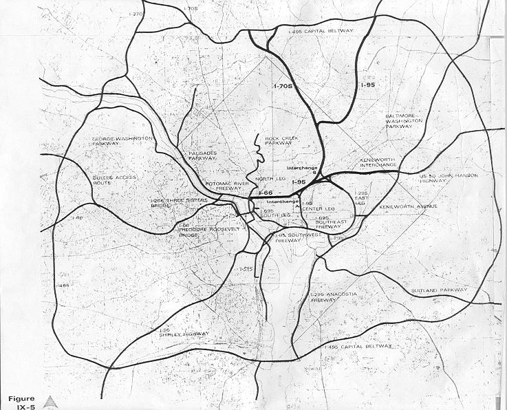
I've always wonder what DC would have looked like if they had built all the freeways that had been proposed in the '60s. I'm glad they didn't, but I do have fun driving on urban freeways like the BQE in New York, the Mass Pike in Boston, or the Southeast-Southwest Freeway here in DC. I gripe about how in DC (and Baltimore, for that matter) Freeways basically dead end in the city, dumping ridiculous volumes of automobile traffic in concentrated areas that ought to be more geared toward pedestrians. Either connect them, or get rid of them.
What is now I-395 was supposed to have connected along the Metropolitan Branch train line and connected to the stub at the I-95 interchange in College Park. Instead, it dead ends on New York Avenue, dumping thousands of cars onto what was intended to be a grand boulevard with vistas to the White House. Many of the funds from those abandoned highway projects were ultimately diverted to Metro. But the highway system proposed was far more in-depth than Metro today. Why didn't we match that ambition with trains?
Frankly, I don't care if the Shirley Highway is backed up. That highway is about six lanes wider than it ought to be anyway. I say, get rid of all those HOV lanes in the middle and add another Metro line, perhaps a light rail. Make it useful. Start it in Dale City, and have it run all along 95 and then 395 in the center lanes, all the way up toDC where it can connect underground to L'Enfant Plaza. Virginia commuters would then have the option to eschew the traffic on the freeway with a different kind of high occupancy vehicle: transit. Those giant empty spaces in the middle of highway exits? Throw parking garages in there. Giant park and rides taking tens of thousands of cars off the road every day.
I am curious to see what a study would say might happen if those HOV lanes were replaced with perhaps a light rail track with seamless connectivity to Metro stations (Franconia, Pentagon, and L'Enfant, perhaps).
Maybe this new line could even fight its way through the city and connect to I-95 in College Park, then head on up to Columbia. Sure it would be a long line, but it would do what ambitious freeway planners wanted I-95 to do: connect the region. Only this would be a far more responsible way of doing so.
Normally, I don't believe transit lines should run completely on freeways. I think freeways stifle the ability to place transit-oriented development around stations. I think a rail running along Rt. 1 in Maryland is far superior to one running along I-95, a parallel freeway a few miles west with no chance for promoting the same kind of good urbanism. But the Virginia portion of the above proposal would ostensibly replace a freeway, the one-way HOV lanes from Woodbridge to DC. Could trans move the same number of people during rush hour? They certainly would move people faster, considering they wouldn't have to suffer through Mixing Bowl traffic... they'd just speed right past it.
I wonder, has this proposal ever been thrown out there? Have such studies been conducted? Could a light rail move as many people as the HOV lanes, or would it have to be Metro, or something of even higher capacity?
Moving on from highways is going to take a plan as ambitious and extensive as the plan that put them here in the first place; a plan that can equal or best the largest public works project in human history. Why not start with superfluous lanes on a highway bringing thousands of people into the city every day?
What is now I-395 was supposed to have connected along the Metropolitan Branch train line and connected to the stub at the I-95 interchange in College Park. Instead, it dead ends on New York Avenue, dumping thousands of cars onto what was intended to be a grand boulevard with vistas to the White House. Many of the funds from those abandoned highway projects were ultimately diverted to Metro. But the highway system proposed was far more in-depth than Metro today. Why didn't we match that ambition with trains?
Frankly, I don't care if the Shirley Highway is backed up. That highway is about six lanes wider than it ought to be anyway. I say, get rid of all those HOV lanes in the middle and add another Metro line, perhaps a light rail. Make it useful. Start it in Dale City, and have it run all along 95 and then 395 in the center lanes, all the way up toDC where it can connect underground to L'Enfant Plaza. Virginia commuters would then have the option to eschew the traffic on the freeway with a different kind of high occupancy vehicle: transit. Those giant empty spaces in the middle of highway exits? Throw parking garages in there. Giant park and rides taking tens of thousands of cars off the road every day.
I am curious to see what a study would say might happen if those HOV lanes were replaced with perhaps a light rail track with seamless connectivity to Metro stations (Franconia, Pentagon, and L'Enfant, perhaps).
Maybe this new line could even fight its way through the city and connect to I-95 in College Park, then head on up to Columbia. Sure it would be a long line, but it would do what ambitious freeway planners wanted I-95 to do: connect the region. Only this would be a far more responsible way of doing so.
Normally, I don't believe transit lines should run completely on freeways. I think freeways stifle the ability to place transit-oriented development around stations. I think a rail running along Rt. 1 in Maryland is far superior to one running along I-95, a parallel freeway a few miles west with no chance for promoting the same kind of good urbanism. But the Virginia portion of the above proposal would ostensibly replace a freeway, the one-way HOV lanes from Woodbridge to DC. Could trans move the same number of people during rush hour? They certainly would move people faster, considering they wouldn't have to suffer through Mixing Bowl traffic... they'd just speed right past it.
I wonder, has this proposal ever been thrown out there? Have such studies been conducted? Could a light rail move as many people as the HOV lanes, or would it have to be Metro, or something of even higher capacity?
Moving on from highways is going to take a plan as ambitious and extensive as the plan that put them here in the first place; a plan that can equal or best the largest public works project in human history. Why not start with superfluous lanes on a highway bringing thousands of people into the city every day?
Wednesday, September 24, 2008
People Movers, Highway Removal, and Thoughts on Rosslyn
Update to yesterday's post: I recommend PRT for business campuses, when in fact a people mover is what I was thinking when I proposed the idea. Large, semi-on demand vehicles that could carry about 20 people at a time to one of a few destinations, much like the University of West Virginia's system. The more I think about it, the more my idea starts to look like a last mile light rail. Thanks to Cavan for the insightful link in his comment. It somewhat supported my theory that people movers were good for large campuses, and it also elucidated on many of the hyperbolic myths of PRT proposals. Once again, if it were really feasible, Europe and the Far East would have been doing it years ago.
***
Ryan Avent posted a story that recommending removal of the Southeast-Southwest Freeway (I-395) though downtown. I like the idea of getting rid of this highway and reestablishing the Axises for Maryland Avenue and Virginia Avenue. However I left a comment on Aven'ts site pondering the need for a regional study before removing a freeway, which was attacked by a couple of other commentors. Perhaps I didn't clearly state the thought that the study ought to be the precursor to a plan that not only eliminates the freeway, but also beefs up transit and walkability in the areas that feed the freeway set for removal. Is this such a bad idea? Seems like a win/win to me.
Perhaps what catalyzed the rebuttals was my mentioning that highways in DC have one benefit, insofar as they keep industrial and military traffic off the regular city streets. Industrial traffic is an eyesore, and ought to be limited on city streets with regulations, but I don't suppose it is a major issue if through industrial traffic traveled on roads like North Capitol Street and Pennsylvania Avenue. Undesirable, but not appalling.
Military traffic, on the other hand, has absolutely no business whatsoever on the city streets of the Nation's Capital. I firmly believe this. Military vehicles flying up and down monumental boulevards may fly in Moscow, Pyongyang, or Tehran, but it has no business happening in DC. Not in the Capital. not for all the tourists to see. Considering the Pentagon and three military bases (NAS Anacostia, Bolling AFB, and Ft. McNair) in Southeast are directly served by the Freeway plus indirect service to Ft. Meyer, Andrews AFB, Ft. Meade, Ft. Belvoir, and MCB Quantico, some considerations ought to be made with what to do with that traffic. Certainly a segregated two-way street ought to do the trick, but this also ought to be heavily considered with the removal of the freeway. The capital of any nation will need to serve military traffic, unfortunately, and we ought to give strong consideration to keeping this traffic off of the city streets at all costs.
***
I was in Rosslyn tonight. I've spent plenty of time around the other stations on that stretch of the Orange Line, but not Rosslyn. I was amazed at how dead that area is after 9pm on a weeknight. I went up to Court House (just one stop on Metro [don't worry I walked]) to get chili at Hard Times Cafe, and the difference was amazing. Pedestrians, storefronts, and night life could be observed buzzing with activity. I wonder why Rosslyn, which is served by two (and soon, three) Metro Lines is so dead after 9pm. Of course, one night there doesn't make me an expert. Perhaps I just chose a bad evening.
***
Ryan Avent posted a story that recommending removal of the Southeast-Southwest Freeway (I-395) though downtown. I like the idea of getting rid of this highway and reestablishing the Axises for Maryland Avenue and Virginia Avenue. However I left a comment on Aven'ts site pondering the need for a regional study before removing a freeway, which was attacked by a couple of other commentors. Perhaps I didn't clearly state the thought that the study ought to be the precursor to a plan that not only eliminates the freeway, but also beefs up transit and walkability in the areas that feed the freeway set for removal. Is this such a bad idea? Seems like a win/win to me.
Perhaps what catalyzed the rebuttals was my mentioning that highways in DC have one benefit, insofar as they keep industrial and military traffic off the regular city streets. Industrial traffic is an eyesore, and ought to be limited on city streets with regulations, but I don't suppose it is a major issue if through industrial traffic traveled on roads like North Capitol Street and Pennsylvania Avenue. Undesirable, but not appalling.
Military traffic, on the other hand, has absolutely no business whatsoever on the city streets of the Nation's Capital. I firmly believe this. Military vehicles flying up and down monumental boulevards may fly in Moscow, Pyongyang, or Tehran, but it has no business happening in DC. Not in the Capital. not for all the tourists to see. Considering the Pentagon and three military bases (NAS Anacostia, Bolling AFB, and Ft. McNair) in Southeast are directly served by the Freeway plus indirect service to Ft. Meyer, Andrews AFB, Ft. Meade, Ft. Belvoir, and MCB Quantico, some considerations ought to be made with what to do with that traffic. Certainly a segregated two-way street ought to do the trick, but this also ought to be heavily considered with the removal of the freeway. The capital of any nation will need to serve military traffic, unfortunately, and we ought to give strong consideration to keeping this traffic off of the city streets at all costs.
***
I was in Rosslyn tonight. I've spent plenty of time around the other stations on that stretch of the Orange Line, but not Rosslyn. I was amazed at how dead that area is after 9pm on a weeknight. I went up to Court House (just one stop on Metro [don't worry I walked]) to get chili at Hard Times Cafe, and the difference was amazing. Pedestrians, storefronts, and night life could be observed buzzing with activity. I wonder why Rosslyn, which is served by two (and soon, three) Metro Lines is so dead after 9pm. Of course, one night there doesn't make me an expert. Perhaps I just chose a bad evening.
Subscribe to:
Posts (Atom)

 Posts
Posts