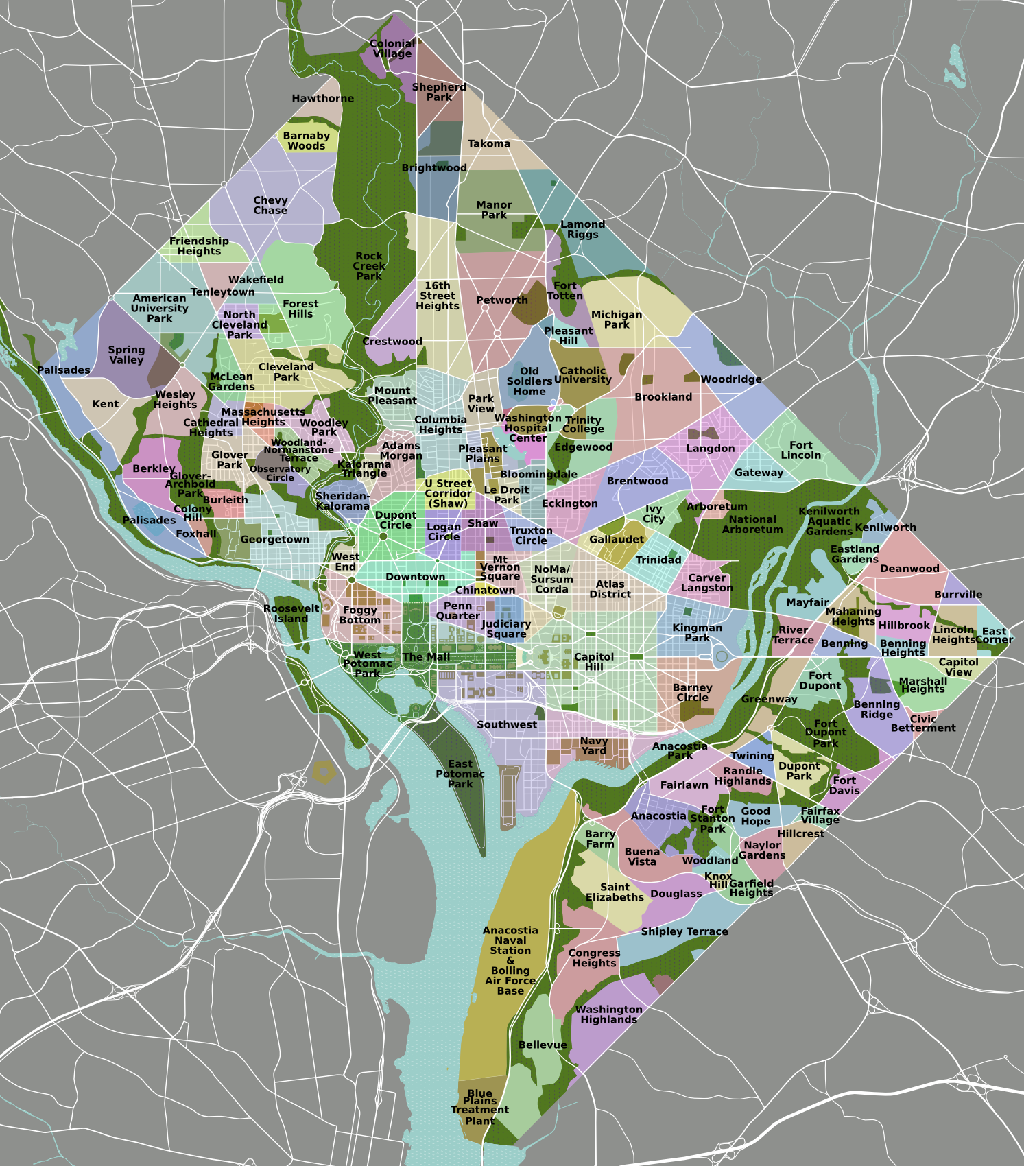
Northern DC has a huge swath of relatively dense urbanized area with little direct access to Metro. This area consists largely of the Petworth, 16th Street Heights, Brightwood, Manor Park, and Lamond Riggs neighborhoods, and the obvious reason is that there is no line running underneath Georgia Avenue. There are commercial corridors along this route on Georgia Avenue, Kennedy Street, Upshur Street, Blair Road.
While it is not economically feasible right now to dig underneath Georgia Avenue, that area is likely to get a streetcar connecting Silver Spring to the next station along Georgia, the Georgia Avenue/Petworth station (which technically is in Park View, just south of Petworth). The eastern reaches of this area would not benefit as much from this new transit line, however the opportunity exists to add a Metro station along the Red Line in the Lamond-Riggs neighborhood at Kansas Avenue and Blair Road:
View Larger Map
This station would lie about halfway between Takoma and Fort Totten, which are just under two miles apart. It would directly serve the Blair Road retail corridor, and if placed on the southeast side of Kansas Avenue, the New Hampshire Avenue corridor would be directly served as well.
What makes this site particularly amenable to a transit station is the plethora of suitable approaches. Peabody Street heads west and in less than a mile hits Georgia Avenue in the Vinegar Hill/Fort Stevens area. New Hampshire and Kansas Avenues head southwest into the heart of Petworth, an important neighborhood in the heart of northwest, densely populated and undergoing a true renaissance. New Hampshire Avenue also heads north through Takoma Park towards Langley Park, and this new station could serve as a hub for bus lines along New Hampshire.
Blair Road already connects this area to the Takoma station area, and linking transit-oriented developments can have a synergistic effect on the areas, like along the Orange Line in Arlington or the downtown areas in DC. To the south, Blair Road becomes North Capitol Street and crosses Riggs Road/Missouri Avenue near Fort Totten, another area which is rapidly growing. As Takoma and Fort Totten grow with more walkable, transit accessible developments, a station placed in between them could induce a string-of-pearls transit-oriented development environment that could become the focus of the northern part of the District, improving transit accessibility and the potential for growth and development. And it could be done without spending a single dime laying more track.
I imagine the first criticism of this station would be that it increases the time it takes to get downtown. For some, yes. However, there is an express train from Silver Spring to Union Station known as the MARC Brunswick Line. For many residents in Lamond Riggs, Manor Park, Takoma, Brightwood, and Petworth, it will most certainly shorten the amount of time it takes for them to get downtown. Considering the benefits of added grown and increased economic viability, adding one or two minutes to get downtown might be worth it. It certainly was at the New York Avenue station, which opened just six years ago and has induced billions in economic investment, even during troubled economic times.
What would this station be called? Track Twenty-Nine suggested "Kansas Avenue" some time ago, however I am partial to naming it after the neighborhood, Lamond-Riggs, or perhaps Fort Slocum after the nearby park and Civil War fortification. Though perhaps not well known right now, Lamond-Riggs has the potential to become a keystone for development along the northern edge of the District.
Wednesday, February 24, 2010

Wednesday, February 17, 2010
Sneak Peek at Imagine, DC Transit Vision
Further explanation forthcoming, but at the GGW meet-up in Silver Spring tonight, a couple folks asked me about it, so here it is
What is on it?
-Potential extension of existing and under construction Metro Lines (including Silver), separated from each other to maximize capacity
-Two Metro Light Rail lines, the Purple Line (proposed) and the Black or "Columbia" Line (which hits Columbia Pike in MoCo, Columbia Heights, and Columbia Pike in VA)
-A vision for DC streetcars (red), Ride-On streetcars (light blue), streetcars for municipalities in Prince George's (various blues and purples), ART/DART (light green) and Fairfax Connector (white)
-Southern Maryland Area Rail Transport (SMART light rail, in yellow)
What's not on here yet:
-Corridor Cities Transitway
-MARC/VRE
-Baltimore Transit
-A "Pink Line" heavy rail inner loop
-A "Brown Line" crosstown light rail
I probably won't add these, it doesn't mean I don't think we should have them:
-Tram/Streetcar stations
-Intercity/HSR/MagLev
-Rapid/express bus (vision supplants most of this with rail anyway)
-Redevelopment and suburban ruralization that would ideally accompany this sort of plan
-Bicycle facilities (not my wheelhouse... yet)
-New/changed/removed freeways, parkways, and interchanges, as well as newly tolled roads
Here's a disclaimer: I am not under the delusion that this vision is feasible, politically expedient, affordable, cost effective, or in any other way possible. But I imagine it would be able to quickly and safely transport most of the area's growing population after gas prices breach the threshold of affordability.
Sorry I am currently incapable of putting together a beautiful graphic like many of my fellow transit nerds at BeyondDC, Track Twenty-Nine, or Greater Greater Washington, but hopefully the arrangement I have thrown together on GoogleMaps will give people an idea of what I'm going for here.
What is on it?
-Potential extension of existing and under construction Metro Lines (including Silver), separated from each other to maximize capacity
-Two Metro Light Rail lines, the Purple Line (proposed) and the Black or "Columbia" Line (which hits Columbia Pike in MoCo, Columbia Heights, and Columbia Pike in VA)
-A vision for DC streetcars (red), Ride-On streetcars (light blue), streetcars for municipalities in Prince George's (various blues and purples), ART/DART (light green) and Fairfax Connector (white)
-Southern Maryland Area Rail Transport (SMART light rail, in yellow)
What's not on here yet:
-Corridor Cities Transitway
-MARC/VRE
-Baltimore Transit
-A "Pink Line" heavy rail inner loop
-A "Brown Line" crosstown light rail
I probably won't add these, it doesn't mean I don't think we should have them:
-Tram/Streetcar stations
-Intercity/HSR/MagLev
-Rapid/express bus (vision supplants most of this with rail anyway)
-Redevelopment and suburban ruralization that would ideally accompany this sort of plan
-Bicycle facilities (not my wheelhouse... yet)
-New/changed/removed freeways, parkways, and interchanges, as well as newly tolled roads
Here's a disclaimer: I am not under the delusion that this vision is feasible, politically expedient, affordable, cost effective, or in any other way possible. But I imagine it would be able to quickly and safely transport most of the area's growing population after gas prices breach the threshold of affordability.
Sorry I am currently incapable of putting together a beautiful graphic like many of my fellow transit nerds at BeyondDC, Track Twenty-Nine, or Greater Greater Washington, but hopefully the arrangement I have thrown together on GoogleMaps will give people an idea of what I'm going for here.
Sunday, February 7, 2010
Keeping Money In the Community
My New Years resolution was to eat at more independently owned food joints. Originally, I opted to do this to get a better taste for DC cuisine, but there is a reason that benefits everyone to seek local fare from locally owned restaurants. That money comes flowing back to you by keeping the money in the place where you live. And this goes for everything, not just food.
I purchase some pork tenderloin at the Wal-Mart in Maryland City, the money goes a lot of places. New York investors, Chinese suppliers, various distributors, and of course the fat cats in Benton, AR where Wal-Mart started. But where doesn't it go? Laurel. Prince George's County. And for the most part, the State of Maryland. My hard earned cash is going to support gated communities like Hot Springs Village, AR, the largest gated community in the United States and not surprisingly convenient to Benton.
If I purchase the same pork tenderloin at the Laurel meat market on Main Street, my money is not going through all the corporate filters of a Wal-Mart. The product is more likely to come from the state of Maryland and will probably be fresher. A larger percentage of the taxed monies will go to the city of Laurel, Prince George's County, and Maryland. And a retailer that depends on the community. Those taxes will go towards investment in my city, not a segregated community halfway across the country with a disproportionate lack of minority population.
River East Idealist had a great article last week on how River East residents can keep their money in River East and break the debt cycle in which many less fortunate River East residents are mired. Her first point was to stop attending colleges you can't afford. I like to think I'm living proof that this works. I have an Associates of Applied Science from Montgomery College. I educated myself where I lived, and I now have what could be considered a decent paying job and a rather prestigious position in Federal Government. Of course, if you can find a way afford a degree from a better more expensive school, go for it. But educating yourself outside your means is not necessary. I believe I am doing much better than most of my friends with bachelors degrees from more prestigious institutions because I do not have six figure student loan debt. My six figure debt is a mortgage on the house I own.
Another observation she made: stop financing cars. If the money Americans spent on the interest alone of financed cars were instead spent on public transportation infrastructure, I wonder how much better our systems would be. If that were the case, I speculate many Americans would not even bother to own a car. At the very least, I bet Metro would not be facing such a tremendous budget gap.
There are a plethora of ways we can keep our money in the community continuing to benefit us. But it is important that those methods be accessible to everyone, regardless of their socio-economic status. Policy ought to be enacted promoting locally owned businesses over chains, mass transit over car ownership, and better investment in local schools to create sharp minds and keep them nearby. The status quo will continue to send money to out of touch corporations and Wall Street investors while siphoning investment away from our own communities.
I purchase some pork tenderloin at the Wal-Mart in Maryland City, the money goes a lot of places. New York investors, Chinese suppliers, various distributors, and of course the fat cats in Benton, AR where Wal-Mart started. But where doesn't it go? Laurel. Prince George's County. And for the most part, the State of Maryland. My hard earned cash is going to support gated communities like Hot Springs Village, AR, the largest gated community in the United States and not surprisingly convenient to Benton.
If I purchase the same pork tenderloin at the Laurel meat market on Main Street, my money is not going through all the corporate filters of a Wal-Mart. The product is more likely to come from the state of Maryland and will probably be fresher. A larger percentage of the taxed monies will go to the city of Laurel, Prince George's County, and Maryland. And a retailer that depends on the community. Those taxes will go towards investment in my city, not a segregated community halfway across the country with a disproportionate lack of minority population.
River East Idealist had a great article last week on how River East residents can keep their money in River East and break the debt cycle in which many less fortunate River East residents are mired. Her first point was to stop attending colleges you can't afford. I like to think I'm living proof that this works. I have an Associates of Applied Science from Montgomery College. I educated myself where I lived, and I now have what could be considered a decent paying job and a rather prestigious position in Federal Government. Of course, if you can find a way afford a degree from a better more expensive school, go for it. But educating yourself outside your means is not necessary. I believe I am doing much better than most of my friends with bachelors degrees from more prestigious institutions because I do not have six figure student loan debt. My six figure debt is a mortgage on the house I own.
Another observation she made: stop financing cars. If the money Americans spent on the interest alone of financed cars were instead spent on public transportation infrastructure, I wonder how much better our systems would be. If that were the case, I speculate many Americans would not even bother to own a car. At the very least, I bet Metro would not be facing such a tremendous budget gap.
There are a plethora of ways we can keep our money in the community continuing to benefit us. But it is important that those methods be accessible to everyone, regardless of their socio-economic status. Policy ought to be enacted promoting locally owned businesses over chains, mass transit over car ownership, and better investment in local schools to create sharp minds and keep them nearby. The status quo will continue to send money to out of touch corporations and Wall Street investors while siphoning investment away from our own communities.
Tuesday, January 12, 2010
Depressing Places
 This weekend, my job had me going to a site up in Columbia Gateway, a sprawling, depressing office colony in Howard County. It is an intimidatingly isolated, desolate, oppressing void of a place. I grew furious trying to figure out which anonymous LeCorbuseurian complex housed the site where I was meeting my colleagues. It was a very depressing landscape, and I couldn't wait to leave.
Then it dawned on me that thousands of people work here every day.
Columbia Gateway. Photo by Howard County
I find my self oppressed by the traffic-choked pedestrian-hazardous landscape of Laurel Lakes, and I am doing everything in my power to move. But push comes to shove, I can walk to the store. If someone is causing problems in my neighborhood, it will be noticed and police will be called. Those police shouldn't have too much problem finding the suspects. It is Lower Manhattan compared to Columbia Gateway (except they have the skyscrapers up there).
Perhaps I am ruminating on the concept too much. I may be reading too much James Howard Kuntsler. But then CNN illustrated human's desire for beautiful and memorable settings. The visual stimulation of the beautiful planet in the hit film Avatar is striking people on such a level that going back to the cul-de-sacs, drive-thru fast food joints, and office parks of reality has caused them depression.
I have not seen Avatar yet, but I plan to do so soon after reading the CNN article. I know the symptoms. I was a little depressed when I returned from my two months in Europe, having seen such awe-inspiring places as the Abbey at Fauntevrault, the American Cemetary in Luxembourg, Heidelburg Castle, Chateau Vianden, the Ardennes Forest, Die Bergstrasse, the Amsterdam canals, and Chateau d'Angers and then returning home to the billboard littered landscapes of Route 1 in Laurel. Fortunately, I go to downtown Silver Spring, Clarendon, H Street, Hyattsville, Chinatown, or one of the DC area's many other great places, and I get over it. They may not be on par with the beauty and sense of places as the Abbey at Fauntevrault, but they are memorable places designed for enjoyment of people.
Perhaps the visual magnificence of Avatar is so otherworldly beautiful and James Cameron has accomplished something truly profound. I'll let you know after I watch it. But perhaps many Americans are already depressed by their lack of access to truly beautiful places, and Avatar simply defined that their need for such places that was already festering inside them.
Thursday, January 7, 2010
Coast Guard HQ: 2,000 Cars, No Boats
A historic campus. An idyllic untouched corner of real estate in close proximity to the seat of federal government for a great nation. The headquarters of an esteemed branch of the military and an a department headquarters for a government agency. No nation on earth could improve on a venture like that. But in the United States, we throw in a 1900 space garage.
The United States Coast Guard Headquarters design has been approved. I'm not an architect nor am I capable of eloquently stating my disgust at a coast guard headquarters that looks like a spa retreat off in the woods despite the nearby convergence of two navigable rivers, but I will openly take issue with the 1,973 space garage. It is definitely better than surface parking, but this is a historic site, virgin land with views of the convergence of the rivers, the Capitol, and the monuments. Real estate in America doesn't get more prime than this. And DHS is dropping a greenified Tyson's Corner transplant with a huge garage in the middle of it, complete with a sexed up drainage pond and ample parking.
I've advocated that a campus like this ought to house an institution of higher learning, particularly UDC. To me, that would be the ideal way to dignify that site (Although I don't know what your average UDC student would think about moving into dorms that formerly housed mental patients... but one would think the good people hat DHS and the Coast Guard would have similar concerns!)
I'll admit my reaction is perhaps a bit pessimistic considering that I have not seen an illustration or elevation that contextualizes the complex amongst the St. E's buildings, but with streetcars imminent, location near two Metro stations, and traffic congestion already problematic, a huge parking garage has me worried that this is just going to be another office park like those in Columbia, Gaithersburg, or Tyson's Corner.
The garage is built into a slope visible from Haines Point. Several measures were put in place to minimize the visual impact of the structure, such as putting more of it underground and a green wall system on the northern facade, however on an important site like this with available transit alternatives, I would expect better planning and land use than a green-guilt version of the same disposable crap office box we have all come to know and hate.
Students of architecture, I beg your input on this one. I am at a loss for words. If the Army built something that ugly, I would be even more embarrassed as a veteran than I am when West Point gets annihilated by the Naval Academy in football every December.
The United States Coast Guard Headquarters design has been approved. I'm not an architect nor am I capable of eloquently stating my disgust at a coast guard headquarters that looks like a spa retreat off in the woods despite the nearby convergence of two navigable rivers, but I will openly take issue with the 1,973 space garage. It is definitely better than surface parking, but this is a historic site, virgin land with views of the convergence of the rivers, the Capitol, and the monuments. Real estate in America doesn't get more prime than this. And DHS is dropping a greenified Tyson's Corner transplant with a huge garage in the middle of it, complete with a sexed up drainage pond and ample parking.
I've advocated that a campus like this ought to house an institution of higher learning, particularly UDC. To me, that would be the ideal way to dignify that site (Although I don't know what your average UDC student would think about moving into dorms that formerly housed mental patients... but one would think the good people hat DHS and the Coast Guard would have similar concerns!)
I'll admit my reaction is perhaps a bit pessimistic considering that I have not seen an illustration or elevation that contextualizes the complex amongst the St. E's buildings, but with streetcars imminent, location near two Metro stations, and traffic congestion already problematic, a huge parking garage has me worried that this is just going to be another office park like those in Columbia, Gaithersburg, or Tyson's Corner.
The garage is built into a slope visible from Haines Point. Several measures were put in place to minimize the visual impact of the structure, such as putting more of it underground and a green wall system on the northern facade, however on an important site like this with available transit alternatives, I would expect better planning and land use than a green-guilt version of the same disposable crap office box we have all come to know and hate.
Students of architecture, I beg your input on this one. I am at a loss for words. If the Army built something that ugly, I would be even more embarrassed as a veteran than I am when West Point gets annihilated by the Naval Academy in football every December.
Sunday, January 3, 2010
Imagine a streetcar on Alabama Avenue
When DDOT unveiled its Streetcar vision in October, I was little disappointed by the amount of service in River East. Indeed, the area's reputation has been mired in negativity for quite some time, which has lead to, for better or worse, a very different kind of land and economic development in Wards 7 and 8. This is evident in the distribution of services proposed by DDOT.
River East has experienced a great deal of suburban style development. Wickedly suburban. Affordable housing is often not accessible to the six Metro stations that serve this third of the city. Isolated affordable housing can often turn out to be frighteningly similar to ill-fated housing projects. Requiring people of lower income to rely on automobile transport greatly increases their cost of living, further exacerbating the poverty. But shiny new developments in River East, for all their efforts at civic improvement, are still focused around the automobile.
What really disappointed me about DDOT's plan is that all the streetcar lines appear to run THROUGH River East. Along the Anacostia River, perhaps, but they fail to connect many of the neighborhoods to the system, including several that are not very accessible to Metro. This plan would lead me to infer that Congress Heights and Fairlawn are and will be for the foreseeable future dependent on the rest of the city to be a viable place to live. The lines connect River East to the rest of the city, but they don't connect River East to River East. Not as much as it could, at least.
With DC's population rocketing past 600,000 and developers running out of "River West" real estate to develop, Benning, Deanwood, Anacostia, Washington Highlands, Hillcrest, Fort Dupont, and the rest of River East's many neighborhoods will becoming increasingly attractive for development. But the same type of dense, walkable, transit-oriented, traditional neighborhood design is not possible if River East goes as underserved by streetcar as it is by Metro (6 stations versus 31 in the rest of DC and not transfer stations). So I conceived a line that would make it feasible to live in Congress Heights and work in Capitol Heights without taking Metro all the way to L'Enfant Plaza first. I give you a proposal for a ninth streetcar line, the Alabama Avenue line:
View River East Streetcars in a larger map
Blue indicates lines laid out in the DDOT plan, purple indicates possible future streetcar extension laid out in the plan, and red is the Alabama Avenue line. Obviously, significant portions of the line also run along Southern Avenue and Nannie Helen Burroughs Avenue. It connects prominent neighborhoods to Metro stations and other streetcar lines. It puts more of the rail transit infrastructure within walking distance for District residents who will benefit most from its service and economic development. It is intended to interact with the neighborhoods as places where a significant portion of the District now lives and could potentially work in the future.
Where the city will ultimately have a streetcar network, River East will only have lines. The Alabama Avenue line would create a network that would compliment the existing Metro stations and the already-planned streetcar lines. It may not generate enormous ridership projections right now, but it would certainly draw more walkable urban development to Alabama Avenue and the other proposed corridors. We plan roads in anticipation of future development. Why can't we make that same investment with our streetcar network?
Cross-posted on Imagine, DC
River East has experienced a great deal of suburban style development. Wickedly suburban. Affordable housing is often not accessible to the six Metro stations that serve this third of the city. Isolated affordable housing can often turn out to be frighteningly similar to ill-fated housing projects. Requiring people of lower income to rely on automobile transport greatly increases their cost of living, further exacerbating the poverty. But shiny new developments in River East, for all their efforts at civic improvement, are still focused around the automobile.
What really disappointed me about DDOT's plan is that all the streetcar lines appear to run THROUGH River East. Along the Anacostia River, perhaps, but they fail to connect many of the neighborhoods to the system, including several that are not very accessible to Metro. This plan would lead me to infer that Congress Heights and Fairlawn are and will be for the foreseeable future dependent on the rest of the city to be a viable place to live. The lines connect River East to the rest of the city, but they don't connect River East to River East. Not as much as it could, at least.
With DC's population rocketing past 600,000 and developers running out of "River West" real estate to develop, Benning, Deanwood, Anacostia, Washington Highlands, Hillcrest, Fort Dupont, and the rest of River East's many neighborhoods will becoming increasingly attractive for development. But the same type of dense, walkable, transit-oriented, traditional neighborhood design is not possible if River East goes as underserved by streetcar as it is by Metro (6 stations versus 31 in the rest of DC and not transfer stations). So I conceived a line that would make it feasible to live in Congress Heights and work in Capitol Heights without taking Metro all the way to L'Enfant Plaza first. I give you a proposal for a ninth streetcar line, the Alabama Avenue line:
View River East Streetcars in a larger map
Blue indicates lines laid out in the DDOT plan, purple indicates possible future streetcar extension laid out in the plan, and red is the Alabama Avenue line. Obviously, significant portions of the line also run along Southern Avenue and Nannie Helen Burroughs Avenue. It connects prominent neighborhoods to Metro stations and other streetcar lines. It puts more of the rail transit infrastructure within walking distance for District residents who will benefit most from its service and economic development. It is intended to interact with the neighborhoods as places where a significant portion of the District now lives and could potentially work in the future.
Where the city will ultimately have a streetcar network, River East will only have lines. The Alabama Avenue line would create a network that would compliment the existing Metro stations and the already-planned streetcar lines. It may not generate enormous ridership projections right now, but it would certainly draw more walkable urban development to Alabama Avenue and the other proposed corridors. We plan roads in anticipation of future development. Why can't we make that same investment with our streetcar network?
Cross-posted on Imagine, DC
Thursday, December 31, 2009
New Years Resolution
With the new decade upon us, I have decided to make on very important New Year's resolution: Eat at fewer chain restaurants. Recently I've been discovering local hole-in-the-wall joints like Dumm's in Riverdale Park. Want a decent half-smoke but you're in Silver Spring? Try Quarry House Tavern. When i'm hankering for a sub at work in College Park, do I go to Subway, Potbelly's or Quiznos? How about Jungle Grille on Route 1 instead? Need a quick late-night meal in South Arlington? Try Bob and Edith's Diner.
Apart from the fact that you are likely to get much better customer service and more/better food for the dollar at locally owned establishments like these, they keep money in the community. Panera might be great, but nothing beats the sandwiches at the Parkway Deli in Silver Spring. And better yet, the define a sense of culture unique to a very small area, like my old haunt the Corner Pub in Four Corners, or the Stained Glass Pub in Glenmont.
 The punk rocker in me likes to think that I am keeping my hard earned cash out of the pockets of "the man", but the fact of the matter is it is an economically sound decision, and it enriches my sense of local culture. Ben's Chili Bowl on U Street is a hyperbolic example of how a food restaurant can capture the character of a neighborhood. Some places are late night joints for bargoers, like Tastee Diner in Silver Spring and Bethesda and Steak and Eggs in Tenleytown. And what UMD student has never spent a late Saturday night at Plato's Diner?
Plato's Diner in College Park. Photo from flickr by Steve Snodgrass
I tend to move about the entire region so if anyone has a favorite watering hole, lunch counter, or grease pit that's not of the ilk of McDonalds, Chipotle, TGI Fridays, or Panera, by all means share with me and the rest of our readers. So for one of your resolutions this new year, I encourage you to forgo Starbucks for your morning coffee, and instead patronize a more local institution and keep the money flowing around your neck of the woods.
And of course, Happy New Year, DC!!!
Apart from the fact that you are likely to get much better customer service and more/better food for the dollar at locally owned establishments like these, they keep money in the community. Panera might be great, but nothing beats the sandwiches at the Parkway Deli in Silver Spring. And better yet, the define a sense of culture unique to a very small area, like my old haunt the Corner Pub in Four Corners, or the Stained Glass Pub in Glenmont.
 The punk rocker in me likes to think that I am keeping my hard earned cash out of the pockets of "the man", but the fact of the matter is it is an economically sound decision, and it enriches my sense of local culture. Ben's Chili Bowl on U Street is a hyperbolic example of how a food restaurant can capture the character of a neighborhood. Some places are late night joints for bargoers, like Tastee Diner in Silver Spring and Bethesda and Steak and Eggs in Tenleytown. And what UMD student has never spent a late Saturday night at Plato's Diner?
 Plato's Diner in College Park. Photo from flickr by Steve Snodgrass
I tend to move about the entire region so if anyone has a favorite watering hole, lunch counter, or grease pit that's not of the ilk of McDonalds, Chipotle, TGI Fridays, or Panera, by all means share with me and the rest of our readers. So for one of your resolutions this new year, I encourage you to forgo Starbucks for your morning coffee, and instead patronize a more local institution and keep the money flowing around your neck of the woods.
And of course, Happy New Year, DC!!!
Saturday, December 19, 2009
Snow Emergency: Don't Walk
Having experienced many of my Christmases as a youth in Buffalo, I'm generally nonplussed by big snow storms. This one has confined me to my house, however, and I've been watching the madness unfold on News Channel 8, where they are warning us not to venture outside our houses if we don't have to do so.

Route 1 in Laurel, taken from the front of the Greene Turtle. Plenty of cars were out despite warnings, making pedestrian conditions hazardous. Photo by the author.
Generally, that's very good advice. However, they were showing footage of pedestrians crossing streets and dismissing it as wildly dangerous behavior because, hey, cars gotta use those streets! Certainly driving conditions merit warnings, but why are we chiding the pedestrians instead of the people driving non-emergency vehicles? How are pedestrians expected to stay out of the streets when public services are focusing efforts on clearing roadways while ignoring sidewalks?
Prince George's County Executive Jack Johnson declared a state of emergency because so many county residents failed to heed warnings not to drive. I saw a few of those obstinate drivers on my walk to the Safeway in my neighborhood... which of course was closed. In fact, the only things open in Laurel Lakes Shopping Center were a nail salon (?) and a liquor store. Eventually I found an open 7-11, but suffice to say there was a lack of healthy diet staples. The proprietor, Pankaj, had walked to his store this morning to make sure Laurel Lakes could at least purchase Hot Pockets and yogurt smoothies if nothing else. This really made me wish my neighborhood had live-work units. Not to mention sidewalks.
Despite my lack of healthy food, open shops, and decent pedestrian facilities, at least I wasn't threatened with a gun during a snowball fight. A public gathering in the public realm at 14th and U NW was broken up because... wait for it... a car was hit by a couple of snowballs. The man brandishing the weapon was an off-duty policeman. The message: People don't matter in a snow emergency. Cars do.

Generally, that's very good advice. However, they were showing footage of pedestrians crossing streets and dismissing it as wildly dangerous behavior because, hey, cars gotta use those streets! Certainly driving conditions merit warnings, but why are we chiding the pedestrians instead of the people driving non-emergency vehicles? How are pedestrians expected to stay out of the streets when public services are focusing efforts on clearing roadways while ignoring sidewalks?
Prince George's County Executive Jack Johnson declared a state of emergency because so many county residents failed to heed warnings not to drive. I saw a few of those obstinate drivers on my walk to the Safeway in my neighborhood... which of course was closed. In fact, the only things open in Laurel Lakes Shopping Center were a nail salon (?) and a liquor store. Eventually I found an open 7-11, but suffice to say there was a lack of healthy diet staples. The proprietor, Pankaj, had walked to his store this morning to make sure Laurel Lakes could at least purchase Hot Pockets and yogurt smoothies if nothing else. This really made me wish my neighborhood had live-work units. Not to mention sidewalks.
Despite my lack of healthy food, open shops, and decent pedestrian facilities, at least I wasn't threatened with a gun during a snowball fight. A public gathering in the public realm at 14th and U NW was broken up because... wait for it... a car was hit by a couple of snowballs. The man brandishing the weapon was an off-duty policeman. The message: People don't matter in a snow emergency. Cars do.
Saturday, December 5, 2009
PG Stands for Poor Growth
Now, I like to stick up for my county. I believe that in many ways, Prince George's County has been dealt the short end of the smart growth stick. But the fact is that the county government isn't even trying, and it seems that any smart, transit oriented growth that does occur happens by accident or coincidence.

What puts me over the edge was this Washington Post article in Greater Greater Washington's Breakfast Links. A concrete plant has been approved near Sheriff and Cabin Branch Roads near Fairmount Heights.The Post article points out the multitude of other industrial plants near this site, surrounded on all sides by middle class residential zoning. GGW highlights this concentration, pointing out that the region in majority black. Pushing around non-wealthy minorities is not a new thing Prince George's County.
Cheverly Metro Station. Photo by Genista from Flickr
But what the Post doesn't point out is that the site where this concrete plant has been approved is less than a mile from Cheverly Metro station, one of the most underused stations on Metro. And it's on the same side of US-50 as the Metro station, meaning that useful growth could potentially occur in that area if Prince George's County wasn't treating it as a dumping ground for undesirable industry. It's a location inside the Beltway with easy access to the city and multiple forms of transit, including two Metrobuses that directly serve the site, five Metro stations within two miles (Cheverly, Landover, Deanwood, and Capitol Heights, and Addison Road-Seat Pleasant), and an Amtrak and MARC station at New Carrollton under three miles from the site. This is not the first, but only the latest controversy where PG County has throw its citizens under the bus and tried to drop an industrial plant in residential areas near Metro stations.
This site could be used for transit-oriented development at Cheverly station. It could be a crossroads between Cheverly and Capitol Heights. Instead it is home to an asphalt plant, a recycling transfer station, and a clay mine. And now, coming soon, a concrete plant. These uses would be far more suitably placed along US 50 outside the Beltway just a few short miles away, alas those areas have been blanketed with very low density McMansion developments. Byzantine laws promoting sprawl in PG will continue to force industrial growth in inappropriate places, including Fairmount Heights, one of the oldest black settlements in Maryland.
Prince George's County will not continue to prosper as it runs out of agricultural land while continuing to neglect its valuable inner ring suburbs. Transit investment will continue to be difficult to justify, making it more difficult to fund. And PG will continue to mean poor growth until the county's planning begins to take a look towards the future with regard to land use economy.

Cheverly Metro Station. Photo by Genista from Flickr
But what the Post doesn't point out is that the site where this concrete plant has been approved is less than a mile from Cheverly Metro station, one of the most underused stations on Metro. And it's on the same side of US-50 as the Metro station, meaning that useful growth could potentially occur in that area if Prince George's County wasn't treating it as a dumping ground for undesirable industry. It's a location inside the Beltway with easy access to the city and multiple forms of transit, including two Metrobuses that directly serve the site, five Metro stations within two miles (Cheverly, Landover, Deanwood, and Capitol Heights, and Addison Road-Seat Pleasant), and an Amtrak and MARC station at New Carrollton under three miles from the site. This is not the first, but only the latest controversy where PG County has throw its citizens under the bus and tried to drop an industrial plant in residential areas near Metro stations.
This site could be used for transit-oriented development at Cheverly station. It could be a crossroads between Cheverly and Capitol Heights. Instead it is home to an asphalt plant, a recycling transfer station, and a clay mine. And now, coming soon, a concrete plant. These uses would be far more suitably placed along US 50 outside the Beltway just a few short miles away, alas those areas have been blanketed with very low density McMansion developments. Byzantine laws promoting sprawl in PG will continue to force industrial growth in inappropriate places, including Fairmount Heights, one of the oldest black settlements in Maryland.
Prince George's County will not continue to prosper as it runs out of agricultural land while continuing to neglect its valuable inner ring suburbs. Transit investment will continue to be difficult to justify, making it more difficult to fund. And PG will continue to mean poor growth until the county's planning begins to take a look towards the future with regard to land use economy.
Saturday, November 21, 2009
Core Capacity & Freemark's Pink Line
The Transport Politic often showcases unique and clever transit solutions visualized by the site's author, Yonah Freemark. Recently he looked into the WMATA system and made an interesting proposal: a separated Blue Line, and running along it, another investment, a so-called Pink Line. Though Freemark's plan would add invaluable capacity and connectivity to our system, I believe a similar vision could be achieved without building another costly Potomac Crossing. That's not to say we shouldn't, but perhaps a closer term solution might look more like this:
View Pink Line in a larger map
The existing Potomac crossing where the Yellow Line connects Downtown and Pentagon City is underutilized and ought to have it's capacity increased before another crossing is built. This alternative combines the cross-Arlington connectivity that Freemark envisions without the circuitous route back through Rosslyn. This investment could be increased even more if the Green and Yellow Lines could be separated downtown, which might prove cheaper than the Blue Line separation. Another advantage would be that this line could just be an extension of the Silver Line, which would eliminate the need for a new line color.
New track miles are most valuable in the core. Unfortunately, they're also generally the most expensive new track miles. But the benefits to the entire region are huge across the entire system, making it a worthwhile investment. And it's about time we started considering "the rest of Arlington" more a part of the core.
View Pink Line in a larger map
The existing Potomac crossing where the Yellow Line connects Downtown and Pentagon City is underutilized and ought to have it's capacity increased before another crossing is built. This alternative combines the cross-Arlington connectivity that Freemark envisions without the circuitous route back through Rosslyn. This investment could be increased even more if the Green and Yellow Lines could be separated downtown, which might prove cheaper than the Blue Line separation. Another advantage would be that this line could just be an extension of the Silver Line, which would eliminate the need for a new line color.
New track miles are most valuable in the core. Unfortunately, they're also generally the most expensive new track miles. But the benefits to the entire region are huge across the entire system, making it a worthwhile investment. And it's about time we started considering "the rest of Arlington" more a part of the core.
Subscribe to:
Posts (Atom)

 Posts
Posts